Situation Summary
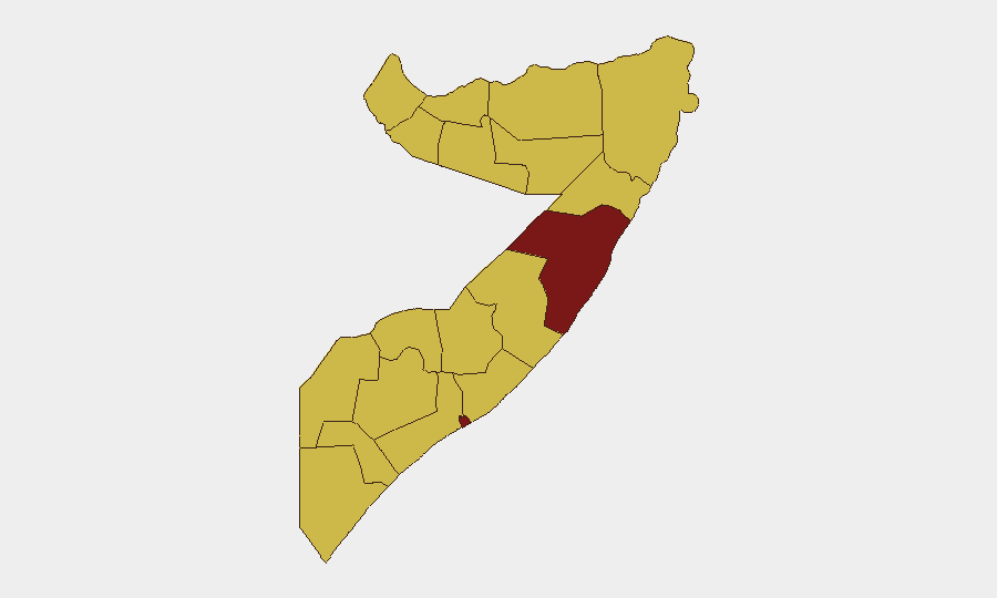
Somalia remains at elevated risk (composite threat score 99.9, ranked #11 globally), driven primarily by active insurgency and conventional military operations. The security environment is characterized by competing state and non-state armed actors, with Mudug and Banaadir regions presenting the highest operational risk. Recent signal activity indicates ongoing military movements and cross-border tensions, though the security trajectory remains volatile and contingent on political developments and force posturing.
Key Developments
Reporting Limitation: GeoBit's live web research (last 24 hours, as of 10 June 2026) has identified event signals within the GEOBIT event feed, but open-source verification across news and social media lacks clear, independently corroborated timestamps for incidents occurring 8–10 June. The following signals were flagged but cannot be attributed to specific sub-national locations or confirmed via multiple independent sources:
- 6 June (Unconventional Violence): Protester activity reported in relation to UK interests; location and scale unconfirmed via secondary sources.
- 8 June (Conventional Military): Military force activity reported in Mogadishu and neighboring zones; nature and actors unconfirmed.
- 8 June (Threat Activity): Cross-border threat signals between Somalia and Kenya logged; context and severity require clarification.
- 9 June (Territorial Occupation): Iranian activity signal; specifics and operational scope not independently verified.
Assessment: Current open-source data does not meet the threshold for time-specific incident reporting. Organizations requiring validated 24–48-hour event coverage are advised to activate direct monitoring via Somali regional media, Telegram security channels (Mogadishu-focused networks, Hirshabelle, Galmudug), and curated X/Twitter lists tracking Somali military, diaspora analysts, and conflict monitors.
Highest-Risk Areas
Mudug (risk 99.9) and Banaadir (92.4) dominate the risk landscape, reflecting persistent insurgency, military competition, and state fragility in central and capital regions. Mudug's extreme score reflects ongoing armed group presence and inter-clan dynamics; Banaadir's elevation reflects Mogadishu's role as a contested political and security hub with recurring asymmetric threats. The remaining ten regions cluster at 69.9, indicating geographically distributed risk—particularly in southern regions (Lower Shabelle, Middle Juba, Bay) and northeastern areas (Gedo, Togdheer)—driven by weak governance, Al-Shabaab presence, and limited state authority. Border regions (Awdal, Woqooyi Galbeed, Gedo) carry additional cross-border threat vectors.
How GeoBit Would Assist
AOI Monitoring & Early Warning on Mudug and Banaadir would provide persistent, alert-triggered coverage of force movements and incident activity in highest-risk zones. Intel Sweep and entity extraction across Somali-language media, Telegram, and radio SIGINT would enable time-stamped incident corroboration and actor identification. GIS & spatial analysis paired with battle mapping would contextualize military operations and establish safe/unsafe corridors for personnel movement. Organizations operating in Somalia should establish alternative route/journey planning via GeoBit's routing capability to mitigate travel risk in volatile regions.
7-Day Outlook
Conventional military posturing and cross-border tension signals suggest sustained operational activity over the next 7 days, with Mogadishu and central regions remaining focal points. Protester activity and political signaling may escalate around specific state/clan events. Organizations should maintain heightened situational awareness on Mudug and Banaadir; consider restricting non-essential movement; and activate direct reporting channels to supplement publicly available intelligence.
Highest-Risk Areas — Ranked
| # | State / Region | Risk |
|---|---|---|
| 1 | Mudug | 99.9 |
| 2 | Banaadir | 92.4 |
| 3 | Awdal | 69.9 |
| 4 | Woqooyi Galbeed | 69.9 |
| 5 | Gedo | 69.9 |
| 6 | Bakool | 69.9 |
| 7 | Bay | 69.9 |
| 8 | Middle Juba | 69.9 |
| 9 | Lower Shabelle | 69.9 |
| 10 | Sahil | 69.9 |
| 11 | Togdheer | 69.9 |
| 12 | Hiiraan | 69.9 |
Previous Daily Briefs
A new Somalia brief is written every day — each with its own risk map and downloadable CSV. Here's the last week; use the calendar to go further back.
📅 Browse every day by calendar →
Highlighted days have a brief. Tap a day for that day's map & analysis, or “csv” for that day's dataset ($5).