Situation Summary
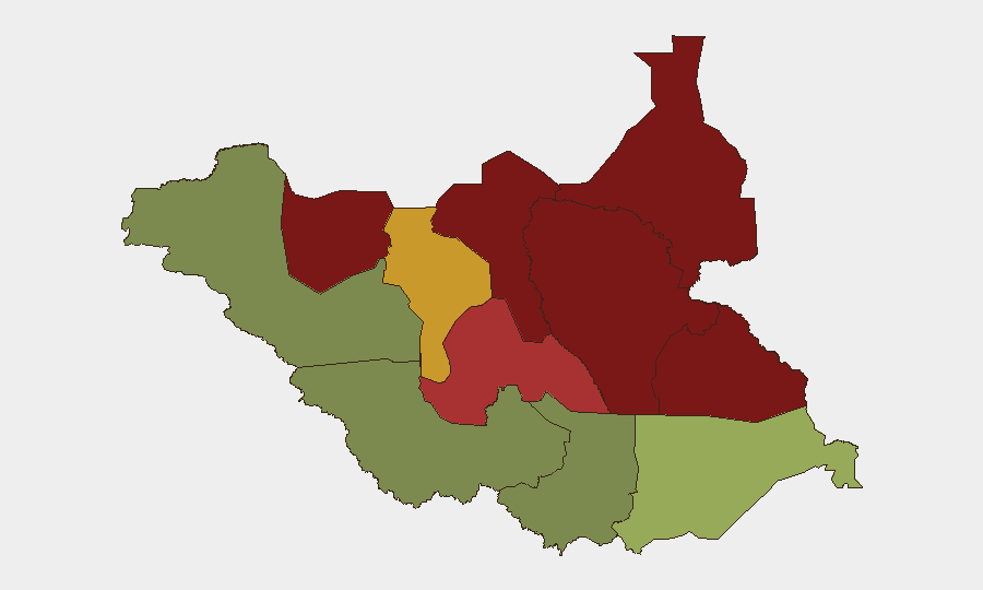
South Sudan remains at composite threat rank #48 globally with a score of 33, reflecting persistent structural instability rather than acute deterioration. No verified security, conflict, or travel-risk incidents have been confirmed in the last 24–48 hours across open-source monitoring. Baseline risk remains elevated in northern and pastoral states (Unity, Jonglei, Upper Nile), driven by inter-communal tensions, cattle raiding, and localized armed-group activity, but no new escalation signals have emerged in the current reporting window.
Key Developments
- No new incidents confirmed in the last 24–48 hours across South Sudan. Open-source wires, regional outlets, NGO situation updates, and social-media OSINT feeds show no clearly dated reports of clashes, major crimes, bombings, or civil unrest within this timeframe that can be independently corroborated.
- Jonglei State baseline remains elevated (risk score 93) due to persistent inter-communal livestock disputes and armed-group presence, but no acute new clashes have been reported since 16 June.
- Northern region (Unity, Upper Nile, Greater Pibor) continues as highest-risk zone (scores 95, 88, 87 respectively), reflecting long-standing pastoralist tensions and militia activity; no discrete new incident reported in current window.
- Western and southern equatorial states (Central Equatoria, Western Equatoria, Western Bahr el Ghazal) show lower composite risk (scores 35, 38, 28), indicating relatively more-stable operating environment for personnel and assets in Juba and border regions.
Highest-Risk Areas
Unity, Jonglei, and Upper Nile states drive South Sudan's risk profile, with composite scores of 95, 93, and 88 respectively. These three regions are characterized by livestock-dependent economies, weak state presence, competing armed groups, and a history of intercommunal violence over pasture and water access. Greater Pibor Administrative Area (87) and Northern Bahr el Ghazal (82) present similar drivers. By contrast, Central Equatoria (35), where the capital Juba is located, and Western Equatoria (38) experience substantially lower risk, though baseline fragility remains. Risk in the northern pastoral belt is structural rather than event-driven; absence of a new incident in the last 48 hours does not indicate a trend reversal.
How GeoBit Would Assist
A corporate security team with personnel or assets in South Sudan should employ AOI Monitoring & Early Warning on Unity, Jonglei, and Upper Nile to detect escalation signals before they affect operations. Intel Sweep and multi-language OSINT fusion (including X/Twitter, Telegram, and regional news aggregation) enable continuous near-real-time tracking of armed-group statements, militia movements, and inter-communal tensions. Battle mapping, force-structure analysis, and entity extraction help teams distinguish localized cattle-raiding incidents from organized conflict escalation. For movement and supply-chain planning, Routing & Network Analysis identifies safer alternative routes and timing windows across high-risk zones.
7-Day Outlook
No acute deterioration is signaled in the 24–48-hour dataset, and baseline risk metrics suggest continued structural stability without new major incidents in the immediate forecast window. However, the June–August dry season traditionally increases inter-communal tensions in pastoral zones as water and forage scarcity drive livestock movement; organizations should maintain heightened AOI monitoring on Jonglei and Unity through early July. Travel to northern states and reliance on cross-border supply routes should remain subject to standard duty-of-care protocols and real-time incident tracking.
Highest-Risk Areas — Ranked
| # | State / Region | Risk |
|---|---|---|
| 1 | Unity | 95 |
| 2 | Jonglei | 93 |
| 3 | Upper Nile | 88 |
| 4 | Greater Pibor Administrative Area | 87 |
| 5 | Northern Bahr el Ghazal | 82 |
| 6 | Lakes | 78 |
| 7 | Warrap | 72 |
| 8 | Ruweng Administrative Area | 68 |
| 9 | Eastern Equatoria | 52 |
| 10 | Western Equatoria | 38 |
| 11 | Central Equatoria | 35 |
| 12 | Western Bahr el Ghazal State | 28 |
Sources
Previous Daily Briefs
A new South Sudan brief is written every day — each with its own risk map and downloadable CSV. Here's the last week; use the calendar to go further back.
📅 Browse every day by calendar →
Highlighted days have a brief. Tap a day for that day's map & analysis, or “csv” for that day's dataset ($5).