Situation Summary
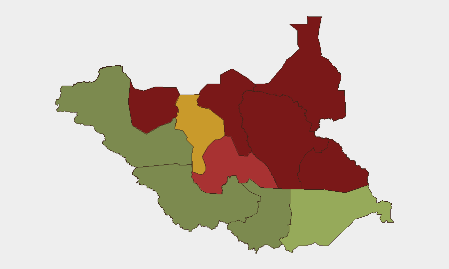
South Sudan remains the 39th highest-risk country globally, with a composite threat score of 49. No tracked security incidents have been recorded in the last 24–48 hours; however, the sub-national risk map shows extreme volatility in northern and eastern states, driven by ongoing inter-communal conflict, armed-group activity, and resource competition. The security environment remains fragmented by region, with the Equatoria belt presenting substantially lower risk than Unity, Jonglei, and Upper Nile. Current trajectory reflects structural instability rather than acute escalation.
Key Developments
No verifiable, time-stamped security incidents have been confirmed for South Sudan in the 24–48 hours ending 20 June 2026. Open-source reporting from major international wire services, regional news desks, and verified social-media accounts contains no clearly dated reports of new violence, civil unrest, armed-group activity, or security events within that window. Reporting in the same period that mentions "South Sudan" primarily addresses regional Sudan conflict dynamics, humanitarian or immigration cases, or advocacy commentary without confirmed on-the-ground incident dates. Responsible threat analysis therefore does not attribute current developments to this briefing period.
*Background context (for duty-of-care awareness):* inter-communal violence and pastoral conflict in northern states (Unity, Jonglei, Upper Nile) have remained endemic throughout H1 2026; however, no new specific incidents are confirmed for 19–20 June.
Highest-Risk Areas
Unity, Jonglei, and Upper Nile states dominate the risk ranking, with composite scores of 95, 93, and 88 respectively. These areas are characterized by fragmented state authority, pastoralist-driven resource competition (cattle, grazing land, water), armed-group presence, and limited security-force capacity. Greater Pibor Administrative Area (risk 87) and Northern Bahr el Ghazal (risk 82) present similar drivers. By contrast, the three Equatoria states (Eastern, Central, and Western) show substantially lower risk scores (52, 35, and 38), reflecting greater administrative presence and lower incidence of organized armed activity. Duty-of-care teams with operations in the north should treat those states as high-consequence zones; southern and southwestern operations face materially lower threat vectors.
How GeoBit Would Assist
Security teams operating in South Sudan should deploy AOI Monitoring & Early Warning on high-risk states (Unity, Jonglei, Upper Nile) to generate automated alerts on emerging incidents, armed-group movement, or conflict signals before media reporting. Conflict & Military tracking (force structure, group positioning, weapons capability) and OSINT fusion (cross-corroborating X/Twitter, Telegram, local radio, and imagery) provide early visibility into inter-communal tensions or armed-group activity. Routing & Network Analysis supports alternative-journey planning around active conflict zones, and GIS & Spatial Analysis refines real-time movement risk by sub-county granularity, enabling dynamic duty-of-care decision-making for personnel and asset movement.
7-Day Outlook
No acute escalation is signaled in the next seven days; however, structural risk in northern states remains high and subject to rapid localized flare-ups around pastoral-cycle events (dry-season grazing pressure, water-point competition) and armed-group activity. Teams should maintain heightened monitoring posture for Unity and Jonglei in particular. Humanitarian access constraints and limited state-security capacity mean incidents, once initiated, spread and persist with limited mitigation by authorities.
Highest-Risk Areas — Ranked
| # | State / Region | Risk |
|---|---|---|
| 1 | Unity | 95 |
| 2 | Jonglei | 93 |
| 3 | Upper Nile | 88 |
| 4 | Greater Pibor Administrative Area | 87 |
| 5 | Northern Bahr el Ghazal | 82 |
| 6 | Lakes | 78 |
| 7 | Warrap | 72 |
| 8 | Ruweng Administrative Area | 68 |
| 9 | Eastern Equatoria | 52 |
| 10 | Western Equatoria | 38 |
| 11 | Central Equatoria | 35 |
| 12 | Western Bahr el Ghazal State | 28 |
Sources
Previous Daily Briefs
A new South Sudan brief is written every day — each with its own risk map and downloadable CSV. Here's the last week; use the calendar to go further back.
📅 Browse every day by calendar →
Highlighted days have a brief. Tap a day for that day's map & analysis, or “csv” for that day's dataset ($5).