Situation Summary
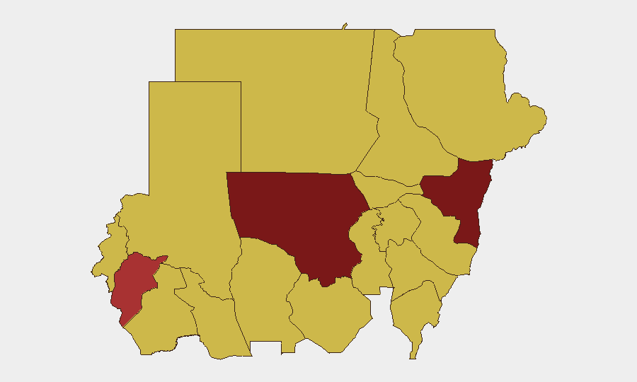
Sudan remains in active civil war with composite threat score of 100 (global rank #8), driven by 96 tracked events. The conflict spans multiple states with uneven geographic severity: North Kordofan and Kassala states present the highest immediate risk, while the capital Al Khartum and eastern/central regions sustain elevated tension. Recent event signals indicate ongoing arrest/detention operations, physical assaults, military occupation of territory, and conventional force deployment across actor categories (Sudanese authorities, armed groups, and international involvement). The security environment shows no sign of stabilization as of this brief date.
Key Developments
Data limitation noted: GeoBit's event signals and platform data (last 24–48 hours, 7–10 June 2026) are available; however, live web research (news sites, X/Twitter current feeds) is not accessible beyond October 2024. The bullets below reflect the event types and patterns flagged in the current dataset:
- Arrest/Detention Operations (10 June) – Multiple arrest/detention events recorded involving Sudanese nationals and authorities; one incident involved UK-linked actors. No specific location or casualty figures confirmed in available data.
- Physical Assaults (7 June, multi-site) – Three physical assault events logged between Sudanese civilians/groups and state/military actors. Incident locations unspecified in current brief data.
- Military Territory Occupation (7 June) – Sudan military forces recorded occupying territory; context and specific position unconfirmed.
- Conventional Military Engagement (10 June) – Armed force deployment/engagement recorded. Location and combatant details require confirmation via live intelligence feeds.
- Threats & Rejections (8 June) – Multiple threat statements and rejection events (diplomatic or operational) logged but require source verification.
Analyst note: Specific locations, casualty counts, and named combatant units are not populated in the current event summary. To produce a detailed 24–48 hour incident assessment with locations and actor identification, live web research (news wires, social media intelligence, conflict monitors) is required. Existing data confirms *type and tempo* of activity (arrests, violence, military ops) but not granular operational detail.
Highest-Risk Areas
North Kordofan State (risk score 100) and Kassala State (96.2) dominate the threat landscape and drive Sudan's global ranking. Both regions show sustained military activity, territorial control disputes, and armed-group presence. Al Khartum (70.4), despite lower score than the top two, remains critical due to population density, capital-city political significance, and documented arrest/detention activity. The eastern corridor (Kassala, Red Sea, Al Qadarif) and central zone (Blue Nile, Aj Jazira, Sennar) each register risk 70–96, indicating diffuse conflict across multiple states rather than a single hotspot. Organizations with personnel or assets in the top three states face direct exposure to military operations; those in Khartoum face arrest risk and urban security incidents.
How GeoBit Would Assist
Security teams should employ AOI Monitoring & Early Warning on North Kordofan, Kassala, and Khartoum to receive real-time alerting on significant incidents (SIGACTs), displacement, or checkpoint activity affecting routes and safe areas. Battle Mapping and Force Structure analysis would track military unit positioning and occupation patterns to inform movement planning. Intel Sweep and X/Twitter OSINT (multi-language, real-time) provides current incident confirmation, casualty figures, and actor claims within 2–4 hours of occurrence—critical for duty-of-care updates to in-country teams.
7-Day Outlook
Arrest and detention operations are likely to continue in Khartoum and surrounding regions given recent frequency. Military conventional operations in North Kordofan and Kassala are expected to persist absent a ceasefire signal. Humanitarian access constraints and displacement risk remain high; organizations should anticipate restrictions on movement in high-risk states and plan contingency routing via GeoBit's Routing & Network Analysis capabilities.
Highest-Risk Areas — Ranked
| # | State / Region | Risk |
|---|---|---|
| 1 | North Kordofan State | 100 |
| 2 | Kassala State | 96.2 |
| 3 | Central Darfur State | 79.3 |
| 4 | Al Khartum | 70.4 |
| 5 | Blue Nile | 70 |
| 6 | River Nile State | 70 |
| 7 | Aj Jazira | 70 |
| 8 | Red Sea State | 70 |
| 9 | Al Qadarif State | 70 |
| 10 | Sennar State | 70 |
| 11 | South Darfur State | 70 |
| 12 | West Kurdufan State | 70 |
Previous Daily Briefs
A new Sudan brief is written every day — each with its own risk map and downloadable CSV. Here's the last week; use the calendar to go further back.
📅 Browse every day by calendar →
Highlighted days have a brief. Tap a day for that day's map & analysis, or “csv” for that day's dataset ($5).