Situation Summary
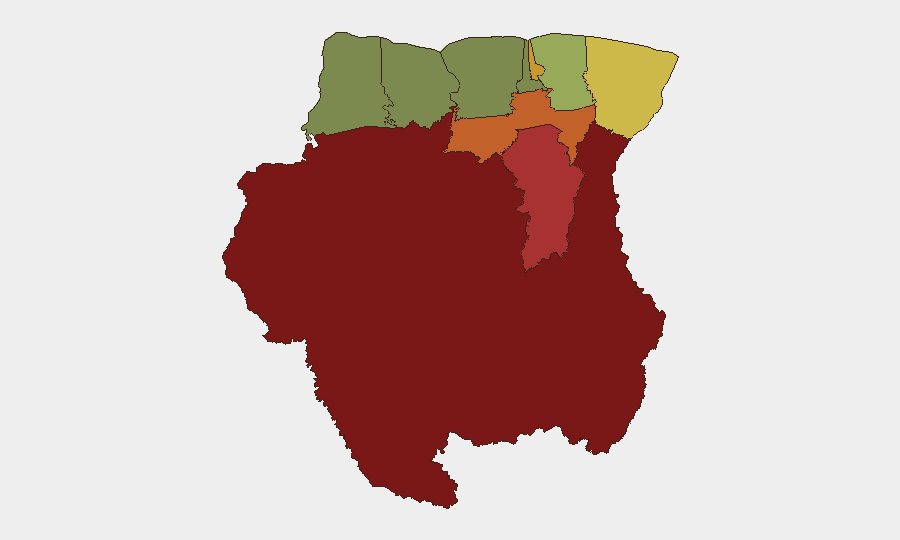
Suriname presents a composite threat profile of 13, placing it outside the top-tier global risk tier. No discrete security incidents have been recorded in the current 24–48 hour monitoring window. The country's risk geography is highly skewed toward remote interior regions, particularly Sipaliwini district, while coastal urban centers remain significantly lower-risk. Overall trajectory remains stable pending verification of any emerging developments.
Key Developments
No verified security, civil-unrest, crime, political-instability, or infrastructure incidents were identified in Suriname during the last 24–48 hours. Web research and open-source monitoring returned no incident-level reports; available references relate to scheduled events (e.g., SEOGS 2026 sports activity in Paramaribo) rather than threat developments. Absence of reported events does not indicate absence of risk—rather, that current monitoring window shows no confirmed escalation or acute incidents.
Highest-Risk Areas
Interior Sipaliwini district (risk 92) and Brokopondo (risk 78) dominate the threat landscape and reflect persistent challenges in remote, sparsely governed jungle terrain characterized by limited state presence, informal economy activity, and cross-border dynamics with Brazil and Guyana. Para (74) and Paramaribo (71) round out the highest-risk tier; Paramaribo's elevated score reflects concentration of urban crime, commercial activity, and population density, while Para's interior location carries similar remote-governance constraints as Sipaliwini and Brokopondo. By contrast, coastal western districts (Nickerie, Coronie, Saramacca) and suburban Wanica cluster at 8–38, indicating materially lower structural risk. Risk concentration in the interior underscores a two-tier security environment: remote regions with governance gaps, and coastal urban/peri-urban zones with conventional crime and service-delivery challenges.
How GeoBit Would Assist
Security teams with personnel or assets in Suriname would employ AOI Monitoring & Early Warning to establish persistent watches on Sipaliwini, Brokopondo, and Paramaribo with automated alerting for incident-level developments. Multi-language OSINT (Intel Sweep, X/Twitter, and Telegram monitoring) combined with entity and network analysis would track criminal and informal-economy actors operating across borders with Brazil and Guyana. Routing & Network Analysis would support duty-of-care teams in planning secure movement corridors between coastal cities and interior operations, and satellite/imagery analysis would provide persistent visibility on infrastructure, border crossing points, and remote settlement activity in high-risk districts.
7-Day Outlook
No acute escalation is anticipated in the near term absent new incident reporting. Structural risks—remote governance, informal cross-border activity, and urban crime in Paramaribo—remain steady-state drivers of the elevated sub-national risk profile. Routine monitoring should continue with emphasis on border regions and interior districts; any verified incident in Sipaliwini or Brokopondo should trigger immediate escalation briefing to duty-of-care teams.
Highest-Risk Areas — Ranked
| # | State / Region | Risk |
|---|---|---|
| 1 | Sipaliwini | 92 |
| 2 | Brokopondo | 78 |
| 3 | Para | 74 |
| 4 | Paramaribo | 71 |
| 5 | Marowijne | 68 |
| 6 | Commewijne | 42 |
| 7 | Wanica | 38 |
| 8 | Saramacca | 29 |
| 9 | Coronie | 12 |
| 10 | Nickerie | 8 |
Previous Daily Briefs
A new Suriname brief is written every day — each with its own risk map and downloadable CSV. Here's the last week; use the calendar to go further back.
📅 Browse every day by calendar →
Highlighted days have a brief. Tap a day for that day's map & analysis, or “csv” for that day's dataset ($5).