Situation Summary
Syria remains the 13th highest-threat country globally (composite score 96.5), driven primarily by ongoing civil war and regional spillover. As of 9 June 2026, the security environment is increasingly shaped by wider Iran–Israel tensions and their direct impact on Syrian airspace, aviation, and border stability. Coordination between Damascus and Beirut on Israeli escalation in Lebanon suggests Syrian leadership is actively monitoring threats to the west and south, with potential for militia and cross-border implications. The conflict trajectory remains volatile, with external actors (Iran, Israel, regional powers) directly affecting Syrian territory and infrastructure.
Key Developments
- Damascus International Airport closure extension (9 June 2026)
Syrian authorities extended suspension of southern air corridors and Damascus International Airport operations until Monday evening, citing security concerns from regional missile threats and Iran–Israel hostilities. This disrupts civil aviation and commercial travel planning.
- Syrian–Lebanese diplomatic engagement on Israeli escalation (9 June 2026)
Syria's Foreign Minister held a call with Lebanon's PM to discuss Israeli military escalation in southern Lebanon and coordinate regional security responses. Signals Damascus concern about spillover risk to western Syria and potential implications for Hezbollah-linked militia activity near the border.
- Temporary Syrian and Iraqi airspace closures (8–9 June 2026)
Both countries closed airspace as a precautionary measure following Iranian missile launches toward Israel. Regional air-defense activity and overflight risk remain elevated; commercial routes requiring Syrian airspace are subject to diversion and delay.
- Military mobilization signal (8 June 2026)
Syrian military mobilization was noted in event tracking, though specific scale and location remain unconfirmed in open sources. Consistent with heightened readiness amid regional tensions.
- Reduction in diplomatic relations with neighbors (8 June 2026)
Signals of reduced relations with Jordan and Iraq were recorded, suggesting broader regional friction and potential tightening of border controls or cross-border movement restrictions.
- Arrest/detention in Aleppo (8 June 2026)
An arrest or detention incident was reported in Aleppo involving a power-sector figure, though details are limited. May indicate internal security concerns or factional tension in the north.
Highest-Risk Areas
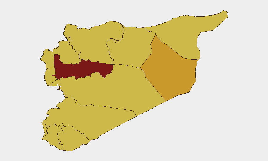
Hama Governorate carries the highest sub-national risk (97.5), significantly above all other regions, driven by active conflict and militia presence. Damascus Governorate (79.7) poses elevated risk due to infrastructure criticality, political sensitivity, and spillover from regional escalation—currently illustrated by airport closures. Deir ez-Zor (71.2) and Aleppo (69.7) remain high-risk due to ISIS residual activity, border instability, and ongoing factional control. The UNDOF buffer zone (67.5) and southern governorates (Dar'a, Al-Quneitra, 67.5 each) face elevated risk from Israeli–Lebanese escalation and cross-border military activity. Western coastal regions (Lattakia, Tartus, 67.5) remain strategically sensitive due to Russian military presence and proximity to Israeli operations.
How GeoBit Would Assist
Security teams should employ AOI Monitoring & Early Warning on high-risk governorates (Hama, Damascus, southern border zones) to detect escalation triggers in real time. Aviation & Maritime Tracking combined with OSINT Fusion (X/Twitter, Telegram, regional news feeds) will provide rapid intelligence on airspace closures, airport status, and alternative routing options for personnel and cargo. Network & Actor Analysis on Damascus-Beirut coordination, Iranian positions, and militia movements offers predictive insight into cross-border risk and regional escalation vectors.
7-Day Outlook
Regional tension is likely to remain elevated through at least mid-week, with airspace restrictions potentially extending beyond the announced Monday closure if Iran–Israel hostilities persist. Border coordination between Syria and Lebanon may increase, raising risk of spillover clashes in western Syria. Commercial aviation disruption should be assumed as the baseline planning assumption for the week ahead.
Highest-Risk Areas — Ranked
| # | State / Region | Risk |
|---|---|---|
| 1 | Hama Governorate | 97.5 |
| 2 | Damascus Governorate | 79.7 |
| 3 | Deir ez-Zor Governorate | 71.2 |
| 4 | Aleppo Governorate | 69.7 |
| 5 | Lattakia Governorate | 67.5 |
| 6 | Tartus Governorate | 67.5 |
| 7 | UNDOF | 67.5 |
| 8 | Al-Quneitra Governorate | 67.5 |
| 9 | Dar'a Governorate | 67.5 |
| 10 | Idleb Governorate | 67.5 |
| 11 | Ar-Raqqa Governorate | 67.5 |
| 12 | Homs Governorate | 67.5 |
Sources
Previous Daily Briefs
A new Syria brief is written every day — each with its own risk map and downloadable CSV. Here's the last week; use the calendar to go further back.
📅 Browse every day by calendar →
Highlighted days have a brief. Tap a day for that day's map & analysis, or “csv” for that day's dataset ($5).