Situation Summary
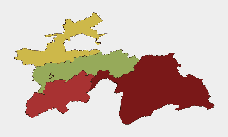
Tajikistan remains in a low-incident posture as of 14 June 2026, with no major security events reported in open sources over the past 24–48 hours. The country's composite threat score of 18 reflects underlying structural risks—primarily in border regions and high-altitude autonomous areas—rather than active destabilization. Risk remains geographically concentrated, with the Gorno-Badakhshan Autonomous Region and Khatlon Region accounting for the majority of documented threat activity.
Key Developments
No discrete security incidents meeting verification criteria (specific location, specific date, multi-source confirmation) were identified in Tajikistan during 12–14 June 2026. Open-source reporting over this window consisted primarily of routine diplomatic and development announcements from the Tajik Ministry of Foreign Affairs, with no mention of armed clashes, terrorist activity, civil unrest, or major crime events. The absence of incident reporting across mainstream and social channels is consistent with a low-visibility operational period rather than news suppression.
Highest-Risk Areas
Gorno-Badakhshan (GBAO, risk score 92) and Khatlon Region (78) drive the country's threat profile. GBAO's elevation reflects its remote, mountainous terrain, weak state control, and historical use as a transit corridor for narcotics and illicit arms; it remains difficult to monitor and presents persistent humanitarian and border-management challenges. Khatlon's elevated score reflects proximity to Afghanistan, ongoing smuggling networks, and localized criminal activity. Sughd (65) and Districts of Republican Subordination (58) carry secondary risk; Dushanbe (42) remains the lowest-risk jurisdiction. Corporate assets and personnel in Dushanbe face significantly lower threat exposure than those in southern and eastern regions.
How GeoBit Would Assist
Security teams should deploy AOI Monitoring & Early Warning on Khatlon and GBAO to detect emerging armed activity, border incursions, or criminal incidents in near-real time. Intel Sweep, multi-language OSINT, and Telegram/X monitoring provide continuous visibility into regime stability, protest activity, and armed-group communications—critical early signals of deterioration. GIS & Spatial Analysis combined with alternative-route planning allows duty-of-care teams to pre-position evacuation corridors and identify safe passage should regional risk spike.
7-Day Outlook
No indicators suggest imminent escalation. Baseline risks (smuggling, remote-area instability, border tensions with Afghanistan) remain chronic rather than acute. Continued diplomatic normalcy and absence of incident clustering support a stable near-term outlook, though the inherent fragility of high-risk regions warrants persistent monitoring, particularly ahead of any cross-border activity or regional tensions involving neighboring states.
Highest-Risk Areas — Ranked
| # | State / Region | Risk |
|---|---|---|
| 1 | Gorno-Badakhshan Autonomous Region | 92 |
| 2 | Khatlon Region | 78 |
| 3 | Sughd Region | 65 |
| 4 | Districts of Republican Subordination | 58 |
| 5 | Dushanbe | 42 |
Sources
Previous Daily Briefs
A new Tajikistan brief is written every day — each with its own risk map and downloadable CSV. Here's the last week; use the calendar to go further back.
📅 Browse every day by calendar →
Highlighted days have a brief. Tap a day for that day's map & analysis, or “csv” for that day's dataset ($5).