Situation Summary
Trinidad and Tobago remains under an active State of Emergency with intensified security operations and elevated enforcement activity across the country. A suspected explosives incident at Piarco International Airport and a significant Coast Guard maritime interdiction on 15 June underscore active threats in aviation and maritime domains. The Government has charged 698 individuals under SoE provisions, signalling sustained law-enforcement pressure, though the Police Service faces operational constraints due to inherited debt; labour unions are mobilizing against new protest restrictions, introducing civil-unrest risk alongside traditional crime and security threats.
Key Developments
- Piarco International Airport (Port of Spain) – 15 June 2026: An inbound aircraft reported to be "filled with explosives" triggered a national security alert and emergency response. Security agencies cordoned and inspected the aircraft and cargo; outcome of inspection not yet confirmed in available reporting.
- South Coast of Trinidad – 15 June 2026: Trinidad and Tobago Coast Guard and Defence Force intercepted a vessel suspected of illegal maritime activity in a joint operation, indicating ongoing illicit trafficking or smuggling pressure in territorial waters.
- Nationwide – 15 June 2026: The Minister of Homeland Security confirmed that 698 individuals have been charged under current State of Emergency provisions, reflecting intensified enforcement across multiple jurisdictions and crime categories.
- Nationwide – 15 June 2026: The Police Service reported structural capacity constraints, with an inherited TT$500 million debt limiting equipment procurement and sustainability of current crime-fighting and SoE enforcement operations.
- Nationwide – circulating 15–16 June 2026: The Joint Trade Union Movement is demanding withdrawal of new State of Emergency regulations establishing 50 no-protest zones across Trinidad, signalling potential labour unrest and civil-liberties mobilization if restrictions remain.
- Attorney General and Senate – 16 June 2026: Multiple public statements and disapprovals between the Attorney General and Senate suggest institutional friction over SoE governance or judicial/law-enforcement policy, potentially affecting coordination and public confidence in the security response.
Highest-Risk Areas
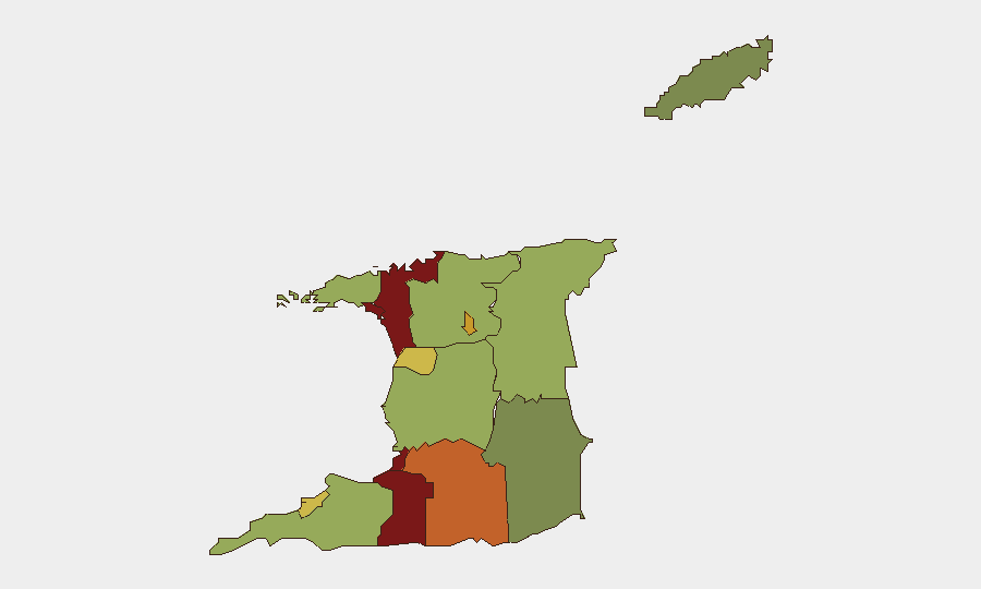
San Juan–Laventille (risk 95) and Port of Spain (risk 88) are the highest-threat sub-national zones, likely reflecting persistent gang activity, drug trafficking, and homicide concentration in the capital region. Penal–Debe (82), San Fernando (80), and Princes Town (75) form a southern corridor of elevated risk, consistent with historical smuggling routes, illicit narcotics distribution, and organized crime networks. The clustering of highest-risk areas in western and central Trinidad indicates that security interventions, SoE enforcement, and supply-chain interdiction should prioritize these zones; lower-risk areas (Sangre Grande, Couva–Tabaquite–Talparo, Diego Martin) suggest that dispersed crime and civil disorder are not evenly distributed.
How GeoBit Would Assist
Security teams should deploy AOI Monitoring & Early Warning on Piarco International Airport, Port of Spain docks, and the south-coast maritime zone to detect recurrence of aviation or maritime threats. OSINT fusion (X/Twitter, local news, radio SIGINT) combined with Network & Actor Analysis would track labour-union mobilization, SoE-related institutional tensions, and enforcement operations in real time. Maritime tracking and GIS & Spatial Analysis would support interdiction planning and risk assessment across the highest-threat sub-national regions (San Juan–Laventille, Port of Spain, Penal–Debe).
7-Day Outlook
The SoE is likely to remain in effect with continued enforcement sweeps and mass charging, increasing operational strain on the Police Service unless debt and equipment gaps are addressed. Labour unrest over protest restrictions poses near-term mobilization risk; any escalation could coincide with ongoing security operations, complicating public order. Aviation and maritime security operations will remain elevated; recurrence of explosives or trafficking incidents cannot be ruled out given the frequency of recent detections.
Highest-Risk Areas — Ranked
| # | State / Region | Risk |
|---|---|---|
| 1 | San Juan-Laventille | 95 |
| 2 | Port of Spain | 88 |
| 3 | Penal-Debe | 82 |
| 4 | San Fernando | 80 |
| 5 | Princes Town | 75 |
| 6 | Arima | 72 |
| 7 | Chaguanas | 68 |
| 8 | Point Fortin | 65 |
| 9 | Diego Martin | 58 |
| 10 | Siparia | 55 |
| 11 | Couva-Tabaquite-Talparo | 52 |
| 12 | Sangre Grande | 48 |
Sources
Previous Daily Briefs
A new Trinidad and Tobago brief is written every day — each with its own risk map and downloadable CSV. Here's the last week; use the calendar to go further back.
📅 Browse every day by calendar →
Highlighted days have a brief. Tap a day for that day's map & analysis, or “csv” for that day's dataset ($5).