Situation Summary
Trinidad and Tobago faces a composite threat level of 14 globally, with five tracked security events in the current reporting cycle. The last 24–48 hours have yielded no confirmed, cross-corroborated security incidents available via public reporting; however, recent event signals suggest underlying tensions involving police statements and industry-military force interactions dated 17–18 June. The security landscape remains characterized by concentrated risk in urban corridors, particularly the northern and central regions, with no immediate escalation detected but continued volatility in high-risk zones.
Key Developments
- Police Public Statement (18 June, location unconfirmed): Trinidad and Tobago Police Service issued a public statement; specific subject matter and geographic focus not yet clarified in available reporting.
- Bilateral Military-Industry Incidents (17 June, location unconfirmed): Two separate conventional military force interactions were recorded—one involving Trinidad and Tobago government vs. industry, a second involving industry vs. government—suggesting resource, regulatory, or security dispute unresolved.
- Government Statement (17 June, location unconfirmed): Trinidad and Tobago issued a public statement in connection with the above incidents; full text and intent not yet available in open sources.
Note: No additional security-relevant developments (crime spikes, civil unrest, infrastructure disruption, or travel incidents) have been confirmed in the last 24–48 hours via live web research. Further detail on the three event signals above requires local news or official government corroboration.
Highest-Risk Areas
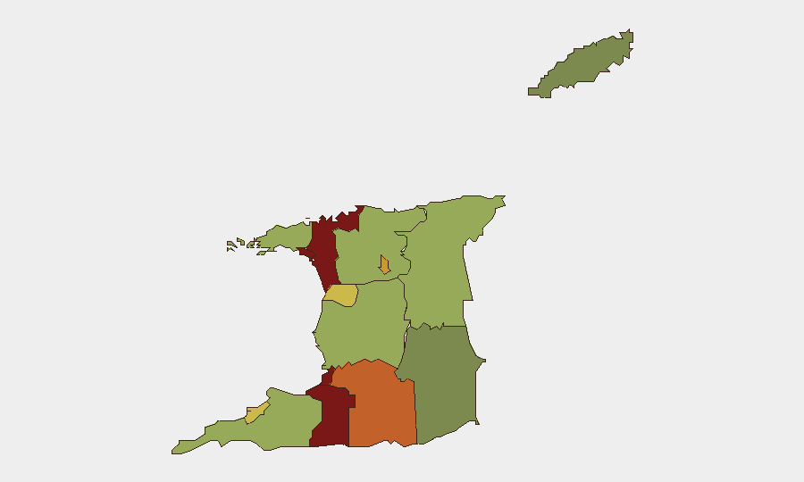
San Juan-Laventille (risk 95) and Port of Spain (risk 88) account for the most acute sub-national threat exposure, followed by Penal-Debe (82) and San Fernando (80). These northern and central urban zones have historically registered elevated conventional crime, gang activity, and public-order risk. Mid-tier risk areas including Princes Town, Arima, and Chaguanas show sustained concern, while southern and eastern regions (Point Fortin, Siparia, Sangre Grande, Couva-Tabaquite-Talparo) carry lower but still notable risk profiles. Concentration of risk in urban centers with large transient populations and known gang presence suggests that corporate assets, personnel transit routes, and supply-chain nodes in Port of Spain and San Fernando warrant priority duty-of-care review.
How GeoBit Would Assist
Security teams should deploy AOI (Area of Interest) Monitoring & Early Warning on Port of Spain, San Juan-Laventille, and San Fernando to capture incident alerts in real time. OSINT fusion across local police reports, X/Twitter feeds, and Telegram channels will clarify the substance of the three 17–18 June event signals and track follow-up developments. Risk & Threat Assessment can be refreshed daily to flag any escalation in the military-industry dispute or spike in police activity that may signal broader instability or supply-chain disruption.
7-Day Outlook
No imminent escalation is indicated, but the unresolved military-industry incidents and recent police statement warrant close monitoring. If the 17 June conflict involves port, energy, or critical infrastructure, secondary effects (delays, security controls, personnel restrictions) may emerge within 5–7 days. Recommend heightened situational awareness in Port of Spain and northern zones pending official clarification of the recent incidents.
Highest-Risk Areas — Ranked
| # | State / Region | Risk |
|---|---|---|
| 1 | San Juan-Laventille | 95 |
| 2 | Port of Spain | 88 |
| 3 | Penal-Debe | 82 |
| 4 | San Fernando | 80 |
| 5 | Princes Town | 75 |
| 6 | Arima | 72 |
| 7 | Chaguanas | 68 |
| 8 | Point Fortin | 65 |
| 9 | Diego Martin | 58 |
| 10 | Siparia | 55 |
| 11 | Couva-Tabaquite-Talparo | 52 |
| 12 | Sangre Grande | 48 |
Sources
Previous Daily Briefs
A new Trinidad and Tobago brief is written every day — each with its own risk map and downloadable CSV. Here's the last week; use the calendar to go further back.
📅 Browse every day by calendar →
Highlighted days have a brief. Tap a day for that day's map & analysis, or “csv” for that day's dataset ($5).