Situation Summary
Ukraine remains at composite threat level 3 globally with 441 tracked events, driven by active conventional military operations across multiple fronts. Russian and Ukrainian forces continue intensive kinetic activity, with recent signals indicating sustained artillery, drone, and small-arms engagement across eastern and central regions. Diplomatic posturing and threats from multiple actors suggest heightened tension alongside ongoing combat operations. The security environment shows no signs of de-escalation over the reporting period.
Key Developments
- Overnight drone attack, Kherson region (2026-06-04): Ukrainian unmanned systems targeted an FSB facility in Russian-occupied Kherson Oblast, resulting in confirmed explosions and structural damage to the installation.
- Russian multi-location strikes (2026-06-03 to 2026-06-04): Distributed Russian airstrikes and artillery across Ukraine killed at least 8 civilians and wounded approximately 50+ over the last 24 hours; specific strike locations not yet fully corroborated across independent sources.
- Diplomatic threat signal (2026-06-02): Unspecified diplomat issued threat communication against Ukrainian officials or state actors; context and parties involved require further clarification from source verification.
- Military rejection and public statement (2026-06-02 to 2026-06-03): Ukrainian military command issued public statement and rejection of military-related communication or proposal; content and implications remain under analysis.
- Small-arms and artillery engagement (2026-06-02): Active small-arms combat reported between Ukrainian and Russian forces; concurrent artillery/tank engagements documented in eastern sectors.
- Ukrainian threat communication (2026-06-02): Ukrainian authorities or military issued threat statement directed at Moscow-affiliated targets; specific content not yet cross-referenced.
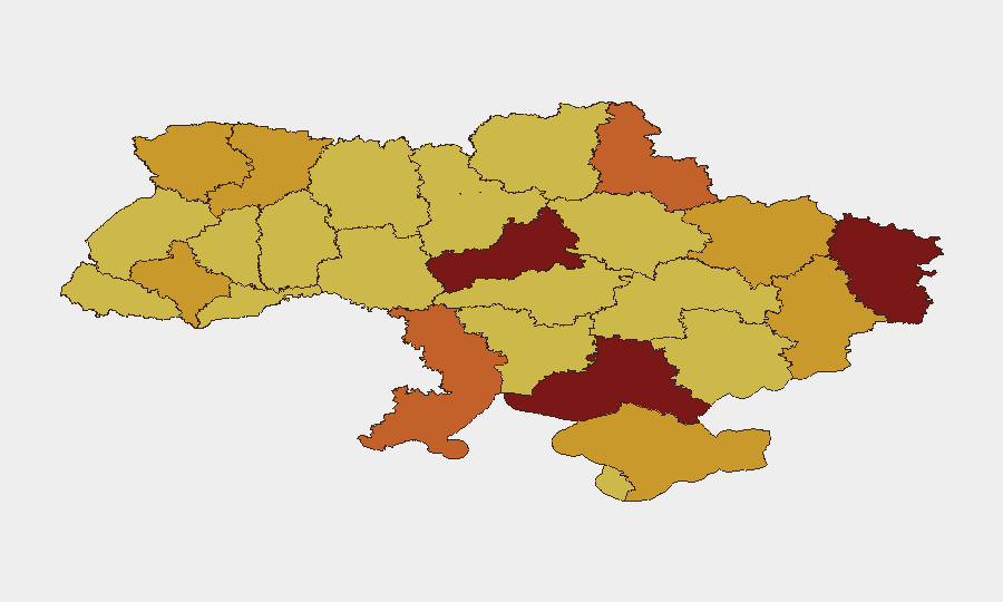
Highest-Risk Areas
Cherkasy Oblast (risk 100) and Kyiv (risk 95.7) dominate the current threat landscape, followed by a cluster of eastern and central regions—Luhansk, Kherson, and Sumy oblasts—each scoring 73–83. The concentration of highest risk in Cherkasy and Kyiv reflects both proximity to active combat zones and vulnerability to drone strikes, artillery standoff, and potential escalation toward civilian infrastructure. Eastern oblasts (Luhansk, Kherson, Donetsk) remain contested or occupied zones with persistent kinetic activity. Odesa and southern coastal regions (Kherson, Crimea) face additional maritime and cross-border threat vectors.
How GeoBit Would Assist
Security teams operating in Ukraine should deploy Intel Sweep and OSINT fusion to corroborate current strike locations, casualty counts, and military posture changes in real time. AOI Monitoring with alerting on Cherkasy, Kyiv, and eastern oblasts would provide persistent early warning of new kinetic events, infrastructure threats, or population displacement. Conflict & Military battle mapping, satellite imagery analysis, and alternative routing & network analysis enable rapid assessment of ground movement, checkpoint status, and safe transit corridors—critical for duty-of-care decisions on personnel movement and asset protection.
7-Day Outlook
Russian and Ukrainian operations are expected to continue at current tempo or intensify, with particular pressure on central and eastern sectors. Drone attacks and artillery strikes will likely remain distributed across multiple oblasts; civilian exposure remains elevated. No negotiation signals suggest imminent ceasefire; security teams should plan for sustained elevated threat through at least 7–10 June.
Highest-Risk Areas — Ranked
| # | State / Region | Risk |
|---|---|---|
| 1 | Cherkasy Oblast | 100 |
| 2 | Kyiv | 95.7 |
| 3 | Luhansk Oblast | 82.8 |
| 4 | Kherson Oblast | 80.7 |
| 5 | Odesa Oblast | 74.1 |
| 6 | Sumy Oblast | 73.9 |
| 7 | Kharkiv Oblast | 72.3 |
| 8 | Donetsk Oblast | 72.1 |
| 9 | Autonomous Republic of Crimea | 72.1 |
| 10 | Rivne Oblast | 72 |
| 11 | Volyn Oblast | 71.8 |
| 12 | Ivano-Frankivsk Oblast | 71.1 |
Previous Daily Briefs
A new Ukraine brief is written every day — each with its own risk map and downloadable CSV. Here's the last week; use the calendar to go further back.
📅 Browse every day by calendar →
Highlighted days have a brief. Tap a day for that day's map & analysis, or “csv” for that day's dataset ($5).