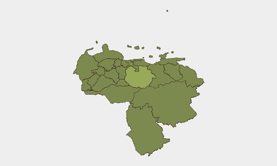
Situation Summary
Venezuela remains a high-risk operating environment (#32 globally) characterized by political instability, armed group activity, and localized territorial disputes. Recent event signals point to military mobilization, inter-institutional tensions, and international diplomatic friction, though ground-level incident confirmation in the last 48 hours remains limited in open-source reporting. Conditions favor continued volatility in high-risk northern and central states, with cascading effects on corporate operations and personnel security in Caracas and industrial zones.
Key Developments
- 2026-06-14 · Caracas/National Level: Multiple conventional military force events reported involving Venezuelan state military; specific operational details and geographic concentration not yet corroborated by independent media. Suggests heightened force readiness or internal repositioning.
- 2026-06-14 · Unspecified Territorial Flashpoint: Occupation-of-territory signal between Venezuelan armed actors (likely criminal or irregular militia groups) indicates renewed localized territorial contest; specific municipality not yet confirmed in reliable reporting.
- 2026-06-14 · Venezuela–U.S. Bilateral: Conventional military force event attributed to Venezuela–U.S. domain; rhetoric rather than kinetic activity most likely, but signals heightened political-military tension with external dimension.
- 2026-06-12 · Caracas/Presidential Level: Corporate arrest/detention event linked to presidential authority; suggests targeting of foreign or private-sector entities by state apparatus. Details and company identity require further corroboration.
- 2026-06-12 · National-Level Investigation: United Kingdom and Venezuelan authorities initiated investigations into unspecified matter; possible commercial, sanctions-evasion, or transnational crime angle. Low immediate operational impact if regulatory.
Note: Open-source reporting for the last 48 hours is fragmented. Signals are tracked but lack granular incident confirmation. Corporate teams should anticipate delayed or spotty news flow from Venezuela and rely on direct asset/personnel reporting and intelligence subscription updates.
Highest-Risk Areas
Guarico State (57.8) and the Federal District—Caracas metro area (45.9)—drive the composite risk score and warrant priority monitoring. Guarico's rural position and limited state presence make it a persistent ungoverned or disputed-control zone favorable to criminal and irregular militia activity. The Federal District's concentration of government, finance, and foreign corporate assets creates overlapping risks: state targeting of foreign entities, kidnapping/extortion, and collateral spillover from inter-agency or political-security faction friction. Secondary concern: Aragua (34.6), a long-standing stronghold for transnational organized crime and irregular armed groups (historically Tren de Aragua), which poses direct threat to supply chains and personnel transit in northern industrial corridors.
How GeoBit Would Assist
Security teams should deploy AOI Monitoring & Early Warning on Caracas, Guarico, and Aragua to flag new violence, roadblocks, or force deployments in real time. OSINT fusion (X/Telegram, news feeds, radio SIGINT) and network & actor analysis are critical to disambiguate military posture shifts, faction infighting, and cartel territorial moves from political noise. Routing & network analysis enables rapid alternative-route planning for personnel and supply movements if primary corridors (e.g., coastal highways, Guarico transit) become unsafe.
7-Day Outlook
Military and political signals suggest continued internal pressure on the government and possible escalation of factional or criminal-group territorial contest in uncontrolled areas. Corporate and expat communities should expect operational disruption in Caracas and Aragua state over the coming week; banking, telecom, and fuel availability may be subject to state action or supply-chain interruption. Vigilant personnel reporting and real-time asset tracking are essential.
Highest-Risk Areas — Ranked
| # | State / Region | Risk |
|---|---|---|
| 1 | Guarico State | 57.8 |
| 2 | Federal District | 45.9 |
| 3 | Aragua State | 34.6 |
| 4 | Monagas State | 31.8 |
| 5 | Sucre State | 31.2 |
| 6 | Merida State | 29.6 |
| 7 | Anzoategui State | 29.5 |
| 8 | Carabobo State | 29.3 |
| 9 | Vargas State | 28.4 |
| 10 | Barinas State | 28.1 |
| 11 | Zulia State | 27.9 |
| 12 | Tachira State | 27.9 |
Previous Daily Briefs
A new Venezuela brief is written every day — each with its own risk map and downloadable CSV. Here's the last week; use the calendar to go further back.
📅 Browse every day by calendar →
Highlighted days have a brief. Tap a day for that day's map & analysis, or “csv” for that day's dataset ($5).