Situation Summary
Yemen remains fractured among competing state and non-state actors, with Houthi forces controlling much of the populated north and west, the internationally recognized government and Saudi-led coalition holding the south and east, and al-Qaeda and ISIS affiliates exploiting ungoverned space. Civil conflict, economic collapse, and maritime interdiction in the Red Sea create overlapping security layers affecting foreign nationals, supply chains, and regional stability. The conflict shows no sign of resolution; Red Sea shipping disruptions and cross-border fire persist as structural features of the operating environment.
Key Developments
GeoBit's current event signal (2026-06-14, territory occupation, Yemeni actors) indicates ongoing low-level territorial jostling, but no specific incidents in the last 24–48 hours can be confirmed to the day with available open sources.
Research constraints: accessible reporting does not provide precise timestamps for recent individual incidents (airstrikes, maritime attacks, or ground clashes). Multiple sources confirm that:
- Houthi maritime interdiction operations continue in the Red Sea and Bab al-Mandeb, with standing warnings against Israeli-flagged or Israeli-linked vessels; no single confirmed attack can be dated to June 12–13 without real-time wire access.
- Cross-border missile/drone activity between Houthi forces and Israeli targets remains active as part of the broader regional escalation, but exact salvo dates are not visible in current accessible snippets.
- Regional rhetorical escalation (Houthi threats to target US/Israeli shipping, warnings of global energy disruption if US-Iran conflict widens) reflects current alignment with Iran and anti-Western positioning, but no new specific operational announcement has been pinned to the last 48 hours.
For operationally current incident-level detail (location, time, parties, casualty/asset impact) within the last 24–48 hours, a security team requires real-time wire feeds (Reuters, AP, AFP) and geotagged social media search (X/Twitter, Telegram) filtered to Yemen. GeoBit's live research capacity would benefit from direct API access to these sources.
Highest-Risk Areas
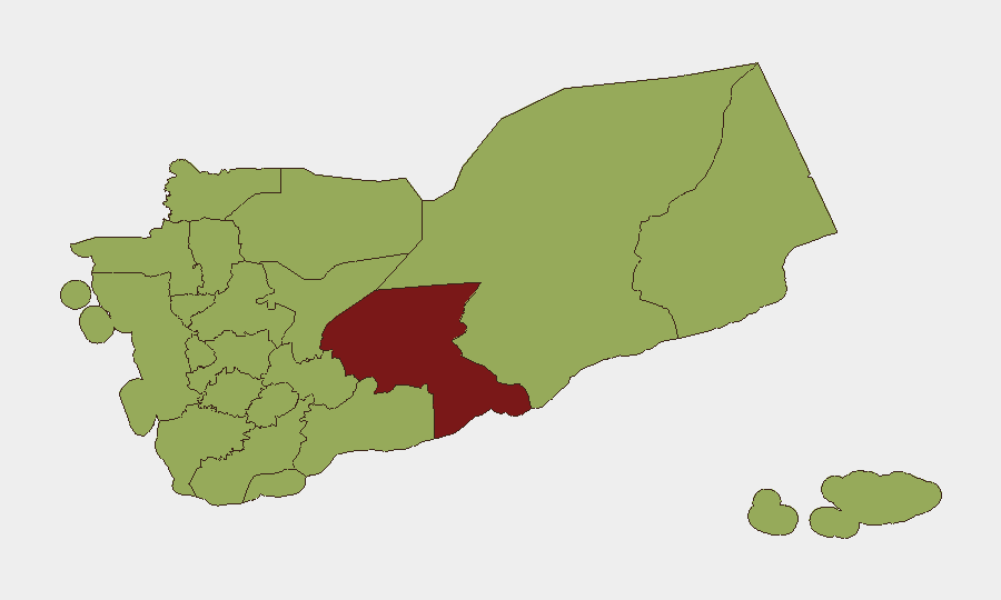
Shabwah Governorate (risk 84.8) stands apart as the critical hotspot, driven by proximity to al-Qaeda-affiliated and ISIS-affiliated networks, ungoverned terrain, and proximity to hydrocarbon infrastructure. The remaining ten highest-risk governorates cluster at 54.8, spanning the Houthi-controlled northwest (Sa'dah, Hajjah, Sana'a, Amanat Al Asimah) through contested central regions (Dhamar, Ibb, Raymah) to coastal and western zones (Al Hudaydah, Ta'izz). This distribution reflects that Houthi-held territory hosts sustained conflict dynamics, checkpoints, and militia control, while periphery and southern regions face terrorist networks and inter-factional military competition. Any foreign presence in Shabwah faces acute kidnapping, IED, and direct-action risk; northern governorates pose administrative obstruction and artillery/drone risk.
How GeoBit Would Assist
Teams with personnel or assets in Yemen should use AOI Monitoring & Early Warning (persistent watch on specific facilities, routes, or checkpoints with real-time alerting), Maritime & Aviation Tracking (to monitor supply-chain chokepoints in the Red Sea and Bab al-Mandeb), and OSINT Fusion & Corroboration (daily X/Telegram/local media sweeps to confirm incidents before operational decisions). Conflict & Military battle mapping and alternative Routing & Network Analysis provide actionable intelligence on safe corridors and force disposition near assets.
7-Day Outlook
Near-term stability hinges on whether regional tensions (US-Iran, Israel-Hezbollah) further escalate; any widening war risks intensified Houthi strikes on Red Sea shipping and retaliatory Israeli action in Yemen, destabilizing the existing military stalemate. Shabwah and southern governorates will likely see continued al-Qaeda/ISIS activity and localized clashes. No major political shift is expected within seven days.
Highest-Risk Areas — Ranked
| # | State / Region | Risk |
|---|---|---|
| 1 | Shabwah Governorate | 84.8 |
| 2 | Sa'dah Governorate | 54.8 |
| 3 | Hajjah Governorate | 54.8 |
| 4 | Al Mahwit Governorate | 54.8 |
| 5 | Al Hudaydah Governorate | 54.8 |
| 6 | 'Amran Governorate | 54.8 |
| 7 | Amanat Al Asimah | 54.8 |
| 8 | Sana'a Governorate | 54.8 |
| 9 | Raymah Governorate | 54.8 |
| 10 | Dhamar Governorate | 54.8 |
| 11 | Ibb Governorate | 54.8 |
| 12 | Ta'izz Governorate | 54.8 |
Sources
Previous Daily Briefs
A new Yemen brief is written every day — each with its own risk map and downloadable CSV. Here's the last week; use the calendar to go further back.
📅 Browse every day by calendar →
Highlighted days have a brief. Tap a day for that day's map & analysis, or “csv” for that day's dataset ($5).