Situation Summary
Bahamas maintains a composite threat score of 18 (global rank #67), with no major security incidents tracked in the past 24–48 hours. The primary recent event is a fatal aviation accident on Friday, July 10, affecting intra-island transport and one regional carrier. Overall security posture remains stable, though sub-national risk concentrations in New Providence and Freeport warrant continued monitoring of crime and operational disruptions.
Key Developments
- North Andros Island – Friday, July 10, 2026 – Fatal Cessna 402 crash
A Flamingo Air Cessna 402 (C6-FLX) crashed near North Andros Airport, killing all 10 occupants, including musicians and a DJ. Bahamian aviation authorities temporarily suspended Flamingo Air's Air Operator Certificate pending investigation, directly reducing inter-island connectivity.
- Aviation authority response – Friday–Saturday, July 10–11, 2026
Temporary grounding of Flamingo Air operations continues to disrupt scheduled regional flights and passenger movement across the archipelago. Investigation and victim identification efforts remain ongoing.
- Government and police statements – July 11–12, 2026
Public statements from police and the Prime Minister's office have addressed the incident. No secondary security implications or civil unrest have been documented as of the reporting window.
Highest-Risk Areas
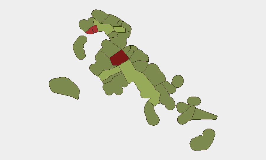
New Providence (risk 92) and the City of Freeport (risk 78) are the dominant drivers of sub-national risk, reflecting concentrated populations, economic activity, and known crime prevalence in Nassau and Freeport respectively. Central Abaco (risk 52) presents elevated secondary risk. The remainder of the archipelago—including South Andros, North Abaco, and the outer islands—carries substantially lower individual risk scores (28–38), though cumulative operational dependencies on inter-island transport, supply chains, and emergency services create archipelago-wide fragility. Corporate assets and personnel should prioritize situational awareness in New Providence and Freeport, while maintaining backup communication and logistics plans given the recent aviation disruption.
How GeoBit Would Assist
Security teams should deploy AOI Monitoring & Early Warning on New Providence and Freeport to detect emerging crime, civil unrest, or operational disruptions in real time. Maritime & Aviation tracking capabilities would support contingency routing and travel planning during carrier disruptions (as demonstrated by the Flamingo Air grounding). Intel Sweep and multi-language OSINT fusion across local government statements, police releases, and media sources would enable rapid identification of secondary incidents—civil unrest, supply-chain breaks, or security force responses—that could affect duty of care and asset protection.
7-Day Outlook
The aviation accident and temporary Flamingo Air suspension are likely to persist for 5–7 days pending initial investigation closure and regulatory clearance. No indication of civil unrest or secondary security deterioration is evident. Recommend maintaining heightened awareness in New Providence and Freeport for any crime or operational incidents that could compound transport disruptions; routine monitoring of outer-island connectivity is advisable for supply-chain continuity.
Highest-Risk Areas — Ranked
| # | State / Region | Risk |
|---|---|---|
| 1 | New Providence | 92 |
| 2 | City of Freeport | 78 |
| 3 | Central Abaco | 52 |
| 4 | Central Andros | 48 |
| 5 | Exuma | 45 |
| 6 | East Grand Bahama | 42 |
| 7 | South Andros | 38 |
| 8 | North Abaco | 35 |
| 9 | North Eleuthera | 33 |
| 10 | South Abaco | 32 |
| 11 | Cat Island | 30 |
| 12 | Mangrove Cay | 28 |
Sources
Previous Daily Briefs
A new Bahamas brief is written every day — each with its own risk map and downloadable CSV. Here's the last week; use the calendar to go further back.
📅 Browse every day by calendar →
Highlighted days have a brief. Tap a day for that day's map & analysis, or “csv” for that day's dataset ($5).
Atlas — our AI intelligence desk — emails them this snapshot personally. Nothing else, no list.