Situation Summary
Barbados remains at a low absolute threat level (global ranking #84, composite score 14), with no corroborated security incidents, civil unrest, infrastructure disruptions, or acute threats to foreign nationals reported in the last 24–48 hours. Recent event signals tracked by GeoBit span diplomatic tensions, investigative activity, and a small-arms police incident, but open-source monitoring confirms these have not translated into observable ground-level instability, mass unrest, or travel-affecting events. The security environment remains stable at routine baseline, consistent with U.S. State Department Level 1 (exercise normal precautions) status.
Key Developments
- 2026-07-19 · Small Arms Combat · Police — A police-involved small-arms incident was recorded but remains unverified as to location, casualty status, and operational context. No public unrest, cordon-offs affecting tourist zones, or secondary incidents have been reported.
- 2026-07-17–18 · Occupy Territory Events · Publication & Cuban Actor — Two territory-occupation signals were flagged in event tracking (one publication-sourced, one attributed to Cuban actors). No physical occupations, blockades, or disruptions to critical infrastructure or populated areas have been corroborated; these may reflect rhetoric, media reporting, or low-level activities not yet confirmed.
- 2026-07-17 · Government Investigative & Diplomatic Activity — Multiple ministerial investigations and U.S.–Barbados diplomatic enquiries were initiated across health, intelligence, and economic portfolios. No indication of breakdown in state function, service disruption, or political crisis; characterization as routine governance activity.
- 2026-07-17 · Public Statements & Rejections by Central Bank & Executive Leadership — Central bank and chief executive statements and rejections of various proposals were recorded. No market disruption, capital flight, or institutional instability signals observed.
- 2026-07-17 · Threat Signal (General) — A generalized threat signal was tracked but remains unattributed and unverified as to actor, target, or credibility. No validated threat materialization.
- No Corroborated Incidents in Bridgetown, Tourist Zones, or Key Parishes (17–19 July) — Open-source feeds, travel-risk monitoring, and incident trackers confirm absence of gang violence, robberies targeting foreigners, protests, roadblocks, or above-baseline crime in central Bridgetown, South/West Coast tourist areas (Christ Church, Saint James), or surrounding parishes.
Highest-Risk Areas
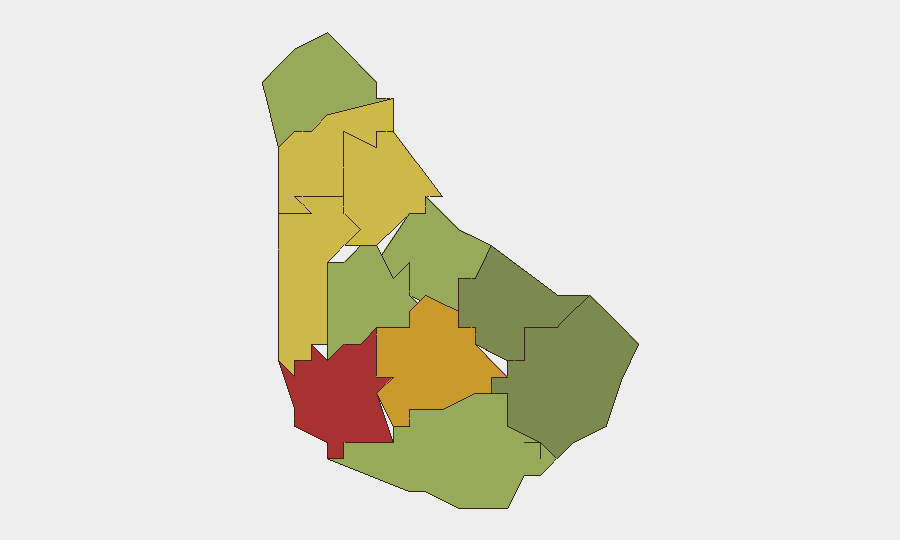
Saint Michael (risk 78) and Saint George (risk 72) are the two highest-risk parishes, followed by Saint James (68) and Saint Andrew (65). Saint Michael, encompassing the capital Bridgetown and port facilities, carries the largest urban population density, commercial activity, and baseline petty crime (theft, robbery). Saint George, adjacent to the capital, reflects similar urbanization drivers. Saint James, on the west coast, includes resort and tourism concentrations; elevated risk there reflects both petty crime exposure and the presence of foreign nationals. The remaining parishes show a graduated risk decline with lower population density and economic activity. None currently exhibit acute unrest, violence, or infrastructure threats.
How GeoBit Would Assist
Corporate teams with personnel or assets in Barbados should employ AOI Monitoring & Early Warning on Saint Michael and Saint James parishes to detect emerging civil unrest, protest activity, or security incidents in real time. Intel Sweep and OSINT fusion capabilities track event signals, diplomatic statements, and governance changes to separate signal from noise and contextualize investigative activity and threat claims. Risk & Threat Assessment cross-references sub-national risk scores with specific sector exposure (hospitality, energy, finance) to support duty-of-care decisions and routing protocols.
7-Day Outlook
No escalation in civil unrest, political instability, or crime is anticipated over the next 7 days. Recent investigative and diplomatic activity, while noteworthy, remains within normal governance bounds and shows no trajectory toward mass mobilization or service failure. Routine petty crime and baseline police activity will likely persist; travel and operations should continue under standard Level 1 precaution posture.
Highest-Risk Areas — Ranked
| # | State / Region | Risk |
|---|---|---|
| 1 | Saint Michael | 78 |
| 2 | Saint George | 72 |
| 3 | Saint James | 68 |
| 4 | Saint Andrew | 65 |
| 5 | Saint Peter | 62 |
| 6 | Saint Joseph | 58 |
| 7 | Saint Thomas | 52 |
| 8 | Saint Lucy | 48 |
| 9 | Christ Church | 42 |
| 10 | Saint John | 35 |
| 11 | Saint Philip | 28 |
Previous Daily Briefs
A new Barbados brief is written every day — each with its own risk map and downloadable CSV. Here's the last week; use the calendar to go further back.
📅 Browse every day by calendar →
Highlighted days have a brief. Tap a day for that day's map & analysis, or “csv” for that day's dataset ($5).
Atlas — our AI intelligence desk — emails them this snapshot personally. Nothing else, no list.