Situation Summary
Belize remains in a stable but persistently elevated-risk environment driven by structural gang violence and armed crime rather than acute political or civil unrest. No new, clearly verified security incidents have been documented in the past 24–48 hours; however, the underlying threat from organized crime—particularly in Belize City and Orange Walk District—continues to sustain country-level risk. The government's ongoing State of Emergency and intensified police operations reflect an attempt to contain rather than resolve chronic criminal activity.
Key Developments
- No new discrete security incidents confirmed in Belize for the past 24–48 hours across monitored open-source feeds, local media, and corroborated reporting (as of 2026-07-21, 06:00 UTC).
- Belize District & Belize City (mid-July, ongoing): Government State of Emergency and targeted gang-crime operations remain active; police deployments and enforcement actions continue without reported new clashes or arrests in the immediate 24–48-hour window.
- Orange Walk District – Blue Creek (timing unclear, recent): A crop-duster aircraft crash with minor pilot injury was reported; civil aviation authorities have initiated accident investigation.
- Orange Walk District – San Lazaro (earlier this week, outside 24–48-hour window): Police charged a suspect in the chopping death of a 68-year-old farmer; case highlights rural violent-crime risk in the district.
- Belize City – Belchina Bridge incident (early July, outside 24–48-hour window): A serious shooting resulted in recovery of ~30 shell casings and police operations to prevent retaliation; demonstrates ongoing firearm violence in the capital.
- Structural threat context (since Q2 2026): Gang violence, armed robbery, and trafficking-related conflict remain endemic; no indication of de-escalation in underlying criminal activity.
Highest-Risk Areas
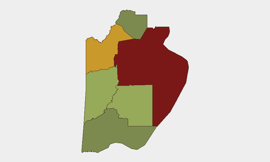
Belize District (risk 95) and Orange Walk District (risk 72) account for the bulk of the country's composite threat score, driven by gang territorialism, armed robbery, and trafficking activity concentrated in Belize City and northern urban/rural corridors. Cayo District (58) and Stann Creek (48) carry moderate risk tied to drug-trafficking routes and organized-crime presence. Toledo (35) and Corozal (22) remain lower-risk but not immune to spillover effects. The sharp risk gradient between the top two districts and the south/west reflects historical gang consolidation in the capital and the northern transport corridor.
How GeoBit Would Assist
Security teams should deploy AOI (Area-of-Interest) Monitoring & Early Warning on Belize City, Orange Walk, and key transport nodes to trigger alerts on emerging clashes, police operations, or criminal incidents in near-real-time. OSINT fusion—combining local media, Telegram/X feeds, and radio SIGINT—enables cross-corroboration of rumors and unconfirmed reports before they escalate. Routing & Network Analysis supports safe-corridor planning for personnel and asset movement, avoiding high-risk neighborhoods and identifying alternative transport routes during periods of heightened gang activity.
7-Day Outlook
No acute catalyst for rapid deterioration is evident; however, the absence of new incidents in the past 48 hours does not signal a trend reversal. Gang-related violence, armed crime, and enforcement operations will likely continue at current endemic levels in Belize City and Orange Walk District. Any police escalation or inter-gang dispute in those areas could generate localized disruption within 72–96 hours.
Highest-Risk Areas — Ranked
| # | State / Region | Risk |
|---|---|---|
| 1 | Belize District | 95 |
| 2 | Orange Walk District | 72 |
| 3 | Cayo District | 58 |
| 4 | Stann Creek District | 48 |
| 5 | Toledo District | 35 |
| 6 | Corozal District | 22 |
Sources
Previous Daily Briefs
A new Belize brief is written every day — each with its own risk map and downloadable CSV. Here's the last week; use the calendar to go further back.
📅 Browse every day by calendar →
Highlighted days have a brief. Tap a day for that day's map & analysis, or “csv” for that day's dataset ($5).
Atlas — our AI intelligence desk — emails them this snapshot personally. Nothing else, no list.