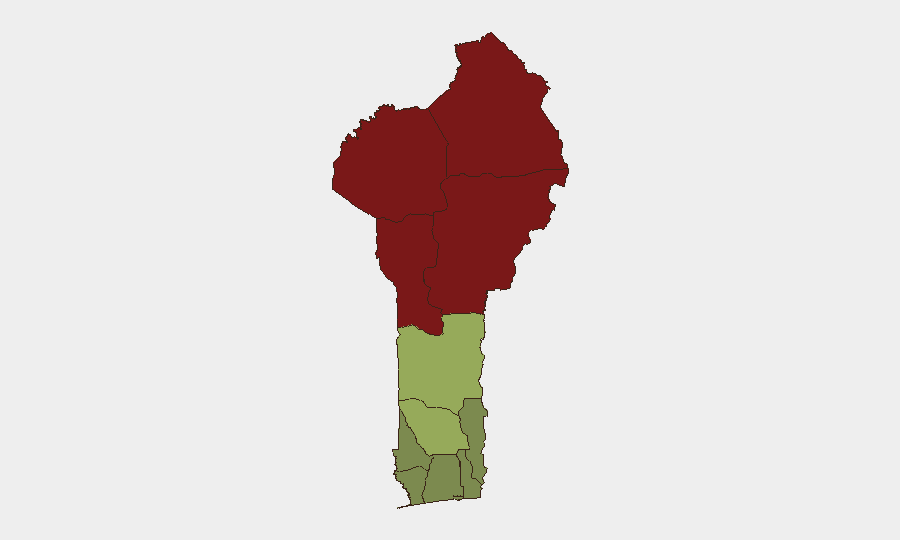
Situation Summary
Benin remains a composite threat rank of 50 globally (#37), with 8 tracked events in the monitoring window. No clearly documented, cross-confirmed security incidents have emerged in open sources or social media in the last 24–48 hours; the absence of reported new events does not indicate lowered risk, but rather reflects current reporting gaps. The security environment remains shaped by persistent northern border vulnerabilities and localized crime in urban centers, with threat concentration in the Sahel-facing departments of Alibori, Atakora, Donga, and Borgou.
Key Developments
- No discrete, time-stamped incidents in Benin (country) confirmed in open sources for 2026-06-20 through 2026-06-22. Web research and X/Twitter OSINT found references to "Benin City" (Edo State, Nigeria) and non-incident institutional content, but no verifiable new security events meeting location and date specificity criteria for the Republic of Benin.
- Monitored event signals include domestic political statements and disapproval statements (2026-06-21 to 2026-06-22). Exact operational context and locations remain under analysis; no escalation to violence or infrastructure impact has been confirmed in current reporting.
- Regional Sahel instability persists adjacent to northern Benin borders. Niger and Burkina Faso continue to report terrorism and military activity; spillover risk to Alibori and Atakora remains standing baseline threat.
- Urban crime (Cotonou, Porto-Novo) remains endemic. No surge or organized crime escalation reported in the last 48 hours, but seasonal and structural vulnerabilities persist.
Highest-Risk Areas
Alibori (92), Atakora (88), Donga (85), and Borgou (83) constitute Benin's critical risk belt, all located in the north and northwest where porous borders with Niger and Burkina Faso enable cross-border terrorism, arms trafficking, and militia activity. These four departments account for the majority of threat signal concentration and are the primary locus for kidnapping, insurgent recruitment, and militancy. Southern and coastal departments (Littoral, Ouémé, Atlantique) score substantially lower (22–28) but remain vulnerable to organized crime and petty violence; Zou and Collines (45, 42) represent a mid-tier transition zone. Organizations with field presence or supply chains north of the Zou line require enhanced vetting, movement protocols, and liaison with local security authorities.
How GeoBit Would Assist
A security team protecting personnel or assets in Benin should employ AOI Monitoring & Early Warning to establish persistent watch over northern departments, with automated alerting on civil unrest, militant activity, or border-crossing incidents. Intel Sweep and multi-language OSINT (including Telegram and local news feeds) provide real-time conflict and crime signal aggregation, filling gaps where mainstream Western media coverage is sparse. GIS & Spatial Analysis linked to Network & Actor Analysis enable mapping of trafficking routes, militant cell locations, and crime corridors to support convoy routing and facility siting decisions.
7-Day Outlook
No dramatic escalation is signaled in current reporting; however, the Sahel's volatility and Benin's border exposure mean that transnational militant activity or spillover violence can emerge with little warning. Continued monitoring of Niger and Burkina Faso military activity, cross-border displacement, and local supply-chain disruptions is prudent. The next 7 days will likely replicate baseline conditions absent fresh geopolitical shock or regional military action.
Highest-Risk Areas — Ranked
| # | State / Region | Risk |
|---|---|---|
| 1 | Alibori Department | 92 |
| 2 | Atakora Department | 88 |
| 3 | Donga Department | 85 |
| 4 | Borgou Department | 83 |
| 5 | Zou Department | 45 |
| 6 | Collines Department | 42 |
| 7 | Plateau Department | 38 |
| 8 | Kouffo Department | 35 |
| 9 | Mono Department | 32 |
| 10 | Atlantique Department | 28 |
| 11 | Littoral | 25 |
| 12 | Ouémé Department | 22 |
Sources
Previous Daily Briefs
A new Benin brief is written every day — each with its own risk map and downloadable CSV. Here's the last week; use the calendar to go further back.
📅 Browse every day by calendar →
Highlighted days have a brief. Tap a day for that day's map & analysis, or “csv” for that day's dataset ($5).