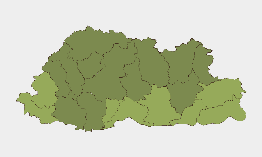
Situation Summary
Bhutan maintains a low overall security threat profile (composite score 14; unranked globally) with no confirmed security incidents, civil unrest, or cross-border instability reported in open sources during the last 24–48 hours. However, three tracked events—including territory occupation, threats to security personnel, and an arrest/detention—were logged between 17–18 June and warrant continued monitoring. Southern border districts (Samtse, Sarpang, Haa) show elevated composite risk scores, though underlying drivers remain opaque in English-language reporting and warrant investigation via multi-language and local-channel OSINT.
Key Developments
- No confirmed security incidents reported in English-language open sources for the 24–48 hours preceding 20 June 2026. All available news, government, and social-media channels show routine activity only.
- Three tracked events logged 17–18 June (outside the immediate 24–48h window but recent): territory occupation, threats directed at security personnel, and an arrest/detention incident—specific locations and nature remain under corroboration.
- Data sparsity noted: Bhutan's low levels of overt reporting in English-language channels and limited open-source coverage of local incidents in Dzongkha or regional media reduce real-time visibility; incidents may be under-reported or delayed in reaching international channels.
Highest-Risk Areas
Samtse, Sarpang, and Haa Districts in southern Bhutan collectively drive the sub-national risk ranking (scores 58, 55, and 52 respectively), likely reflecting proximity to the India–Bhutan border, historical cross-border tensions, and potential resource or territorial disputes. Pemagatshel and Samdrup Jongkhar Districts (scores 50 and 48) along the eastern border merit parallel attention. Northern and central districts (Lhuntse, Wangdue Phodrang, Gasa) register substantially lower scores, suggesting security risk clusters along Bhutan's international frontiers rather than internal instability. The absence of detailed causal reporting in open sources limits immediate assessment; GeoBit research should prioritize underlying drivers—smuggling networks, border demarcation disputes, cross-border movement, resource competition—to improve forecasting.
How GeoBit Would Assist
Intel Sweep and Multi-Language OSINT targeting Dzongkha-language media, local government announcements, and regional social platforms would reduce reporting latency and surface incidents before international dissemination. AOI Monitoring & Early Warning on Samtse, Sarpang, and Haa Districts with persistent watch and alerting would flag emerging threats in real time. Network & Actor Analysis combined with Border & Disputed-Territory Search would map smuggling routes, cross-border militant movements, and territorial claims that contextualize the three recent events and inform duty-of-care planning for personnel in high-risk southern districts.
7-Day Outlook
No acute escalation is expected over the next seven days based on current reporting. However, the three logged events (17–18 June) suggest underlying tensions that may not be visible in English-language channels; continued monitoring of border-district activity is warranted. Corporate teams with assets or personnel in Samtse, Sarpang, or Haa should maintain heightened situational awareness and ensure communication protocols with local security authorities remain active.
Highest-Risk Areas — Ranked
| # | State / Region | Risk |
|---|---|---|
| 1 | Samtse District | 58 |
| 2 | Sarpang District | 55 |
| 3 | Haa District | 52 |
| 4 | Pemagatshel District | 50 |
| 5 | Samdrup Jongkhar District | 48 |
| 6 | Tsirang District | 45 |
| 7 | Zhemgang District | 42 |
| 8 | Trashigang District | 40 |
| 9 | Mongar District | 38 |
| 10 | Gasa District | 35 |
| 11 | Lhuntse District | 32 |
| 12 | Wangdue Phodrang District | 30 |
Sources
Previous Daily Briefs
A new Bhutan brief is written every day — each with its own risk map and downloadable CSV. Here's the last week; use the calendar to go further back.
📅 Browse every day by calendar →
Highlighted days have a brief. Tap a day for that day's map & analysis, or “csv” for that day's dataset ($5).