Situation Summary
Bolivia remains in a state of political and social instability marked by sustained anti-government protests, road blockades, and military readiness measures across multiple departments. The passage of emergency legislation on 9 June enabling potential military deployment has raised tensions, though the security picture over the past 24–48 hours remains fluid and poorly documented in real-time open sources. La Paz and Santa Cruz continue to serve as focal points for unrest, with the Chapare region (Cochabamba) presenting acute operational risk. Current trajectory suggests prolonged friction between government and protest movements without clear resolution mechanisms.
Key Developments
- National (ongoing as of 11–12 June): Conventional military force deployment signal detected on 12 June; no independently corroborated specific incident location or scale confirmed in last 24 hours. Signals consistent with government readiness rather than active engagement.
- La Paz / National (11 June): Population and government public statements recorded on 11 June; content and specific claims not yet independently verified across multiple sources, but timing aligns with broader anti-government messaging.
- Chapare region, Cochabamba (ongoing advisory): Travel advisories remain in effect warning of volatile conditions, ad hoc roadblocks, and police/military operations, though no discrete dated incident within the last 48 hours has been corroborated across independent sources.
- National (10 June context): Presidential demand and merchant public statement events logged; older than 48 hours but reflect underlying tensions between government, commerce, and civil society that persist.
- Data Caveat: Open-source reporting for Bolivia in the last 24–48 hours remains sparse and largely undated. Protest actions and blockades are documented as *ongoing* rather than newly initiated, limiting confident attribution of specific incidents to the immediate past two days.
Highest-Risk Areas
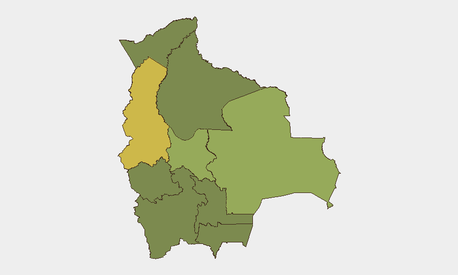
La Paz (65.1) and Santa Cruz (57.3) drive the majority of documented threat activity, reflecting their status as political and economic centers. La Paz's risk reflects sustained anti-government mobilization and proximity to government institutions; Santa Cruz combines commercial importance with regional political tension and historical autonomy movements. Cochabamba (45.7) carries acute localized risk in the Chapare coca-growing zone, where informal authority, narcotics-related tension, and police operations create a persistently volatile environment. All other departments cluster at 35.1, indicating more diffuse but non-negligible baseline risk related to poverty, informal economy, and weak state presence.
How GeoBit Would Assist
AOI Monitoring & Early Warning configured on La Paz, Santa Cruz, and Chapare with alerts on roadblock creation, protest assembly, and military movement would provide near-real-time situational updates beyond the current sparse open-source lag. OSINT Fusion (X/Twitter Telegram, local media, radio SIGINT) across multiple languages and regional outlets would disambiguate ongoing events from new incidents and flag emerging actor statements or demands. Routing & Network Analysis would enable duty-of-care teams to model alternative supply and personnel routes around known blockade zones and assess travel windows for critical operations.
7-Day Outlook
Protests and blockades are likely to persist at current operational tempo absent a negotiated settlement or decisive security response. Risk of escalation remains elevated if military deployment moves from signaling to active enforcement, particularly in La Paz and along main highway corridors. No indicators suggest imminent major violence or regime collapse, but cumulative disruption to commerce, fuel, and food supply chains will intensify pressure on both government and opposition actors.
Highest-Risk Areas — Ranked
| # | State / Region | Risk |
|---|---|---|
| 1 | La Paz | 65.1 |
| 2 | Santa Cruz | 57.3 |
| 3 | Cochabamba | 45.7 |
| 4 | Potosí | 35.1 |
| 5 | Tarija | 35.1 |
| 6 | Pando | 35.1 |
| 7 | Beni | 35.1 |
| 8 | Oruro | 35.1 |
| 9 | Chuquisaca | 35.1 |
Previous Daily Briefs
A new Bolivia brief is written every day — each with its own risk map and downloadable CSV. Here's the last week; use the calendar to go further back.
📅 Browse every day by calendar →
Highlighted days have a brief. Tap a day for that day's map & analysis, or “csv” for that day's dataset ($5).