Situation Summary
Brunei remains a low-threat environment globally (composite threat score 5; #162 globally) with no credible reports of violent incidents, unrest, or security emergencies in the last 24–48 hours. The primary near-term operational concerns are environmental—prolonged extreme heat (38.2°C peak), below-normal rainfall, and transboundary haze from Indonesian peatland fires—rather than physical security threats. Internal governance scrutiny of zakat administration indicates heightened official oversight but poses no direct threat to corporate operations or personnel safety.
Key Developments
- Bandar Seri Begawan, 24 Aug 2026 – Sultan Hassanal Bolkiah ordered immediate reforms to zakat (alms) administration, citing financial governance shortcomings, delayed assistance delivery, and alleged misconduct. This reflects heightened administrative integrity scrutiny but does not constitute unrest or security incident.
- National / multiple districts, 24 Aug 2026 (ongoing) – Brunei Meteorological Department warns of persistent extreme heat (14 consecutive days; 8–21 Aug peak) and transboundary haze from Indonesian fires expected through end of August. Conditions elevate fire risk and strain on water/power infrastructure; no active blackouts or evacuations reported.
- Brunei / Malaysia border region, 24 Aug 2026 – Malaysian and Bruneian officials meeting in Bandar Seri Begawan agreed to deploy ASEAN mechanisms to address transboundary haze and coordinate forest-fire response in Kalimantan. Indonesian aerial firefighting and troop deployments ongoing; risk to air quality and visibility but no border incidents reported.
- Brunei–Malaysia bilateral, 22 Aug 2026 – The 27th Malaysia–Brunei Annual Leaders' Consultation concluded with agreements to strengthen disaster-management cooperation and pilot single-checkpoint border systems. Policy-level development; no operational border disruption reported.
- No acute crime, conflict, or infrastructure incidents reported in last 48 hours – Web research confirms absence of credible reports of riots, terrorist attacks, armed clashes, mass-casualty crime, or major power/transport failures.
Highest-Risk Areas
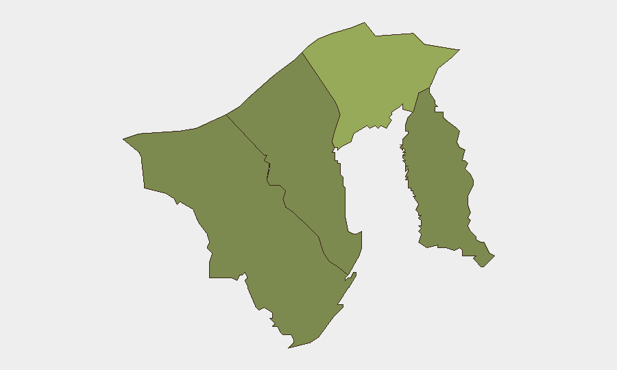
Brunei-Muara District carries significantly elevated composite risk (45) and warrants the most focused monitoring, primarily due to concentration of capital infrastructure, government facilities, and population density in Bandar Seri Begawan. Tutong District (risk 20) ranks second, followed by Belait and Temburong. The gap between Brunei-Muara and all others reflects administrative and economic centralization rather than active conflict or instability; risk drivers are predominantly environmental (heat, haze, air quality) and governance-related rather than violent.
How GeoBit Would Assist
Security teams should employ AOI Monitoring & Early Warning to track air-quality indices, rainfall anomalies, and fire-risk progression across Brunei-Muara and neighboring Indonesian provinces through satellite and environmental feeds. Intel Sweep and multi-language OSINT (X, Telegram, local news) will provide rapid detection of any unscheduled civil unrest, infrastructure failures, or cross-border incidents. Routing & Network Analysis can pre-plan alternative travel paths and supply-chain contingencies should transboundary haze or heat-related disruptions affect Bandar Seri Begawan or key districts.
7-Day Outlook
Heat and haze conditions are forecast to persist through end of August; air quality and infrastructure strain remain the primary operational risk factors. No indicators of political instability, civil unrest, or acute security deterioration are evident. Corporate operations should maintain standard heat/air-quality mitigation measures and monitor Indonesian fire-suppression progress via regional ASEAN updates; no escalation of threat posture is currently warranted.
Highest-Risk Areas — Ranked
| # | State / Region | Risk |
|---|---|---|
| 1 | Brunei-Muara District | 45 |
| 2 | Tutong District | 20 |
| 3 | Belait District | 15 |
| 4 | Temburong District | 10 |
Sources
Previous Daily Briefs
A new Brunei brief is written every day — each with its own risk map and downloadable CSV. Here's the last week; use the calendar to go further back.
- August 22, 2026
- August 20, 2026
- August 18, 2026
- August 16, 2026
- August 14, 2026
- August 12, 2026
- August 10, 2026
📅 Browse every day by calendar →
Highlighted days have a brief. Tap a day for that day's map & analysis, or “csv” for that day's dataset ($5).
Atlas — our AI intelligence desk — emails them this snapshot personally. Nothing else, no list.