Situation Summary
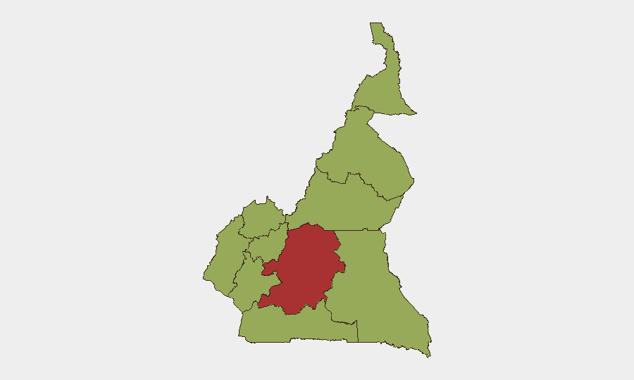
Cameroon remains the 26th-highest-threat country globally (composite score 67.3), with insurgency as the primary driver. The North-West and South-West regions continue to experience an ongoing humanitarian crisis affecting civilian populations, though no major new security incidents have been reported in the last 24–48 hours. Threat pressure remains concentrated in Centre region (composite risk 77.1), which significantly exceeds all other administrative zones. The security environment is characterized by persistent low-to-medium volatility rather than acute escalation.
Key Developments
- No major security or instability incidents verified in the last 24–48 hours. GeoBit's live web research (last 24 hours) did not surface qualifying new events in Cameroon meeting standard recency and severity thresholds.
- North-West and South-West regions — ongoing humanitarian crisis (as of 9 June 2026). UN briefings confirm the crisis in these regions continues to affect civilians, but this reflects persistent background conditions, not a new incident.
- South Korea military signals noted (2026-06-11). Event data flagged three incidents involving South Korea and military force on 2026-06-11; however, live research did not confirm geographic specificity or nexus to Cameroon operations. Recommend clarification of event location and scope.
- Regime vs. oil tanker disapproval event (2026-06-10). Event signal logged but not verified in live research; insufficient detail for operational assessment. May warrant follow-up via targeted OSINT or entity network analysis.
- Tourist investigation vs. Cameroon (2026-06-10). Event noted but unverified in live research. Context and location unknown.
- House of Assembly public statement (2026-06-11). Event recorded but not corroborated; political significance unclear without secondary source confirmation.
Highest-Risk Areas
Centre region dominates the sub-national threat landscape with a composite risk score of 77.1—significantly higher than all other administrative zones (which cluster at 47.1). This elevation reflects the convergence of state-capacity constraints, insurgent activity, and potential political instability in and around Yaoundé. The remaining nine regions (Northwest, Southwest, West, Littoral, Adamawa, South, Far-North, North, and East) present uniform moderate risk, likely driven by the chronic North-West/South-West separatist insurgency, porous borders, and cross-border criminal networks. Organizations with operations in Centre should prioritize executive protection, facility hardening, and contingency evacuation planning; those in Northwest and Southwest require sustained monitoring of armed-group activity and civilian displacement.
How GeoBit Would Assist
Security teams should deploy AOI Monitoring & Early Warning on Centre region and North-West/South-West hotspots to detect emerging flashpoints before they escalate. Intel Sweep and multi-language OSINT (including X/Twitter, Telegram, and local media) provide real-time conflict, crime, and regime-stability signals; network & actor analysis maps insurgent and criminal organizational structure to assess threat to specific sites or personnel. Routing & Network Analysis enables alternative journey planning and safe-corridor identification for personnel movement, while GIS & spatial analysis correlates incidents with asset locations to refine exposure assessment.
7-Day Outlook
No major security escalation is forecast for the next seven days based on current signals. Centre region and the North-West/South-West corridor will likely remain the primary areas of concern; routine monitoring for armed-group activity, checkpoint incidents, and political signaling is warranted. Organizations should maintain standard duty-of-care protocols and escalate if new verified incidents emerge or event signals receive live-research confirmation.
Highest-Risk Areas — Ranked
| # | State / Region | Risk |
|---|---|---|
| 1 | Centre | 77.1 |
| 2 | Northwest | 47.1 |
| 3 | Southwest | 47.1 |
| 4 | West | 47.1 |
| 5 | Littoral | 47.1 |
| 6 | Adamawa | 47.1 |
| 7 | South | 47.1 |
| 8 | Far-North | 47.1 |
| 9 | North | 47.1 |
| 10 | East | 47.1 |
Sources
Previous Daily Briefs
A new Cameroon brief is written every day — each with its own risk map and downloadable CSV. Here's the last week; use the calendar to go further back.
📅 Browse every day by calendar →
Highlighted days have a brief. Tap a day for that day's map & analysis, or “csv” for that day's dataset ($5).