Situation Summary
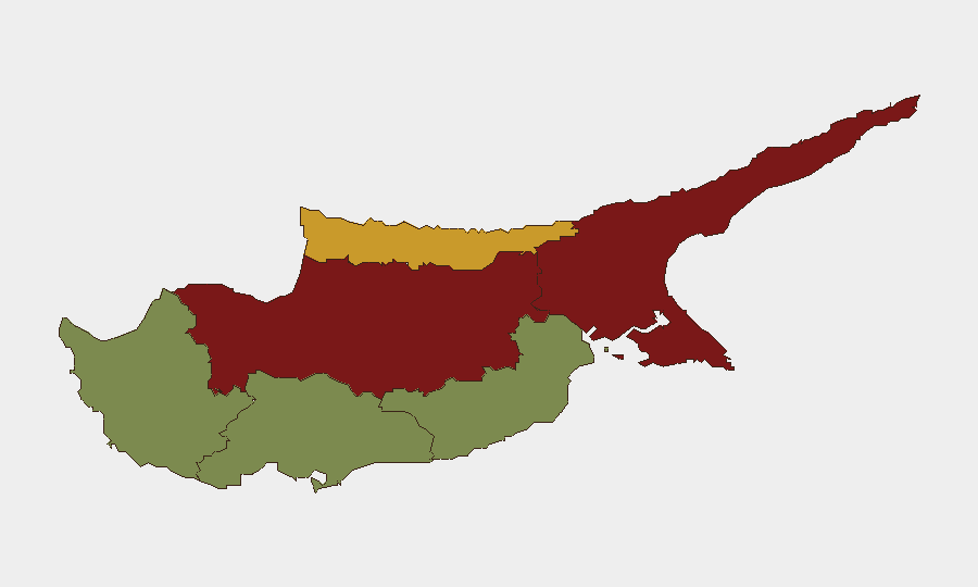
Cyprus remains a stable, low-threat environment globally (rank #111, composite score 9) with no credible reports of active armed conflict, civil unrest, or major security incidents in the last 24–48 hours. The country's security profile is shaped primarily by underlying geopolitical tensions—EU–Turkey diplomatic friction and the unresolved Cyprus division—rather than acute, imminent threats to residents or business operations. Risk is heavily concentrated in the northern divided territories (Nicosia, Famagusta, Kyrenia), while southern urban and tourist centers (Limassol, Paphos, Larnaca) remain low-risk.
Key Developments
- Limassol – June 25, 2026: Adsterra, a Limassol-based ad-tech firm, announced enhanced anti-fraud and anti-malware controls, signaling ongoing cyber-crime and online fraud risk affecting businesses headquartered in Cyprus. No direct incident reported; announcement reflects defensive posture.
- EU–Turkey diplomatic signals – June 26, 2026: EU public statements and disapproval signals toward Turkey recorded in event feeds; no direct military, economic, or territorial escalation in or immediately affecting Cyprus confirmed in open sources.
- Cyprus–EU administrative and policy messaging – June 26, 2026: Public statements and administrative sanctions involving Cyprus and EU entities noted; routine regulatory or trade-related activity, not security-incident-level.
- Banking sector notification – June 24, 2026: Bank-related rejection signal recorded; insufficient detail in open sources to confirm scope or impact; monitor for possible compliance or regulatory developments affecting financial services.
- No confirmed crime, infrastructure, or travel disruptions – last 48 hours: Open web and social media monitoring reveal no credible reports of criminal incidents, accidents, strikes, infrastructure failures, or official travel warnings issued or updated within Cyprus.
Highest-Risk Areas
Nicosia (risk 92) and Famagusta (risk 88)—both in the Turkish-Cypriot north and the demilitarized buffer zone—drive the country's composite risk profile, reflecting the unresolved political division, proximity to Turkey, and legacy tensions. Kyrenia (risk 72) follows as a secondary high-risk node, also in the north. By contrast, southern districts (Larnaca 28, Limassol 22, Paphos 18) reflect the lower operational risk of the Republic of Cyprus–controlled territories, where business, tourism, and government functions operate without acute security disruption. Corporate and duty-of-care exposure scales sharply with proximity to the Green Line and Turkish border.
How GeoBit Would Assist
Intel Sweep and OSINT fusion would monitor cross-border tensions, EU–Turkey diplomatic signals, and Turkish military posture in real time, flagging escalation signals before they affect Cyprus operations. AOI monitoring with persistent alerting on Nicosia, the buffer zone, and maritime approaches enables early warning of political incidents, protests, or security-force movements that could affect supply chains or personnel movement. Conflict and regime-stability tracking, combined with network and actor analysis of Turkish and Cypriot political elites, provides forward indicators of negotiation breakdowns or policy shifts affecting residual risk in the north.
7-Day Outlook
No acute escalation is forecast; geopolitical friction between the EU and Turkey will likely remain at current levels of diplomatic posturing and regulatory messaging without translating into kinetic or economic disruption to Cyprus. Southern Cyprus remains suitable for normal business operations with standard due diligence; northern access and asset exposure warrant continued monitoring via intelligence feeds and persistent area-of-interest watch.
Highest-Risk Areas — Ranked
| # | State / Region | Risk |
|---|---|---|
| 1 | Nicosia | 92 |
| 2 | Famagusta | 88 |
| 3 | Kyrenia | 72 |
| 4 | Larnaca | 28 |
| 5 | Limassol | 22 |
| 6 | Paphos | 18 |
Sources
Previous Daily Briefs
A new Cyprus brief is written every day — each with its own risk map and downloadable CSV. Here's the last week; use the calendar to go further back.
📅 Browse every day by calendar →
Highlighted days have a brief. Tap a day for that day's map & analysis, or “csv” for that day's dataset ($5).