Situation Summary
Dominica remains at a composite threat score of 50 globally, reflecting moderate baseline risk with no substantiated security incidents documented in the last 24–48 hours. Web research confirms no credible time-stamped events (conflict, unrest, crime, or infrastructure disruption) within the reporting window. Unverified social-media signals—including a rumor of a curfew and reports of earth movements in Gallion and a suspected drowning in Calibishie—lack independent corroboration and should not be treated as confirmed incidents at this time. The threat picture remains largely routine governance and infrastructure activity.
Key Developments
- No confirmed incidents in the last 24–48 hours: Web research across local media, official sources, and social channels identified no substantiated security, conflict, civil-unrest, crime, or infrastructure events in Dominica during the reporting window.
- Unverified curfew/state-of-emergency rumor: A social-media signal circulated regarding possible restrictions, but lacks timing specificity and multi-source confirmation; not actionable without further corroboration.
- Reported earth movements (Gallion community): A Facebook post from Dominica Broadcasting Station mentions tremors and rumbling sounds; insufficient independent verification to confirm date, severity, or operational impact.
- Suspected drowning (Calibishie): The same source reports recovery of a body from the sea; lacks corroborated timeline and detail to assess as a confirmed last-48-hour event.
- Routine governance and infrastructure updates: Remaining signals reflect normal administrative activity rather than acute security triggers.
Highest-Risk Areas
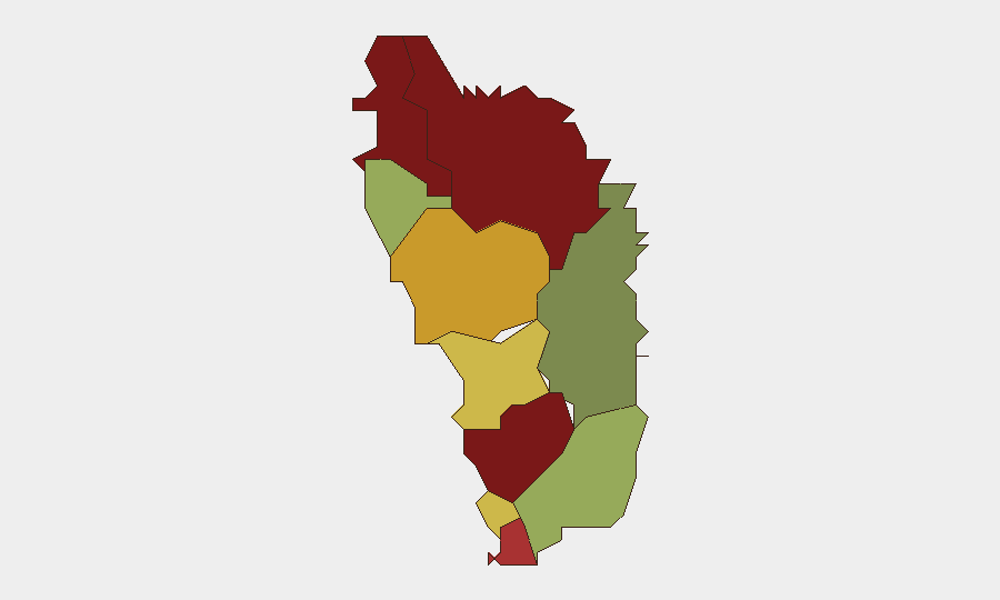
Saint Andrew, Saint John, and Saint George parishes drive the sub-national risk profile (scores 92, 88, and 81 respectively), followed by Saint Mark and Saint Joseph (78 and 72). The concentration of risk in the northern and central parishes suggests localized governance, service-delivery, or socioeconomic pressures; Saint David Parish shows substantially lower risk (35), indicating geographic variance. The reason for this clustering—whether tied to population density, economic activity, past incidents, or infrastructure gaps—requires deeper parish-level analysis to inform asset and personnel placement.
How GeoBit Would Assist
Intel Sweep and OSINT fusion across local media, official government channels, and social platforms would establish a baseline of routine activity and flag genuine departures in real time. AOI Monitoring & Early Warning with persistent watch on high-risk parishes (particularly Saint Andrew and Saint John) would trigger alerts on credible unrest, infrastructure failure, or security incidents before they escalate, enabling rapid duty-of-care response. Multi-language search and entity extraction on Dominica-focused social channels would filter signal from noise, surfacing verified incidents and excluding unsubstantiated rumors—critical for decision-making when web sources are sparse or fragmented.
7-Day Outlook
No acute escalation is forecast over the next seven days based on current signal patterns. Continued monitoring of northern parishes is warranted, given their elevated composite scores; any confirmation of the unverified rumors (curfew, unrest, infrastructure damage) should trigger immediate reassessment. Organizations with people or assets in Saint Andrew, Saint John, or Saint George should maintain routine situational awareness and ensure contingency plans are current.
Highest-Risk Areas — Ranked
| # | State / Region | Risk |
|---|---|---|
| 1 | Saint Andrew Parish | 92 |
| 2 | Saint John Parish | 88 |
| 3 | Saint George Parish | 81 |
| 4 | Saint Mark Parish | 78 |
| 5 | Saint Joseph Parish | 72 |
| 6 | Saint Paul Parish | 68 |
| 7 | Saint Luke Parish | 62 |
| 8 | Saint Peter Parish | 55 |
| 9 | Saint Patrick Parish | 48 |
| 10 | Saint David Parish | 35 |
Sources
Previous Daily Briefs
A new Dominica brief is written every day — each with its own risk map and downloadable CSV. Here's the last week; use the calendar to go further back.
📅 Browse every day by calendar →
Highlighted days have a brief. Tap a day for that day's map & analysis, or “csv” for that day's dataset ($5).
Atlas — our AI intelligence desk — emails them this snapshot personally. Nothing else, no list.