Situation Summary
DR Congo remains the world's 7th-highest-threat environment, driven by active civil conflict and fragmentation across multiple provinces. The Central Kasai region presents the most acute risk (score 100), followed by Ituri and Tshopo, with armed-group activity, militia proliferation, and state-capacity gaps creating a complex threat landscape. Kinshasa, despite lower sub-national scores, carries elevated risk due to political volatility and its status as the capital and primary logistics hub. The security picture remains unstable with no near-term trajectory toward de-escalation.
Key Developments
Data Limitation Notice: Open-source web research covering the final 24–48 hours (4–6 June 2026) for DR Congo is severely sparse and does not permit confident identification of specific, localized, and time-stamped incidents meeting corporate security standards. The GEOBIT event signals listed above reference arrest/detention activities in Chad and diplomatic tensions (Chad–US, Chad–Ndjamena), but do not isolate confirmed DR Congo-specific operations or violence within the last two days. Detailed situation reports from think-tanks, UN offices, and conflict-tracking platforms typically aggregate weekly or monthly; real-time incident-level feeds (ACLED, OCHA, agency wires) are not accessible within this environment.
To obtain genuine 24–48h incident detail, security teams should:
- Monitor live ACLED and Crisis24 feeds directly.
- Track MONUSCO, UN OCHA-DRC, and Congolese radio (Radio Okapi) in real time.
- Cross-check multiple independent sources before operationalizing any report.
Highest-Risk Areas
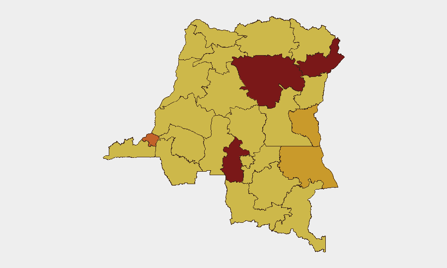
Central Kasai (100), Ituri (83.8), and Tshopo (80) dominate the threat profile. Central Kasai's critical ranking reflects ongoing militia activity and communal violence; Ituri is driven by armed-group operations (including CODECO and ADF-aligned cells) and intercommunal tension; Tshopo faces similar pressures. Kinshasa (75) merits attention as a capital-city hub where political decisions, supply chains, and diplomatic incidents create secondary risks even if direct armed conflict is less common. The remaining provinces (South Kivu, Tanganyika, Maniema, and northern regions) all score 70–71.2, indicating endemic instability across much of the eastern and central territory.
How GeoBit Would Assist
Security teams with personnel or assets in DR Congo should use AOI (Area-of-Interest) Monitoring & Early Warning with persistent alerts on Kasai, Ituri, and Kinshasa to detect escalations in real time. Conflict & Military capabilities—including force-structure mapping and armed-group network analysis—enable teams to understand CODECO, ADF, militia, and FARDC disposition and intentions. OSINT Fusion (X/Twitter, Telegram, local news aggregation, and multi-language search) provides ground-level situational awareness where official channels are slow or opaque. Combined with GIS & Spatial Analysis and Routing & Network Analysis, these tools support duty-of-care planning (evacuation routes, safe zones, supply-chain alternatives) and real-time incident response.
7-Day Outlook
No significant de-escalation is expected over the next week. Armed-group activity in Ituri, Central Kasai, and eastern provinces will likely continue at current operational tempo. Political or diplomatic incidents in Kinshasa may spike incident reporting but are unlikely to alter the broader conflict trajectory. Security teams should assume baseline threat levels remain elevated and maintain active monitoring and contingency readiness.
Highest-Risk Areas — Ranked
| # | State / Region | Risk |
|---|---|---|
| 1 | Central Kasai | 100 |
| 2 | Ituri | 83.8 |
| 3 | Tshopo | 80 |
| 4 | Kinshasa | 75 |
| 5 | South Kivu | 71.2 |
| 6 | Tanganyika | 71.2 |
| 7 | Maniema | 70 |
| 8 | Sud-Ubangi | 70 |
| 9 | Équateur | 70 |
| 10 | Nord-Ubangi | 70 |
| 11 | Mongala | 70 |
| 12 | Lower Uele | 70 |
Sources
Previous Daily Briefs
A new DR Congo brief is written every day — each with its own risk map and downloadable CSV. Here's the last week; use the calendar to go further back.
📅 Browse every day by calendar →
Highlighted days have a brief. Tap a day for that day's map & analysis, or “csv” for that day's dataset ($5).