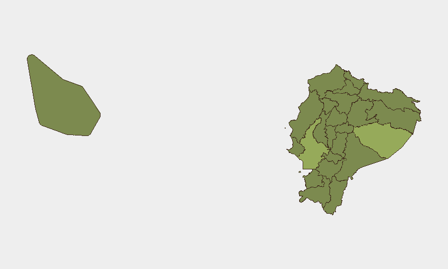
Situation Summary
Ecuador remains at moderate overall threat (rank #38 globally, composite score 35.1), but faces acute subnational volatility concentrated in the eastern Amazon and southwestern coastal regions. Recent signal activity (last 48 hours) indicates indigenous-community disputes, alleged small-arms combat, and civil-sector occupations, alongside investigative and disapproval actions targeting state institutions. The security posture is fragile and event-driven; trajectory remains downward without de-escalation of institutional tensions and territorial disputes.
Key Developments
- 2026-06-11 · Indigenous vs. Community Reject – Two distinct signals flagged; specific location and trigger unknown from available metadata. Signals suggest rejection or breakdown in inter-community dialogue, likely in Amazon or highland zones where indigenous land-use and settlement disputes are endemic.
- 2026-06-09 · Small Arms Combat (Ecuador) – Armed engagement reported; no confirmed location or casualty count in available brief. Concurrent investigation signal suggests state/security response mobilized.
- 2026-06-09 · Presidential Demand – Executive branch facing formal demand; likely related to institutional accountability or security-force conduct. Mirrors concurrent disapproval signals (2026-06-10) targeting President and National Police.
- 2026-06-10 · Territory Occupation (Fire Brigade & Companies) – Civilian entities (fire services, private companies) occupying territory; signals suggest labor dispute, service-delivery grievance, or protest action. Public statement by lawyer (2026-06-10) indicates legal contestation underway.
- 2026-06-10 · Police & Presidential Disapproval – Public disapproval registered against National Police and Presidential conduct on same date. Consistent with institutional legitimacy erosion and public accountability pressure in security/governance.
Highest-Risk Areas
Pastaza Province (54.6) and Guayas Province (46.4) drive national threat concentration. Pastaza—a remote, sparsely populated Amazon region—ranks highest; risk drivers likely include trafficking corridors, illicit-economy control, and indigenous-settler friction over resource extraction and land tenure. Guayas (Guayaquil metro) is Ecuador's economic and population hub; its score (46.4) reflects urban crime, gang turf disputes, and smuggling-network activity tied to Pacific ports. Esmeraldas Province (33.6) and Santa Elena Province (33.1) follow, both coastal zones vulnerable to narcotics trafficking and port-security compromise. Pichincha Province (29.7), containing the capital Quito, registers moderate-to-elevated risk from protest cycles, institutional fragility, and criminal-gang presence in peripheral municipalities.
How GeoBit Would Assist
Intel Sweep and OSINT Fusion enable continuous monitoring of event signals, social-media sentiment, and official announcements (Policía Nacional, ECU 911, ministerial channels) to detect emerging civil or armed incidents before escalation. Early Warning & Prediction and AOI Monitoring capabilities allow security teams to set persistent watches on Pastaza, Guayas, and Esmeraldas—flagging resource conflicts, territorial occupations, or armed activity—with automated alerts keyed to corporate asset locations or personnel transit routes. Routing & Network Analysis supports real-time alternative-route planning for personnel or supply chains, rerouting around occupied zones or active incidents identified via live event feeds and spatial analysis.
7-Day Outlook
No major policy shifts or security-force redeployment signals evident in the last 48 hours; near-term risk trajectory likely remains flat to slightly elevated as institutional tensions persist and subnational disputes continue. Watch for escalation in Pastaza (resource/land disputes) and Guayas (urban-crime cycles); de-escalation of police-accountability pressure and resolution of company/fire-brigade occupations would signal stabilization. Monitor presidential and police statements for reforms or tactical shifts that could reduce disapproval and restore institutional legitimacy.
Highest-Risk Areas — Ranked
| # | State / Region | Risk |
|---|---|---|
| 1 | Pastaza Province | 54.6 |
| 2 | Guayas Province | 46.4 |
| 3 | Esmeraldas Province | 33.6 |
| 4 | Santa Elena Province | 33.1 |
| 5 | Imbabura Province | 30.6 |
| 6 | Pichincha Province | 29.7 |
| 7 | Carchi Province | 26.3 |
| 8 | Manabí Province | 25 |
| 9 | Napo Province | 25 |
| 10 | Azuay Province | 25 |
| 11 | Sucumbíos Province | 24.6 |
| 12 | Orellana Province | 24.6 |
Previous Daily Briefs
A new Ecuador brief is written every day — each with its own risk map and downloadable CSV. Here's the last week; use the calendar to go further back.
📅 Browse every day by calendar →
Highlighted days have a brief. Tap a day for that day's map & analysis, or “csv” for that day's dataset ($5).