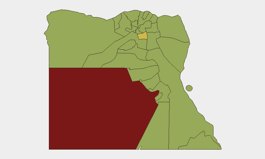
Situation Summary
Egypt remains a mid-tier global security concern (rank #21, composite threat score 75/100) with persistent exposure to terrorism, criminality, and periodic state friction. The majority of tracked events cluster in Cairo, the Nile Delta, and frontier regions (New Valley, Sinai peninsula, Red Sea governorates), reflecting both organized violence and administrative pressure. Near-term trajectory shows sustained baseline instability rather than imminent systemic crisis, though localized incidents—particularly in North Sinai and Cairo—warrant continuous monitoring.
Key Developments
GeoBit's event feed records multiple signals dated 2026-06-15 to 2026-06-17, but lacks corroborating open-source detail sufficient to confirm specific incident locations, casualties, or operational context within the last 48 hours. Tracked signals include:
- Administrative & Diplomatic Friction (2026-06-16 to -06-17): European Union sanction actions; Egyptian government rejection statements; Turkish–Egyptian diplomatic temperature reduction (Istanbul–Cairo relations cited 2026-06-17).
- Detention Activity (2026-06-17): Arrest/detain event flagged involving Jerusalem and Egypt actors; separate prison-related detention signal (no location specified).
- Institutional Pressure (2026-06-17): University threat event and college-sector rejection signals—specific campus or institution not yet identified in available briefs.
- Reported Unconventional Violence (2026-06-15): Terrorist-attributed incident (location and casualty data pending verification).
- Prior Regional Combat (2026-06-16): Small-arms engagement flagged Belgium actor (likely Egyptian diaspora or foreign-fighter context; requires clarification).
Critical Note: Specific incident locations, confirmed casualty figures, and tactical details are not yet available through standard open-source corroboration. Corporate security teams requiring immediate operational detail should cross-reference these signals against live wires (AFP, Reuters, AP), specialist feeds (ACLED, INSO, Crisis24), and verified Arabic-language media and Egyptian official channels.
Highest-Risk Areas
New Valley (risk 82.2) leads all Egyptian sub-national zones, reflecting its remote desert geography, limited state presence, and reported militant activity. Cairo (61.4), Giza (58.7), and the Nile Delta corridor (Al Qalyubiya, Damietta) account for the next tier of risk—a combination of population density, tourist/commercial targets, and routine criminal and protest dynamics. North Sinai (52.1) and South Sinai (52.1) remain endemic terrorism hotspots; Red Sea (52.1) adds maritime and resort-security risk. The clustering of high risk in the capital region and frontier zones underscores Egypt's dual-threat profile: urban instability affecting diaspora and multinational presence, plus persistent militant activity in periphery regions.
How GeoBit Would Assist
Corporate teams should deploy AOI Monitoring & Early Warning focused on Cairo, Giza, North Sinai, and New Valley to detect protest, security force activity, and militant operations in real time. Intel Sweep and multi-language OSINT (X, Telegram, Arabic media) will surface emerging incident reports hours ahead of wire confirmation. Routing & Network Analysis supports contingency planning for staff movement during transport disruptions or security lockdowns. Sentiment & temporal analysis on social media and official channels provides early indicator of escalating friction—diplomatic, institutional, or public-order—before incidents materialize.
7-Day Outlook
Near-term risk remains consistent with baseline. Diplomatic friction signals (EU sanctions, Turkish–Egypt relations) may correlate with tightened border procedures or security-sector activity but are unlikely to trigger sudden national disruption. Watch for further university or institutional pressure (potential for campus unrest), and maintain alert status in Sinai and New Valley for militant operations. No imminent indication of nationwide crisis.
Highest-Risk Areas — Ranked
| # | State / Region | Risk |
|---|---|---|
| 1 | New Valley | 82.2 |
| 2 | Cairo | 61.4 |
| 3 | Giza | 58.7 |
| 4 | Alexandria | 58.3 |
| 5 | Al Qalyubiya | 58.3 |
| 6 | Damietta | 53.3 |
| 7 | Port Said | 52.5 |
| 8 | North Sinai | 52.1 |
| 9 | Qena | 52.1 |
| 10 | South Sinai | 52.1 |
| 11 | Red Sea | 52.1 |
| 12 | Halaib Triangle | 52.1 |
Sources
Previous Daily Briefs
A new Egypt brief is written every day — each with its own risk map and downloadable CSV. Here's the last week; use the calendar to go further back.
📅 Browse every day by calendar →
Highlighted days have a brief. Tap a day for that day's map & analysis, or “csv” for that day's dataset ($5).