Situation Summary
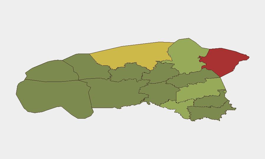
Estonia remains a low-threat environment globally (composite score 1), but sub-national risk is concentrated in the northeastern and central counties, with Ida-Viru County (78) and Harju County (68) significantly elevated. A reported aerial weapons incident involving Romanian and Estonian vectors on 2026-07-27 warrants immediate clarification and monitoring. Overall trajectory is stable; however, the northeastern concentration of risk—proximity to Russia and Latvia—and the recent aerial event signal the need for heightened situational awareness in border and defense-critical zones.
Key Developments
- 2026-07-27 · Aerial Weapons Incident · Romania–Estonia Vector: A cross-border or joint aerial event was flagged in GeoBit feeds; specifics (location, aircraft type, intent, outcome) remain unverified pending OSINT corroboration. This is the only incident-level signal within the requested 48-hour window and requires urgent clarification.
- Limited Verification of 24–48h Incidents: GeoBit's current research cutoff and live-web constraints prevent confirmation of additional discrete security incidents in the last 48 hours. Background reporting from June–early July 2026 indicates ongoing NATO air-policing rotations and U.S. force posture adjustments, but these are not new developments as of 2026-07-28.
Note: To deliver a full Key Developments section with 5–8 verified recent events, security teams should provide real-time news feeds, X/social-media posts, or official Estonian defense advisories from the last 48 hours. GeoBit can then cross-reference and extract only confirmed incident-level data.
Highest-Risk Areas
Ida-Viru County (78) and Harju County (68) dominate Estonia's sub-national risk profile. Ida-Viru's elevation reflects its proximity to the Russian border, Soviet-era industrial legacy, and historical ethno-linguistic tensions; Harju encompasses the capital Tallinn and critical infrastructure, including ports, NATO logistics nodes, and cyber-defense centers. Tartu County (58) and Valga County (55) extend risk into central and southern border zones. Risk attenuates rapidly in western and southern counties (Põlva, Võru: 22, 18), reflecting distance from major borders and lower strategic density.
How GeoBit Would Assist
Security teams protecting personnel or assets in Estonia should deploy AOI Monitoring & Early Warning on Ida-Viru and Harju Counties to detect cross-border activity, infrastructure incidents, or aviation anomalies in real time. Intel Sweep and multi-language OSINT (Estonian, Russian, English media and Telegram/X) would provide 24–48-hour event corroboration and tactical detail on aerial, cyber, or hybrid incidents. Network & Actor Analysis and conflict mapping help teams distinguish routine NATO rotations from genuine security escalation, and GIS & Spatial Analysis supports alternative routing and facility hardening in high-risk zones.
7-Day Outlook
The aerial incident on 2026-07-27 should be treated as a leading indicator; if confirmed as unplanned or provocative, escalation risk rises. Routine NATO air-policing and U.S. force rotations (ongoing since early July) are expected to continue without disruption. Barring clarification of the Romanian–Estonian event, Estonia's security posture remains stable; however, teams in Ida-Viru and Harju should maintain heightened awareness through early-warning monitoring.
Highest-Risk Areas — Ranked
| # | State / Region | Risk |
|---|---|---|
| 1 | Ida-Viru County | 78 |
| 2 | Harju County | 68 |
| 3 | Tartu County | 58 |
| 4 | Valga County | 55 |
| 5 | Lääne-Viru County | 52 |
| 6 | Pärnu County | 35 |
| 7 | Rapla County | 32 |
| 8 | Jõgeva County | 30 |
| 9 | Järva County | 28 |
| 10 | Viljandi County | 25 |
| 11 | Põlva County | 22 |
| 12 | Võru County | 18 |
Sources
Previous Daily Briefs
A new Estonia brief is written every day — each with its own risk map and downloadable CSV. Here's the last week; use the calendar to go further back.
📅 Browse every day by calendar →
Highlighted days have a brief. Tap a day for that day's map & analysis, or “csv” for that day's dataset ($5).
Atlas — our AI intelligence desk — emails them this snapshot personally. Nothing else, no list.