Situation Summary
Gabon remains a stable, low-threat environment globally (rank #68, composite score 16). No new security incidents, civil unrest, criminal events, or infrastructure disruptions were independently confirmed in the last 24–48 hours. The country's baseline security posture is underpinned by functional state institutions and low organized political volatility, though sub-national variation is significant, with northern and southeastern regions carrying materially higher risk profiles than the coastal capital and central zones.
Key Developments
No qualifying security incidents were independently confirmed in Gabon during the 24–48 hours preceding this brief. The only Gabon-related activity detected in open-source channels was commercial (Air Algérie flight-service expansion via Libreville, June 23), which carries no security implication. Two low-confidence sentiment signals (citizen disapproval, Gambia-related reference, both June 23) were logged but remain unvalidated and lack corroborating incident reporting.
Historical context: Political instability and military activity in Gabon predates the current reporting window and should not be interpreted as ongoing current events.
Highest-Risk Areas
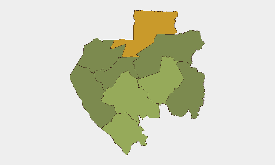
Woleu-Ntem Province (north) dominates sub-national risk (score 72) and warrants the highest operational attention; Ogooué-Lolo (southeast, score 58) and Ngounié Province (score 48) follow as secondary concern zones. These three regions collectively account for the country's elevated baseline risk profile, driven by remoteness, limited state presence, cross-border permeability (particularly toward Cameroon and Equatorial Guinea), and historical vulnerability to transnational crime and informal armed activity. By contrast, Estuaire Province (score 15), which contains Libreville and the main port, remains the safest major administrative zone. Organizations with personnel or assets in the north should prioritize risk differentiation and localized situational awareness; those based in or transiting through Libreville face materially lower exposure.
How GeoBit Would Assist
Security and duty-of-care teams monitoring Gabon should employ AOI (Area-of-Interest) Monitoring & Early Warning on Woleu-Ntem and Ogooué-Lolo to detect cross-border spillover from regional instability (DR Congo, CAR) with persistent alerting. Intel Sweep and multi-language OSINT fusion (including Telegram, X, local radio SIGINT) provide rapid event corroboration and sentiment tracking to distinguish signal from noise, as demonstrated by today's validation of rumor-level signals. Satellite & Imagery analysis and GIS & Spatial Analysis enable assessment of infrastructure, population movement, and informal activity in remote provinces where official reporting is sparse.
7-Day Outlook
No escalation in Gabon's security environment is forecast over the next seven days. Regional dynamics—particularly stability in neighboring Cameroon and Equatorial Guinea—remain the primary external variable; any acute instability in those zones could generate refugee flows or cross-border armed activity into Woleu-Ntem. Routine monitoring of northern provinces and persistent liaison with local partners should remain the baseline operational posture for at-risk organizations.
Highest-Risk Areas — Ranked
| # | State / Region | Risk |
|---|---|---|
| 1 | Woleu-Ntem | 72 |
| 2 | Ogooué-Lolo Province | 58 |
| 3 | Ngounié Province | 48 |
| 4 | Nyanga Province | 42 |
| 5 | Haut-Ogooué Province | 35 |
| 6 | Moyen-Ogooué Province | 28 |
| 7 | Ogooué-Maritime Province | 25 |
| 8 | Estuaire Province | 15 |
| 9 | Ogooué-Ivindo | 0 |
Sources
Previous Daily Briefs
A new Gabon brief is written every day — each with its own risk map and downloadable CSV. Here's the last week; use the calendar to go further back.
📅 Browse every day by calendar →
Highlighted days have a brief. Tap a day for that day's map & analysis, or “csv” for that day's dataset ($5).