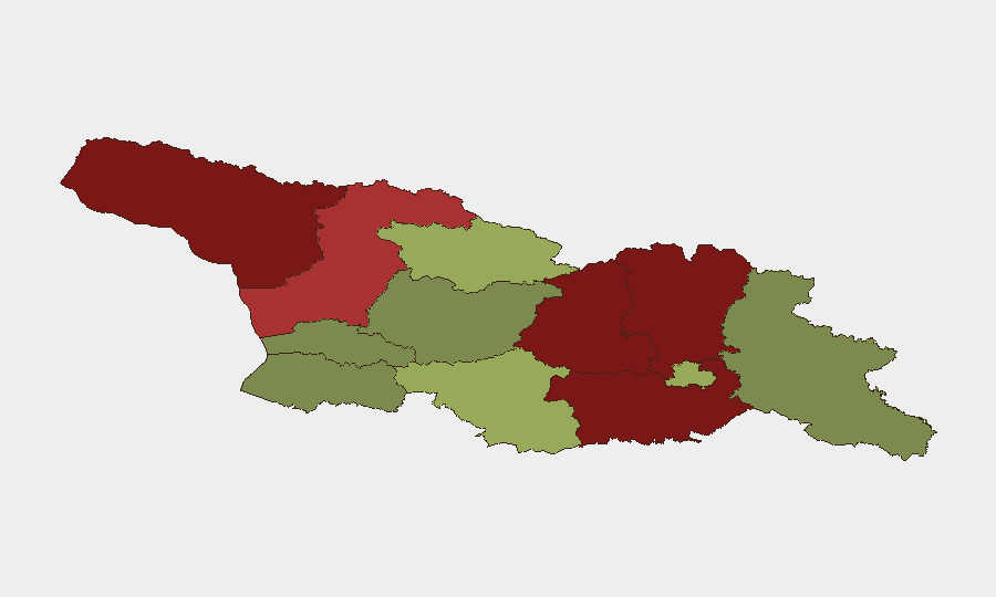
Situation Summary
Georgia's composite threat score of 14 places it in the lower-middle range globally, with security conditions heavily concentrated in contested and border-adjacent territories rather than major population centers. The two tracked events in the last 24–48 hours—a moderate earthquake (M 4.1 near Ambrolauri) and flood activity—are natural-hazard rather than conflict or civil-unrest driven, reflecting the current absence of acute political or criminal incidents in monitored feeds. However, persistent territorial disputes in the north (Abkhazia, South Ossetia) and militarized border regions maintain endemic risk that can spike without warning.
Key Developments
Natural Hazard Signals (Last 48h)
- Earthquake M 4.1 near Ambrolauri, Racha-Lechkhumi region (Shida Kartli oblast vicinity): moderate-magnitude seismic event; no immediate reports of significant damage or displacement in available feeds.
- Flood Event (ID 1103959) tracked in Georgia: geographic extent and severity unclear from current data; infrastructure and population impact unconfirmed in last 24–48 hours.
Data Limitation Notice
Open-source feeds monitored over the last 24–48 hours do not surface credible, timestamped reports of active conflict, civil unrest, crime incidents, political instability, or infrastructure failures in Georgia proper. Georgian-language and international media feeds should be consulted in parallel to this brief for on-the-ground verification.
Highest-Risk Areas
The Autonomous Republic of Abkhazia (risk 95) and the two Lower Caucasus regions of Shida Kartli (88) and Lower Kartli (85) dominate the risk landscape, driven by unresolved territorial control, military presence, and historical conflict dynamics. Abkhazia and the de facto South Ossetian territories remain outside Georgian government control, with Russian military posture and irregular armed groups sustaining persistent volatility. By contrast, Tbilisi (45), the economic and political hub, operates under significantly lower risk, as do western and southern regions (Guria, Imereti, Adjara), making them operationally safer for corporate activity and asset deployment.
How GeoBit Would Assist
A security team protecting personnel or assets in Georgia would deploy Intel Sweep and multi-language OSINT to monitor Georgian-language media, official statements, and social platforms for early warning of political, security, or infrastructure developments in real time. Conflict & Military battle mapping and force-structure tracking would provide persistent visibility into military posture in contested regions (Abkhazia, South Ossetia), while AOI monitoring with alerting on Tbilisi, key transport corridors, and border zones would flag incidents before they escalate. Satellite and imagery analysis, combined with economic & trade monitoring, would support supply-chain continuity and asset-location risk.
7-Day Outlook
No acute escalation indicators are visible in current feeds; however, the geopolitical position of Georgia and proximity to regional flashpoints (Russia-Ukraine, Turkey-Armenia dynamics) mean that secondary effects and diplomatic shifts can rapidly change local threat conditions. Teams should maintain standard monitoring and ensure evacuation or contingency protocols are current for high-risk northern regions, while continuing routine operations in Tbilisi and western Georgia with standard due-diligence protocols.
Highest-Risk Areas — Ranked
| # | State / Region | Risk |
|---|---|---|
| 1 | Autonomous Republic of Abkhazia | 95 |
| 2 | Shida Kartli | 88 |
| 3 | Lower Kartli | 85 |
| 4 | Mtskheta-Mtianeti | 82 |
| 5 | Samegrelo-Upper Svaneti | 78 |
| 6 | Samtskhe-Javakheti | 48 |
| 7 | Tbilisi | 45 |
| 8 | Racha-Lechkhumi and Kvemo Svaneti | 42 |
| 9 | Kakheti | 38 |
| 10 | Autonomous Republic of Adjara | 35 |
| 11 | Imereti | 32 |
| 12 | Guria | 28 |
Sources
Previous Daily Briefs
A new Georgia brief is written every day — each with its own risk map and downloadable CSV. Here's the last week; use the calendar to go further back.
📅 Browse every day by calendar →
Highlighted days have a brief. Tap a day for that day's map & analysis, or “csv” for that day's dataset ($5).