Situation Summary
Guyana faces a compound security crisis following the capsize of ferry MV Barima on 25 July with 179 aboard, leaving at least 27 dead and over 80 missing, alongside concurrent elevated threat activity along the Venezuela border. Search and recovery operations remain ongoing with a 1,040 km² search area, while separate armed engagements have been reported on the Cuyuni River within the past 24 hours. The national mourning declaration and investigative detention of ferry crew signal both crisis management and potential systemic governance concerns; simultaneous border incidents underscore persistent regional instability. Overall threat trajectory shows acute near-term risk concentrated in maritime and riverine frontier zones.
Key Developments
- MV Barima capsizing, offshore near Iron Punt – late 25 July 2026. Ferry en route Georgetown to Port Kaituma went down with ~179 persons aboard; confirmed 27 dead, 80+ missing. Official investigation initiated into negligence and crew drug use. Search area expanded to 1,040 km² as of 26 July; wreck located on seabed.
- Ferry captain and crew detention, Georgetown – 26 July 2026. Captain and at least one crew member tested positive for marijuana and were detained by authorities. Incident elevates concern over operational safety standards and crew vetting in maritime transport sector.
- National mourning declaration, Georgetown – 26 July 2026. Government declared three days of national mourning and ongoing emergency response measures, signaling potential service disruptions along Georgetown–Port Kaituma corridor.
- Opposition MP detention and equipment seizure, Charity, Region Two – 24 July 2026. MP Sherod Duncan detained while documenting victim families and disaster aftermath; police seized drone, camera, and other equipment. Reflects heightened sensitivity and law-enforcement activity in disaster zone.
- Armed attack on GDF personnel, Cuyuni River near Makapa Rapids (Guyana–Venezuela border) – within last 24 hours. GDF reported three separate small-arms attacks by armed men on Venezuelan shore against Guyanese patrols within a 24-hour window. No GDF casualties reported; force executed "measured responses." Indicates elevated cross-border armed activity and escalation risk.
- Recovery of GDF soldier's body, Cuyuni River – 25 July 2026. Lance Corporal Stefon Tudor recovered from river approximately 800 meters downstream from where he fell during border-zone operations on 23 July. Underscores operational hazard and sustained military activity in frontier region.
Highest-Risk Areas
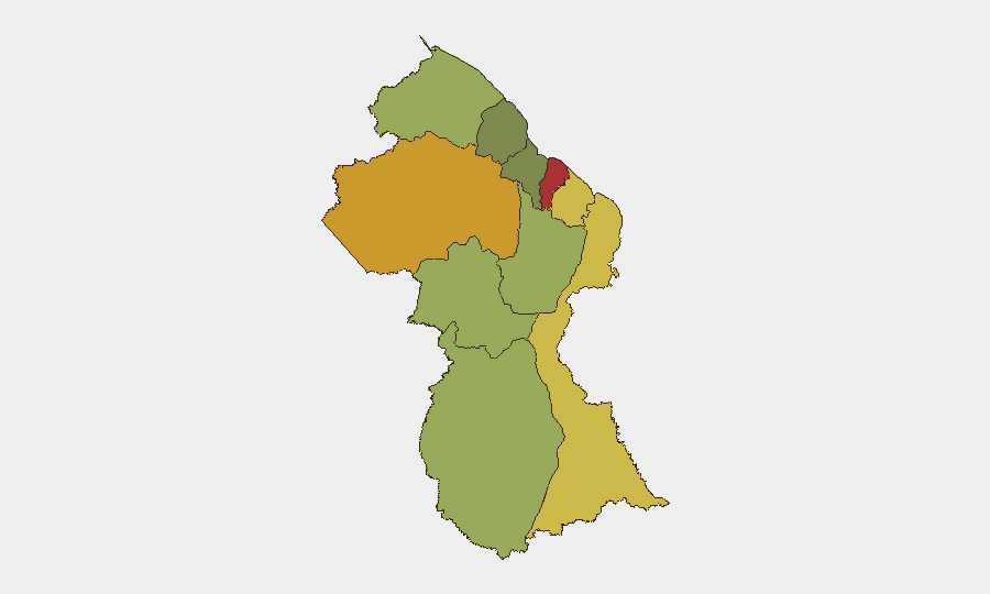
Demerara-Mahaica (risk 78) and Cuyuni-Mazaruni (risk 72) drive the national composite score. Demerara-Mahaica encompasses Georgetown and the immediate coastal zone where the MV Barima disaster, government operations, and maritime transport vulnerability are concentrated; Cuyuni-Mazaruni covers the Guyana–Venezuela border where armed incidents, GDF operations, and transnational security friction are active. Together these regions account for sustained investigative and law-enforcement activity. Mahaica-Berbice and East Berbice-Corentyne round out the highest-risk tier, reflecting broader eastern coastal and riverine exposure to maritime hazard and cross-border pressure.
How GeoBit Would Assist
Security teams managing personnel or assets in Guyana should activate AOI Monitoring & Early Warning on the Cuyuni River frontier and Georgetown maritime zone to capture further armed incidents and search-operation status. Maritime & Aviation tracking capabilities paired with OSINT fusion (X/Twitter, government statements, Telegram) would provide continuous updates on recovery progress and crew/investigative developments. Routing & Network Analysis would identify alternative transport corridors away from the now-disrupted Georgetown–Port Kaituma ferry route and assess safe passage options in high-risk Demerara-Mahaica and Cuyuni-Mazaruni regions.
7-Day Outlook
Search and recovery operations will likely dominate official and media focus through the end of the mourning period, with ongoing investigative and potential criminal proceedings against ferry crew. Border incidents on the Cuyuni River are probable to continue at current or elevated frequency, given historical pattern and absence of de-escalation signals. Corporate travel and maritime operations in coastal and riverine zones should assume disruption and heightened official scrutiny through early August.
Highest-Risk Areas — Ranked
| # | State / Region | Risk |
|---|---|---|
| 1 | Demerara-Mahaica | 78 |
| 2 | Cuyuni-Mazaruni | 72 |
| 3 | Mahaica-Berbice | 65 |
| 4 | East Berbice-Corentyne | 62 |
| 5 | Upper Demerara-Berbice | 58 |
| 6 | Potaro-Siparuni | 48 |
| 7 | Barima-Waini | 45 |
| 8 | Upper Takutu-Upper Essequibo | 42 |
| 9 | Pomeroon-Supenaam | 38 |
| 10 | Essequibo Islands | 35 |
Sources
Previous Daily Briefs
A new Guyana brief is written every day — each with its own risk map and downloadable CSV. Here's the last week; use the calendar to go further back.
📅 Browse every day by calendar →
Highlighted days have a brief. Tap a day for that day's map & analysis, or “csv” for that day's dataset ($5).
Atlas — our AI intelligence desk — emails them this snapshot personally. Nothing else, no list.