Situation Summary
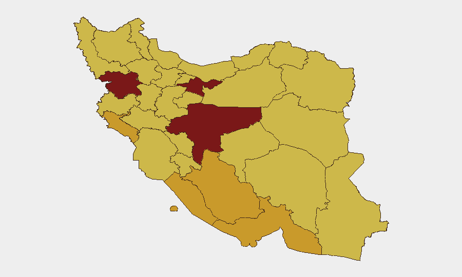
Iran remains the highest-tracked threat globally (composite score 100; 977 events), with acute escalation signals as of 6 June 2026. A conventional military exchange with Israel on 4 June, compounded by domestic political friction (presidential–parliamentary rejection signals, U.S. disapproval statements), and a UN investigation initiation on 6 June indicate multi-vector instability. Tehran and Isfahan provinces are the epicenters of risk, though unrest is distributed across 12 provinces. The trajectory is deteriorating rather than stabilizing.
Key Developments
- 6 June, nationwide: UN investigation initiated into Iranian activities (likely linked to military escalation or sanctions/weapons compliance).
- 6 June, unspecified location: Iranian militant rejection event; nature and parties unclear from signals but indicates intra-Iranian security fracturing.
- 4 June, unspecified location: Conventional military force exchange between Iran and Israel; no casualty/damage extent specified in available signals.
- 4 June, unspecified Iranian banking sector: Territory occupation event involving Iran and a financial institution; implications for asset access, sanctions enforcement, or operational control unclear.
- 4 June, domestic: Presidential–Senate rejection event, signaling legislative–executive breakdown on an unspecified policy matter (possibly war authorization, sanctions response, or security appointments).
- 4 June, Washington–Tehran: U.S. disapproval and threat statements directed at Iranian president and government; likely reaction to military escalation.
- 3 June, military–government: Iranian military rejection of government directive or policy; suggests command-and-control or doctrinal fracture.
Note: Older context (May–April 2026) includes U.S.–Iran negotiation activity and Iran-aligned militia strikes in Iraq, but these predate the current 48-hour window.
Highest-Risk Areas
Tehran Province (risk 100) and Isfahan Province (risk 99.7) are the primary risk drivers, reflecting capital-region political volatility, potential military installations, and concentration of foreign nationals and critical infrastructure. Kurdistan (85.2), Bushehr (72.6), and Ilam (72.3) provinces elevate risk through border proximity, militant activity, and energy-sector targets. The spread across 12 provinces—rather than concentration in one region—suggests systemic national instability rather than localized conflict, increasing unpredictability for asset protection and personnel safety planning.
How GeoBit Would Assist
Security teams would deploy Intel Sweep and multi-language OSINT (X/Twitter, Telegram, YouTube) to corroborate real-time signals of military, political, and militant movements and extract emerging actor networks. Area-of-Interest (AOI) Monitoring with alerting on Tehran, Isfahan, and border provinces would provide early warning of protest escalation, security force deployment, or militant mobilization. Conflict & Military battle mapping and force-structure tracking would clarify the scale and trajectory of Iran–Israel exchange and domestic command fractures, while Routing & Network Analysis would enable alternative journey planning for personnel in high-risk provinces and real-time asset relocation guidance.
7-Day Outlook
Without de-escalation signals, the Iran–Israel military exchange is likely to trigger Iranian retaliation cycles and international enforcement responses (UN investigation, sanctions review). Domestic political fracture (presidential–military–parliamentary misalignment) will impair crisis decision-making and increase the risk of uncontrolled militia or security-force action. Organizations with personnel or assets in Tehran, Isfahan, or border provinces should activate contingency protocols and intensify real-time monitoring.
Highest-Risk Areas — Ranked
| # | State / Region | Risk |
|---|---|---|
| 1 | Tehran Province | 100 |
| 2 | Isfahan Province | 99.7 |
| 3 | Kurdistan Province | 85.2 |
| 4 | Bushehr Province | 72.6 |
| 5 | Ilam Province | 72.3 |
| 6 | Fars Province | 72.1 |
| 7 | Hormozgan Province | 71.5 |
| 8 | Zanjan Province | 70.9 |
| 9 | Hamadan Province | 70.6 |
| 10 | Sistan and Baluchestan Province | 70.5 |
| 11 | North Khorasan Province | 70 |
| 12 | Razavi Khorasan | 70 |
Previous Daily Briefs
A new Iran brief is written every day — each with its own risk map and downloadable CSV. Here's the last week; use the calendar to go further back.
📅 Browse every day by calendar →
Highlighted days have a brief. Tap a day for that day's map & analysis, or “csv” for that day's dataset ($5).