Situation Summary
Iraq remains at composite threat level 15 globally, with insurgency as the primary driver (348 tracked events). The past 48 hours show elevated activity signals across military, diplomatic, and political domains, including cross-border military operations, aerial weapons employment, and escalating diplomatic tensions with Iran and the United States. Current trajectory reflects sustained operational tempo in conflict zones and deepening interstate friction that could constrain movement and increase collateral-risk exposure for corporate personnel and assets.
Key Developments
- 2026-06-05, Baghdad/National: Iraq issued formal disapproval statement directed at the United States, signaling diplomatic escalation on unspecified policy grounds. Timing suggests reactive posture to recent U.S. activity or statements.
- 2026-06-04, Al-Anbar/Border: Mexican military occupied Iraqi territory, marking unusual cross-border incursion. Scope, duration, and stated purpose remain unclear; suggests border-control breakdown or coordinated operation.
- 2026-06-04, Unspecified Maritime: Iraqi military forces engaged a cargo ship, indicating naval/maritime enforcement action or interdiction operation. Vessel status, cargo classification, and incident outcome not yet confirmed.
- 2026-06-03, Iran–Iraq Border: Iranian conventional military forces conducted operation into or against Iraqi positions. Suggests cross-border strike or incursion, consistent with historical pattern of Iranian IRGC activity in eastern Iraq.
- 2026-06-04, Unspecified (Student Actors): Aerial weapons deployed by student-identified actors against Iraqi military or civilian targets. High uncertainty on actor identity and intent; possible militant, militia, or drone operation.
- 2026-06-04, National: Iraq issued public disapproval statement on unspecified domestic or regional issue, separate from U.S.-directed disapproval. Tone and audience suggest internal policy disagreement or regional dispute.
- 2026-06-04, National: Iran issued two public statements directed at Iraq, indicating diplomatic messaging on bilateral or security issues. Timing and frequency suggest escalating rhetoric or formal protest.
Highest-Risk Areas
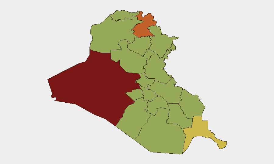
Al-Anbar Governorate (84.6) remains the highest-risk sub-national zone, driven by sustained insurgent activity and proximity to Syria. Erbil (75.2) and Baghdad (56.3) carry elevated risk from militia activity, cross-border Iranian operations, and political instability. The eastern border region—Maysan, Wasit, and Sulaymaniyah—faces persistent cross-border military pressure from Iran and Kurdish factional tensions. Southern governorates (Basra, Dhi Qar, Maysan) show elevated maritime and smuggling-related threat due to port infrastructure and Iranian proximity.
How GeoBit Would Assist
Teams with personnel or assets in Iraq should activate AOI Monitoring & Early Warning on high-risk governorates (Al-Anbar, Erbil, eastern border crossings) to detect military buildups, militia movements, or cross-border incursions in real time. Conflict & Military battle mapping and force-structure tracking will clarify the scale and actors involved in the 2026-06-03 Iran operation and ongoing border incidents. Network & Actor Analysis can map militia, state, and non-state military networks to assess collateral-risk exposure by facility or personnel location. Routing & Network Analysis enables identification of alternative movement corridors as primary roads face intermittent closures from operations.
7-Day Outlook
Cross-border Iranian military activity is likely to continue or intensify over the next week, particularly in Maysan and Wasit. Ongoing diplomatic tension with the United States and unresolved border incidents (Mexico, maritime) will sustain governmental messaging and potential unilateral military responses. Corporate duty-of-care protocols should assume sustained elevated threat in Al-Anbar, Erbil, and the eastern border zone through at least 2026-06-13.
Highest-Risk Areas — Ranked
| # | State / Region | Risk |
|---|---|---|
| 1 | Al-Anbar Governorate | 84.6 |
| 2 | Erbil Governorate | 75.2 |
| 3 | Al-Basra Governorate | 65.7 |
| 4 | Baghdad Governorate | 56.3 |
| 5 | Sulaymaniyah Governorate | 55.5 |
| 6 | Maysan Governorate | 55 |
| 7 | Saladin Governorate | 55 |
| 8 | Babil Governorate | 54.6 |
| 9 | Wasit Governorate | 54.6 |
| 10 | Al-Qadisiyah Governorate | 54.6 |
| 11 | Dhi Qar Governorate | 54.6 |
| 12 | Al-Muthanna Governorate | 54.6 |
Previous Daily Briefs
A new Iraq brief is written every day — each with its own risk map and downloadable CSV. Here's the last week; use the calendar to go further back.
📅 Browse every day by calendar →
Highlighted days have a brief. Tap a day for that day's map & analysis, or “csv” for that day's dataset ($5).