Situation Summary
Israel remains in active military conflict with Iran and Iranian-backed forces, with the South District experiencing the highest sustained threat. Over the past 48 hours, Iran has launched multiple missile barrages toward Israel, with Israeli air defenses conducting interceptions and Israeli forces responding with strikes in Iran. Domestic political friction is concurrent, with opposition statements and military-policy disputes evident in recent messaging.
Key Developments
- Northern Israel, Monday 9 June — IDF detected the sixth Iranian missile barrage since the latest flare-up began; Israeli air-defense systems activated to intercept incoming threats.
- Israel (national), Monday 9 June — Israeli forces conducted strikes in western and central Iran in response to Iranian missile launches, continuing the direct military exchange pattern established in recent days.
- Israel (national), Monday 9 June — Multiple air-defense alerts issued across the country as Iranian missiles were tracked and intercepted, affecting civilian alert protocols and movement patterns.
- Israel (domestic), 8 June — Opposition leader issued public disapproval statement regarding Israeli military policy; concurrent public statement by Israeli officials regarding military operations, indicating internal political debate.
- Sidon (Lebanon), 11 June — Israeli conventional military forces engaged targets in the southern Lebanese city, consistent with ongoing northern-border operations.
- Israel (national), 8 June — Israeli government appealed to the U.S. President, likely related to military support or coordination during the Iranian escalation.
Highest-Risk Areas
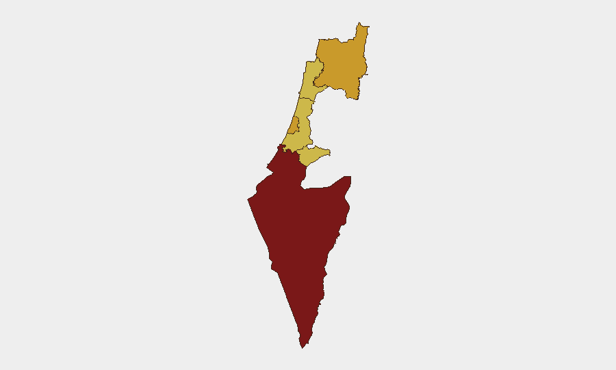
The South District (97.1) dominates the risk landscape and is the primary driver of Israel's global ranking, reflecting sustained cross-border fire and proximity to active conflict zones. The North District (72.1) and Tel-Aviv District (71.5) follow with elevated but notably lower composite scores, indicating secondary exposure to missile/drone activity and economic/infrastructure disruption. Jerusalem, Haifa, and Center Districts (67–68 range) carry moderate risk, primarily from indirect effects—air-defense operations, civil-alert protocols, and potential secondary incidents. The sharp risk gradient from south to north underscores that ground and rocket threats remain concentrated near the Gaza and Lebanon borders, while central and national-level risks stem from air-defense activation and political volatility.
How GeoBit Would Assist
Security and duty-of-care teams would deploy AOI Monitoring & Early Warning on South and North Districts to receive real-time alerts on missile launches, interceptions, and cross-border fire before impact. Conflict & Military capabilities (battle mapping, force structure, weapons-capability tracking) enable tracking of Iranian, Lebanese, and Israeli positions and capabilities to predict likely target corridors and escalation patterns. Routing & Network Analysis supports evacuation and alternative-journey planning for personnel in high-risk zones, while Satellite & Imagery Analysis confirms infrastructure damage and operational tempo to inform duty-of-care decisions on facility security and personnel movement.
7-Day Outlook
The Iran–Israel military cycle shows no sign of de-escalation; further Iranian barrages and Israeli counter-strikes are probable. Domestic political friction may increase pressure on military leadership, potentially affecting operational tempo or public messaging. The South District will remain the primary concern; corporate teams should maintain elevated alert protocols and contingency plans for 7–14 days.
Highest-Risk Areas — Ranked
| # | State / Region | Risk |
|---|---|---|
| 1 | South District | 97.1 |
| 2 | North District | 72.1 |
| 3 | Tel-Aviv District | 71.5 |
| 4 | Center District | 68.3 |
| 5 | Haifa District | 68.1 |
| 6 | Jerusalem District | 67.2 |
Sources
Previous Daily Briefs
A new Israel brief is written every day — each with its own risk map and downloadable CSV. Here's the last week; use the calendar to go further back.
📅 Browse every day by calendar →
Highlighted days have a brief. Tap a day for that day's map & analysis, or “csv” for that day's dataset ($5).