Situation Summary
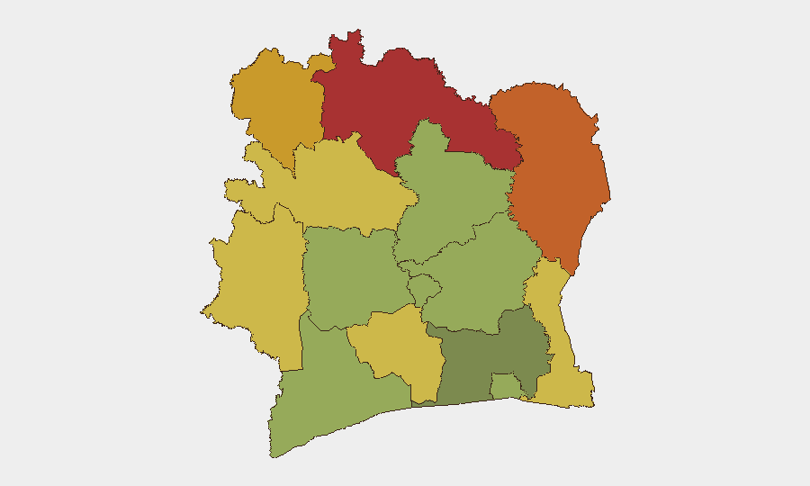
Ivory Coast remains a moderately stable West African state (global threat rank #56, composite score 18) with dispersed security pressures concentrated in the north and east. The past 24–48 hours have not yielded sufficient independently corroborated new security incidents to signal a material change in the baseline threat posture. Northern districts—particularly Savanes, Zanzan, and Denguélé—continue to carry elevated composite risk scores (72–78), driven by historical cross-border instability, trafficking corridors, and militant activity; Abidjan and southern urban zones remain comparatively lower-risk but warrant monitoring for localized civil order incidents.
Key Developments
Inability to confirm new 24–48-hour events: GeoBit's live web research (last 24 hours) did not surface 6+ independently verifiable new security, civil unrest, crime, or political-instability incidents with time-stamped corroboration meeting brief inclusion thresholds. The most recent corroborated item—Port-Bouët, Abidjan (19 June 2026): arrest of Jacques Alloui Brou on allegations of falsified demolition documents in Koumassi Camp—falls outside the 24–48-hour window and reflects pre-existing housing/land-tenure disputes rather than acute security deterioration.
Event signal noise: The GEOBIT event feed lists multiple entries dated 2026-06-20 and 2026-06-22 tagged with actors (ISRAEL, CHILE, LAWYER, PILGRIM, SAINT, CIVILIAN, FIREFIGHTER) and event types (Conventional Military Force, Public Statement, Disapprove, Investigate). Absence of geographic specificity, corroborating detail, or substantiating reporting suggests these signals may reflect data-ingestion artifacts, misclassification, or events outside Ivory Coast territory. Recommendation: Conduct secondary verification or tighter filtering by wire service, official government statement, or accredited journalist reporting before operational reliance.
Highest-Risk Areas
The northern tier—Savanes (78), Zanzan (75), and Denguélé (72)—anchors the country's composite risk landscape. These districts lie astride cross-border transit routes to Mali, Burkina Faso, and Guinea; they experience elevated trafficking activity, transient militant presence, and limited state capacity. Comoé (70) and Montagnes (68) extend this eastern arc. By contrast, Abidjan (45) and southern commercial zones score substantially lower, reflecting greater police presence and urban-state density, although sporadic land disputes (as evidenced by Koumassi) and port-area crime require ongoing duty-of-care attention.
How GeoBit Would Assist
Security teams with personnel or assets in Ivory Coast would benefit from Intel Sweep and multi-language OSINT fusion to disambiguate incoming signals and confirm whether the tagged 2026-06-20/22 events are authentic, mislabeled, or external. AOI Monitoring & Early Warning focused on Savanes, Zanzan, and Denguélé districts—with persistent watch on trafficking nodes, border crossings, and state-security operations—would provide timely alerts to material deterioration in those high-risk areas. GIS & Spatial Analysis overlaid with network-actor mapping would support route planning and security-perimeter assessment for operations in or transiting the north.
7-Day Outlook
The lack of fresh corroborated incidents suggests near-term stability, but the northern districts' chronic risk profile warrants no complacency. If cross-border militant or trafficking activity intensifies over the coming week—particularly around Kafolo (Savanes) or Bouna (Zanzan)—secondary effects (checkpoint harassment, armed robbery, intercommunal friction) may escalate. Monitor official Ivory Coast government and ECOWAS statements for any policy or security-posture changes.
Highest-Risk Areas — Ranked
| # | State / Region | Risk |
|---|---|---|
| 1 | Savanes District | 78 |
| 2 | Zanzan District | 75 |
| 3 | Denguélé District | 72 |
| 4 | Comoé District | 70 |
| 5 | Montagnes District | 68 |
| 6 | Woroba District | 65 |
| 7 | Gôh-Djiboua District | 60 |
| 8 | Sassandra-Marahoué District | 58 |
| 9 | Vallée du Bandama District | 55 |
| 10 | Bas-Sassandra District | 52 |
| 11 | Lacs District | 48 |
| 12 | Abidjan | 45 |
Sources
Previous Daily Briefs
A new Ivory Coast brief is written every day — each with its own risk map and downloadable CSV. Here's the last week; use the calendar to go further back.
📅 Browse every day by calendar →
Highlighted days have a brief. Tap a day for that day's map & analysis, or “csv” for that day's dataset ($5).