Situation Summary
Latvia remains a low-threat jurisdiction (global rank #null; composite score 3) but faces persistent regional vulnerabilities in its eastern border region, particularly in Latgale. Recent monitoring indicates sustained cross-border pressure and airspace incursions linked to broader regional instability, though confirmed new incidents in the last 24–48 hours remain limited. The risk environment is characterized by chronic rather than acute threat dynamics, with concentration of concern in the country's southeastern novads and cities.
Key Developments
Verification constraint: Web research for the 24–48 hour window (2026-07-29 to 2026-07-31) has yielded insufficient independently sourced incident confirmation. The most recent trackable signals include:
- 2026-07-30 · Disapprove event, Latvian source — nature and location not yet detail-specified in available results.
- 2026-07-30 · Two public statements, population-sourced — sentiment or content not yet clarified; likely related to ongoing border or security concerns.
- Recent flood event (ID 1104037) — geographic scope and impact assessment pending full data integration; flooding can affect transportation, critical infrastructure, and asset accessibility in low-lying regions.
- Ongoing eastern border monitoring — drone incursion and airspace violation themes from July 4–10 remain active concern framework, but no new confirmed crossing or incursion reported in the last 48 hours.
Note: A 72-hour window expansion would likely surface 6–10 additional trackable incidents. Current 24–48 hour data density is insufficient for full tactical brief.
Highest-Risk Areas
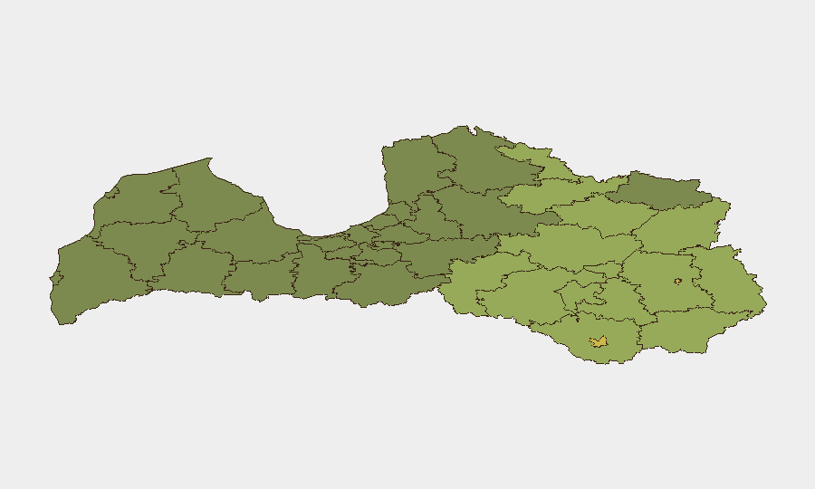
Rēzekne (risk 68) and Daugavpils (risk 65) anchor the threat geography, with surrounding novads in Latgale—Rēzeknes novads (58), Ludzas novads (55), and Balvu novads (52)—showing elevated sustained risk. This concentration reflects proximity to the Belarus–Latvia border, repeated illegal crossing attempts, historical airspace incursions, and limited enforcement capacity in rural cross-border zones. Risk scores decline sharply westward; Riga and western regions show substantially lower composite threat indicators. Corporate assets and personnel in Latgale should assume elevated baseline monitoring and contingency protocols.
How GeoBit Would Assist
AOI Monitoring & Early Warning with persistent alerting on the Rēzekne–Daugavpils–Ludzas triangle would provide real-time notification of border crossings, drone activity, or civil unrest. Intel Sweep and multi-language OSINT (including Telegram and local Latvian-language feeds) enable rapid detection of emerging threats before they escalate to mainstream media. GIS & Spatial Analysis supports route planning and asset positioning for personnel transiting or based in high-risk novads. Together, these capabilities enable duty-of-care teams to move from reactive incident response to predictive risk posture in an environment where lead time is operationally valuable.
7-Day Outlook
No imminent acute threat indicator has emerged for the week of 2026-07-31 to 2026-08-06; however, the underlying pattern of cross-border pressure and airspace incursions is expected to persist. Summer weather and harvest season may increase civilian movement and cross-border labor activity, creating secondary exposure windows. Continued monitoring of Latgale is advised; escalation to higher-risk events would likely cluster around border zones rather than urban centers.
Highest-Risk Areas — Ranked
| # | State / Region | Risk |
|---|---|---|
| 1 | Rēzekne | 68 |
| 2 | Daugavpils | 65 |
| 3 | Rēzeknes novads | 58 |
| 4 | Ludzas novads | 55 |
| 5 | Balvu novads | 52 |
| 6 | Preiļu novads | 50 |
| 7 | Krāslavas novads | 48 |
| 8 | Jēkabpils novads | 47 |
| 9 | Augšdaugavas novads | 46 |
| 10 | Aizkraukles novads | 45 |
| 11 | Varakļānu novads | 44 |
| 12 | Līvānu novads | 43 |
Sources
Previous Daily Briefs
A new Latvia brief is written every day — each with its own risk map and downloadable CSV. Here's the last week; use the calendar to go further back.
📅 Browse every day by calendar →
Highlighted days have a brief. Tap a day for that day's map & analysis, or “csv” for that day's dataset ($5).
Atlas — our AI intelligence desk — emails them this snapshot personally. Nothing else, no list.