Situation Summary
Lebanon remains in a fragile and deteriorating security posture following renewed military escalation in the south over the past 48 hours. The latest Israeli evacuation orders affecting hundreds of thousands of residents south of the Zahrani River, combined with the highest daily projectile exchange rate (670 movements) since the 17 April cessation-of-hostilities agreement, signal a significant breach of the nominal ceasefire. Displacement pressures are now acute in coastal urban centers, and humanitarian access constraints are compounding civilian vulnerability across South Lebanon.
Key Developments
- Southern Lebanon evacuation surge (3–4 June): UN OCHA reported new Israeli evacuation orders issued over the preceding 48 hours affecting hundreds of thousands south of the Zahrani River, driving fresh displacement into Tyre, Saida, and host communities.
- Projectile exchange spike (3 June): UNIFIL documented approximately 670 projectile movements on Wednesday—the highest daily figure since 17 April—alongside increased Israeli ground and air activity including strikes north of the Litani River.
- Shelter capacity breach (3–4 June): Collective shelters in Tyre and Saida reported full, with families seeking accommodation in host communities under conditions described by UN officials as "intolerable."
- Humanitarian access degradation (3–4 June): Families in newly designated evacuation zones reported fleeing on short notice without reliable access to food, shelter, healthcare, water, and sanitation; funding gaps and access constraints are limiting the humanitarian response.
- Multi-actor public statements (4–5 June): Concurrent public statements from the White House, Iran, the U.S. House of Representatives, and Lebanese officials, along with an Iranian rejection statement, suggest diplomatic tensions are running parallel to ground escalation.
- Militia and military force indicators (5 June): Signal events tracking conventional military force from militia and military actors, a military alert, and a rejection from Iran all recorded on 5 June, indicating active force posturing.
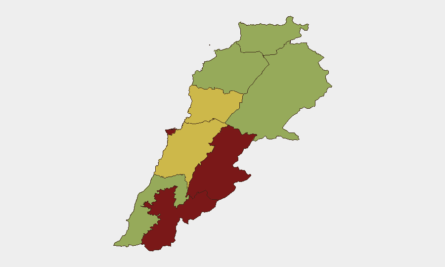
Highest-Risk Areas
Beqaa Governorate (89.1) and Beirut Governorate (86.8) drive the composite threat landscape, with South Lebanon's Nabatieh Governorate (81.8) now the primary focus of acute displacement and military activity. The coastal governorates—particularly around Tyre and Saida—face compounded risk from the convergence of sustained projectile exchanges, mass displacement, shelter saturation, and weakened humanitarian infrastructure. Mount Lebanon and northern governorates register moderate-to-elevated risk (59–61.5), reflecting secondary displacement routes and potential secondary-effects spillover from the southern escalation.
How GeoBit Would Assist
Corporate security teams with personnel or assets in Lebanon should deploy AOI Monitoring & Early Warning to track real-time displacement patterns and military activity concentration in Beqaa, Beirut, and South Governorates, with alert thresholds calibrated to evacuation-order issuance and projectile-exchange velocity. Routing & Network Analysis capabilities enable rapid alternative-route and safe-passage planning for personnel transiting Tyre–Saida corridors and inland routes during displacement surges. Conflict & Military battle mapping and force-structure tracking, combined with OSINT fusion (X/Telegram, news feeds, UN bulletins), provide near-real-time corroboration of ceasefire violations and military-posture shifts to inform duty-of-care decisions.
7-Day Outlook
Absent rapid diplomatic de-escalation or renewed enforcement of the ceasefire, the southern military activity is likely to sustain or intensify, driving further displacement northward and westward into urban centers already at shelter capacity. Monitor for secondary displacement bottlenecks on routes toward Beirut and Mount Lebanon, and for signals of Iranian or U.S. military repositioning that could reset the conflict trajectory.
Highest-Risk Areas — Ranked
| # | State / Region | Risk |
|---|---|---|
| 1 | Beqaa Governorate | 89.1 |
| 2 | Beirut Governorate | 86.8 |
| 3 | Nabatieh Governorate | 81.8 |
| 4 | Mount Lebanon Governorate | 61.5 |
| 5 | Keserwan-Jbeil Governorate | 60 |
| 6 | South Governorate | 59.3 |
| 7 | North Governorate | 59.1 |
| 8 | Akkar Governorate | 59.1 |
| 9 | Baalbek-Hermel Governorate | 59.1 |
Previous Daily Briefs
A new Lebanon brief is written every day — each with its own risk map and downloadable CSV. Here's the last week; use the calendar to go further back.
📅 Browse every day by calendar →
Highlighted days have a brief. Tap a day for that day's map & analysis, or “csv” for that day's dataset ($5).