Situation Summary
Lesotho remains a low-intensity threat environment with no active security crises or acute incidents reported in the last 24–48 hours. The country ranks #163 globally (composite threat score 5) with zero tracked events in the current reporting window. While sub-national risk concentration in Maseru and Mafeteng districts reflects underlying vulnerabilities in urban crime, informal settlement conditions, and cross-border dynamics with South Africa, the threat posture is stable and non-escalating.
Key Developments
- No new security incidents reported in Lesotho in the last 24–48 hours. Available open-source reporting is policy and economic-focused (digital infrastructure, AI adoption) rather than security-incident-focused.
- INTERPOL Operation First Light 2026 participation (Lesotho): Lesotho is among 97 nations in a multi-month anti-fraud and money-laundering campaign; the operation window (Jan–Apr 2026) has concluded, and this represents ongoing regulatory engagement rather than a new threat development.
- South African legal proceedings involving Lesotho nationals (Johannesburg, 9 July 2026): Three Lesotho nationals appeared in court regarding an older mass-shooting incident in Cleveland informal settlement; this is a legal proceeding in South Africa, not a new incident within Lesotho territory.
- No cross-border escalation, civil unrest, political instability, infrastructure disruption, or acute travel-risk events confirmed in the last 48 hours.
Highest-Risk Areas
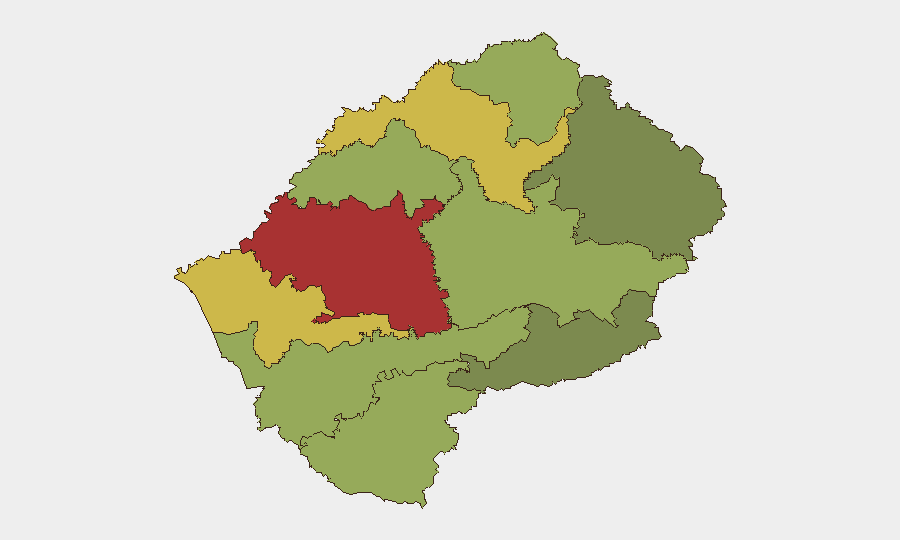
Maseru District (risk 78) and Mafeteng District (risk 65) dominate the sub-national risk profile and account for approximately 40% of the country's composite threat concentration. Maseru's elevated risk reflects the capital's exposure to urban crime, informal settlement volatility, and cross-border smuggling networks linked to South Africa; Mafeteng similarly exhibits crime and trafficking pressure. Leribe (62) and Berea (58) districts follow, indicating a geographic clustering of risk in the western and central lowlands where population density, informal economic activity, and South African proximity converge. Mokhotlong and Qacha's Nek districts in the southeastern highlands remain lower-risk, reflecting sparser population and geographic isolation.
How GeoBit Would Assist
Corporate security and duty-of-care teams operating in Lesotho should employ AOI (Area-of-Interest) Monitoring & Early Warning focused on Maseru and Mafeteng districts to detect emerging civil unrest, crime spikes, or informal-settlement incidents before they escalate. Network & Actor Analysis and OSINT Fusion & Corroboration (cross-referencing X/Twitter, Telegram, YouTube, and local radio SIGINT) would provide early signals of labor unrest, political friction, or cross-border trafficking activity. GIS & Spatial Analysis and Routing & Network Analysis enable real-time alternative-route planning and venue avoidance for personnel and asset movements, particularly in high-risk districts.
7-Day Outlook
No significant change in the Lesotho security posture is anticipated over the next seven days. The country remains stable with routine governance and economic activity; risk concentrations are chronic rather than acute. Monitoring should remain routine, with heightened alertness to informal-settlement incidents and South African spillover effects, particularly ahead of any announced political or labor events.
Highest-Risk Areas — Ranked
| # | State / Region | Risk |
|---|---|---|
| 1 | Maseru District | 78 |
| 2 | Mafeteng District | 65 |
| 3 | Leribe District | 62 |
| 4 | Berea District | 58 |
| 5 | Mohale's Hoek District | 52 |
| 6 | Butha-Buthe District | 48 |
| 7 | Thaba-Tseka District | 45 |
| 8 | Quthing District | 42 |
| 9 | Mokhotlong District | 38 |
| 10 | Qacha's Nek District | 28 |
Sources
Previous Daily Briefs
A new Lesotho brief is written every day — each with its own risk map and downloadable CSV. Here's the last week; use the calendar to go further back.
📅 Browse every day by calendar →
Highlighted days have a brief. Tap a day for that day's map & analysis, or “csv” for that day's dataset ($5).
Atlas — our AI intelligence desk — emails them this snapshot personally. Nothing else, no list.