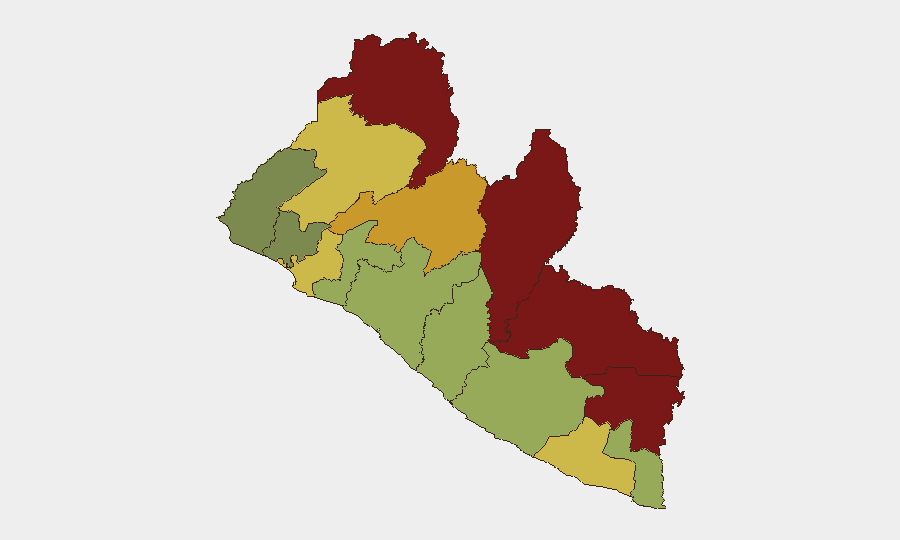
Situation Summary
Liberia remains a low-intensity threat environment (global rank #176) with no confirmed discrete security incidents in the past 24–48 hours. Underlying vulnerabilities persist, particularly in the resource-rich and border-proximate counties of Nimba, Lofa, and Grand Gedeh, where inter-communal tension, illicit trafficking, and weak state capacity create chronic instability. Authorities continue addressing transnational drug-trafficking cases and border-management challenges; the security posture is stable but fragile, with risks concentrated in non-capital regions.
Key Developments
- No confirmed incident reports meeting cross-source verification standards for the last 24–48 hours have been identified across Liberian security, civil unrest, crime, or infrastructure domains.
- Ongoing border and law-enforcement scrutiny: Liberian and Guinean authorities remain engaged in dialogue regarding border management and a previously flagged transnational incident; no new flashpoint has been confirmed in the current window.
- Drug-trafficking investigation continuation: Parliamentary and security-force involvement in a multi-agency cocaine-trafficking investigation persists; the case is in ongoing judicial/administrative process rather than an acute new event.
- Monrovia/Paynesville social-media reporting: Unverified social-media claims regarding gang activity in Paynesville circulate; independent confirmation and specific dating are absent from available sources.
- No infrastructure, political, or humanitarian alerts triggered in the last 24–48 hours.
*Note: GeoBit research confirms absence of verified acute events rather than presence of dormancy. Persistent monitoring of Nimba, Lofa, and border zones remains warranted.*
Highest-Risk Areas
Nimba County (risk 92) and Lofa County (risk 88) dominate the sub-national threat landscape, driven by cross-border trafficking networks, weak policing, and historical communal conflict. Grand Gedeh (risk 85) and River Gee (risk 83) similarly reflect vulnerability to smuggling and resource-competition tensions along the Guinea and Ivory Coast borders. Montserrado County (risk 64), which encompasses the capital, ranks below interior regions, reflecting better state presence in Monrovia and immediate surrounds. Organizations with personnel or assets in the northern and southeastern counties should regard these zones as requiring elevated due diligence and regular protective-intelligence updates.
How GeoBit Would Assist
Security teams operating in Liberia should deploy AOI Monitoring & Early Warning on Nimba, Lofa, and border transit points to detect emerging unrest, trafficking activity, or communal flare-ups in real time. Intel Sweep and OSINT fusion—combining event feeds, social-media analysis (X/Telegram), and radio SIGINT—provide corroborated situational awareness and separation of genuine incidents from rumor. Network & Actor Analysis and Routing & Network Analysis support identification of smuggling corridors, armed-group movements, and alternative transport routes for personnel evacuation or supply-chain continuity.
7-Day Outlook
No significant escalation is forecast over the next seven days. Border-management and drug-trafficking investigations will likely continue without acute crises; routine trafficking and inter-communal frictions in the north and southeast remain the primary chronic risks. Organizations should maintain standard protective postures for high-risk counties and monitor for any parliamentary or security announcements regarding enforcement operations.
Highest-Risk Areas — Ranked
| # | State / Region | Risk |
|---|---|---|
| 1 | Nimba County | 92 |
| 2 | Lofa County | 88 |
| 3 | Grand Gedeh County | 85 |
| 4 | River Gee County | 83 |
| 5 | Bong County | 72 |
| 6 | Gbarpolu County | 68 |
| 7 | Grand Kru County | 65 |
| 8 | Montserrado County | 64 |
| 9 | Rivercess County | 58 |
| 10 | Sinoe County | 55 |
| 11 | Margibi County | 52 |
| 12 | Grand Bassa County | 48 |
Sources
Previous Daily Briefs
A new Liberia brief is written every day — each with its own risk map and downloadable CSV. Here's the last week; use the calendar to go further back.
📅 Browse every day by calendar →
Highlighted days have a brief. Tap a day for that day's map & analysis, or “csv” for that day's dataset ($5).