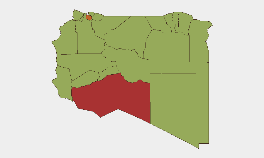
Situation Summary
Libya remains moderately elevated in global risk rankings (26th, composite score 70.1) with 44 tracked threat events, reflecting a fragile and tense security environment centered on Tripoli and southern border regions. Recent event signals point to mounting institutional friction—arrests of activists and foreign nationals, presidential rejections of proposals, and military force deployments—alongside investigative action by both state and private entities. The security picture suggests friction between state authority and non-state actors, compounded by military posturing around the capital that has drawn UN concern. Overall trajectory remains volatile but non-acute absent major tactical escalation.
Key Developments
- 2026-06-06 · Tripoli/Military – Conventional military force deployment reported in connection with Muammar Gaddafi reference; exact nature, scale, and command structure require clarification through urgent open-source corroboration.
- 2026-06-05 · National – Presidential rejection of unspecified proposal; institutional context unclear but signals policy friction at executive level.
- 2026-06-05 · Arrests (dual) – Libya detained a Tunisian national; separately, activist arrest documented. Pattern suggests heightened detention activity targeting both foreign and domestic opposition figures.
- 2026-06-06 · Border/Movement – Expulsion or deportation of traveller(s) by African entity; likely related to border-control or migration enforcement rather than direct security threat, but indicates tightened movement controls.
- 2026-06-05 · Prison & Secretariat – Public statements tied to prison and Libyan Secretariat; implies potential custody-related transparency or administrative dispute.
- 2026-06-05 · Corporate Investigation – Private company under investigation by Libyan authorities; sector and company identity unconfirmed; suggests potential regulatory or sanctions-related action.
- 2026-06-04 · Activism/Demands – Activist-led demand(s) recorded; no casualty or violence indicator, but marks continued civil-society friction.
Caveat: The signals above derive from GeoBit event feeds with limited open-source detail on 48-hour specifics. Precise incident scope, casualties, and operational implications require real-time OSINT corroboration and X/Telegram monitoring.
Highest-Risk Areas
Murzuq (79.1) and Jafara (73.1) dominate sub-national risk; both lie in southern and western Libya, historically prone to smuggling, militia activity, and border instability. Tripoli (56.1), despite lower rank, remains operationally critical given population density, capital function, and reported recent military buildups. Sirte (50.1) and a cluster of southern/western districts at 49.1 risk reflect persistent armed-group presence, porous borders, and limited state capacity. Risk concentration in the south and west—rather than east—marks a shift from 2023–24 patterns and warrants monitoring of supply-route changes and militia consolidation.
How GeoBit Would Assist
Security teams should activate AOI Monitoring & Early Warning on Tripoli, Murzuq, and Jafara with real-time alerting for military movement, detention activity, and public statements. OSINT Fusion (X, Telegram, local media, YouTube) would clarify the military deployment on 2026-06-06, identify activist networks under pressure, and track corporate investigation outcomes. Network & Actor Analysis would map detention targets and institutional fault lines, while Intel Sweep (event feeds + multi-language search) would sustain 48–72-hour event visibility ahead of duty-of-care briefings.
7-Day Outlook
Expect continued friction between state authority and activists/opposition; arrest frequency may remain elevated. Military posturing around Tripoli poses risk of accidental escalation if competing armed groups interpret deployments as territorial challenge. No indication of imminent large-scale violence, but deterioration in rule-of-law environment and tightening of movement controls will increase compliance and evacuation-planning burden for international operators.
Highest-Risk Areas — Ranked
| # | State / Region | Risk |
|---|---|---|
| 1 | Murzuq | 79.1 |
| 2 | Jafara | 73.1 |
| 3 | Tripoli | 56.1 |
| 4 | Sirte | 50.1 |
| 5 | Nalut | 49.1 |
| 6 | Ghat | 49.1 |
| 7 | Baladiyah Surman | 49.1 |
| 8 | Az Zawiya District | 49.1 |
| 9 | Wadi al Shatii | 49.1 |
| 10 | Wadi al Hayaa | 49.1 |
| 11 | Kufra | 49.1 |
| 12 | Nuqat al Khams | 49.1 |
Sources
Previous Daily Briefs
A new Libya brief is written every day — each with its own risk map and downloadable CSV. Here's the last week; use the calendar to go further back.
📅 Browse every day by calendar →
Highlighted days have a brief. Tap a day for that day's map & analysis, or “csv” for that day's dataset ($5).