Situation Summary
Libya remains a fragmented security environment with persistent militia presence, weak central authority, and localized instability. As of mid-July 2026, the country ranks #19 globally in composite threat score (95/100) with 30 tracked events. Recent political activity—including diplomatic engagement on army unification and US envoy engagement—has not yet translated into measurable security improvements. The threat landscape is driven by actors spanning governance disputes, intelligence operations, and regional power competition rather than acute kinetic escalation in the past 48 hours.
Key Developments
- Political/Diplomatic Activity (14–15 July): Multiple public statements from government representatives, intelligence officials, and international actors (including references to US involvement) flagged in open reporting, reflecting ongoing governance and diplomatic tensions but without confirmed security incidents tied to these statements.
- Intelligence Operations (15 July): Arrest or detention reported involving intelligence actors and a consulate; public statements from intelligence officials regarding counter-terrorism posture. Specific location and verified details remain limited in open sources.
- Activist Assassination (15 July): One assassination event targeting an activist recorded in event signals. Geographic specificity and operational context not yet confirmed in corroborated reporting.
- Military Movement/Positioning (14 July): Conventional military force activity noted in signals; aligns with background context of ongoing 12 July military-leadership meetings in Sirte on unification, but no new discrete kinetic incidents confirmed for the 24–48-hour window.
- Trader Disapproval / Public Sentiment (15 July): Commercial or trader-related disapproval signal recorded; underlying cause and location unclear from available open sources.
- Media/Publisher Statement (16 July, today): Public statement between Libyan actors and publisher flagged; nature and implications not yet detailed in accessible reporting.
Note: Open-source verification for the last 24–48 hours remains sparse. Most signals are captured via event aggregation but lack independent multi-source confirmation or precise timestamps and locations. This reflects both genuine security lull and reporting gaps typical of Libya's fragmented media landscape.
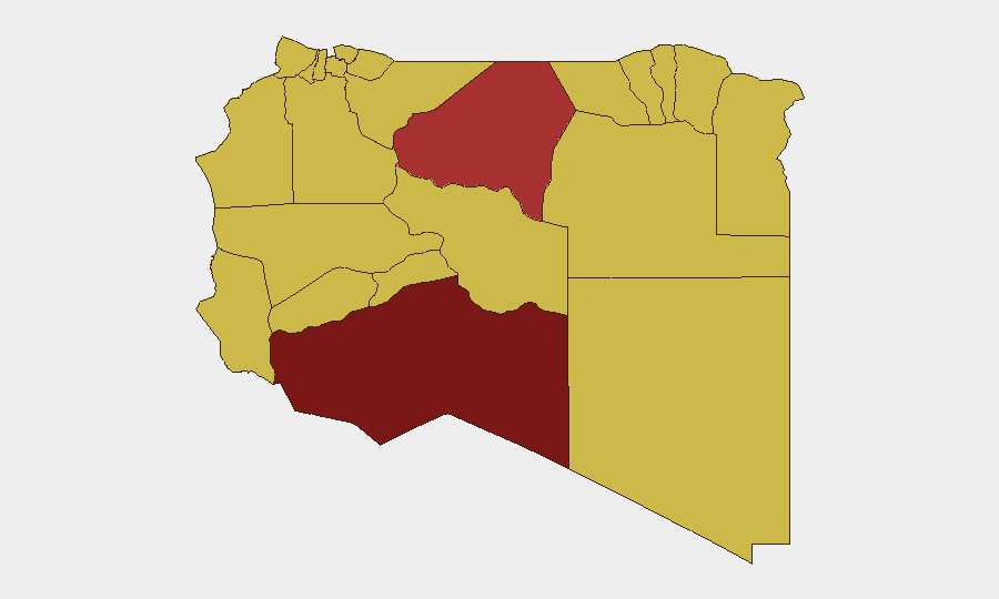
Highest-Risk Areas
Murzuq (risk 96.2) emerges as the single highest-risk administrative area, followed by Sirte (76.2) and the capital Tripoli (67.1). The southern region—encompassing Murzuq, Ghat, Kufra, and Wadi al Shatii—carries elevated risk tied to remote governance capacity, militia fragmentation, and cross-border smuggling networks. Sirte and Tripoli remain focal points for rival power centers and military/intelligence activity. The consistency of risk scores across 12 lower-ranked zones (66.2) suggests widespread diffuse instability rather than concentrated hotspots, with criminality, militia presence, and weak law enforcement spanning coastal and interior regions alike.
How GeoBit Would Assist
Security teams should deploy AOI Monitoring & Early Warning on Murzuq, Sirte, and Tripoli for persistent threat detection with automated alerting on violence, checkpoints, or force movement. Network & Actor Analysis and OSINT fusion (multi-language X/Telegram/YouTube intelligence combined with radio SIGINT) would triangulate the actors behind the recent public statements and intelligence operations, clarifying escalation risk. GIS & Spatial Analysis paired with satellite imagery would track militia positioning and checkpoint density in high-risk zones, enabling duty-of-care routing and facility security posture updates.
7-Day Outlook
Expect continued low-level political and intelligence signaling without dramatic escalation in the near term, contingent on ongoing diplomatic engagement. However, the persistent militia fragmentation and governance disputes in southern regions create sustained kidnapping, robbery, and extortion risk for travelers and assets. Any breakdown in the diplomatic track—or military unification talks in Sirte—could rapidly re-activate factional tensions.
Highest-Risk Areas — Ranked
| # | State / Region | Risk |
|---|---|---|
| 1 | Murzuq | 96.2 |
| 2 | Sirte | 76.2 |
| 3 | Tripoli | 67.1 |
| 4 | Nalut | 66.2 |
| 5 | Ghat | 66.2 |
| 6 | Baladiyah Surman | 66.2 |
| 7 | Az Zawiya District | 66.2 |
| 8 | Wadi al Shatii | 66.2 |
| 9 | Wadi al Hayaa | 66.2 |
| 10 | Kufra | 66.2 |
| 11 | Nuqat al Khams | 66.2 |
| 12 | Jafara | 66.2 |
Sources
Previous Daily Briefs
A new Libya brief is written every day — each with its own risk map and downloadable CSV. Here's the last week; use the calendar to go further back.
📅 Browse every day by calendar →
Highlighted days have a brief. Tap a day for that day's map & analysis, or “csv” for that day's dataset ($5).
Atlas — our AI intelligence desk — emails them this snapshot personally. Nothing else, no list.