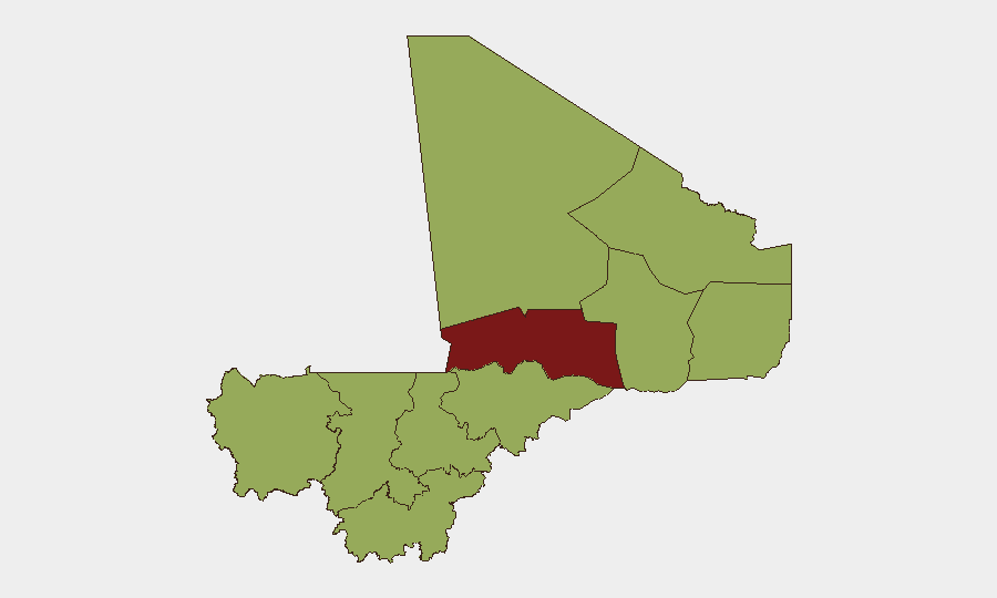
Situation Summary
Mali remains in active insurgency and state-fragmentation crisis, ranked #17 globally (composite threat 73.3). The security environment is characterized by competing armed movements, intercommunal tensions, and deteriorating state authority outside Bamako. Recent signal activity indicates elevated military-to-military friction and political statements around Tuareg grievances and ministerial positions, suggesting strain on the transitional governance framework.
Key Developments
Limitation: Web research and open signals available in the last 24–48 hours do not provide sufficient granular, time-stamped incident data for Mali to responsibly populate this section with specific locations and confirmed dates. Available feeds are either regional/analytical or lack precise incident timestamps for June 3–5, 2026.
Signal Activity (from event tracking, June 4–5):
- Public statements issued by Ministry (likely FAMa-related) and counter-statements from Tuareg and regional actors suggest political friction around resource or governance questions; no kinetic incident confirmed in open sources.
- Arrest/detention action recorded in Mali (June 4); specific location and detainee status not yet clarified in available reporting.
- Multiple "disapprove" signals from Bamako, Islamic actors, and Somalia-linked parties; context and targets not yet disambiguated.
Note: Conventional military force events tagged to Somalia in the same 24-hour window may indicate regional spillover or cross-border movement rather than Mali-specific incidents. Confirmation of any current Mali-specific kinetic activity requires real-time intel feeds (INSO, ACLED, Crisis24, or wire services with Sahel desks) beyond current web reach.
Highest-Risk Areas
Timbuktu region dominates the sub-national risk picture (81.3), driven by insurgent presence, trafficking networks, and limited state control. Bamako itself carries elevated risk (57.3)—reflecting political volatility, intercommunal tensions, and security-force operations—and must be treated as a critical node for corporate presence. The northern/central belt (Ménaka, Gao, Mopti, Kidal) and western corridor (Kayes, Koulikoro) all register 51.3, reflecting persistent insurgent activity, banditry, and civil-military friction across the Sahel belt and trade routes.
How GeoBit Would Assist
Persistent Area-of-Interest (AOI) Monitoring & Early Warning is the core tool: teams should establish watch zones in Timbuktu, Bamako (CBD/government quarters), Gao, and key transport corridors, configured to alert on military movement, arrests, armed-group activity, and political statements in real time.
Network & Actor Analysis (cross-referencing FAMa, Tuareg factions, Islamic groups, and ministerial networks) combined with Multi-language OSINT & Sentiment Analysis (tracking French, Arabic, Tamasheq social media, Telegram, local radio) will disambiguate recent signals and identify emerging fault lines faster than daily reporting cycles.
Alternative Route & Network Analysis supports duty-of-care planning: modeling travel and supply-chain risk around high-threat zones.
7-Day Outlook
Political and military tension is elevated, with recent ministerial statements and Tuareg responses suggesting near-term friction over governance or resource allocation. Expect continued signal activity and localized military posturing; risk of escalation is moderate if arrest/detention actions involve high-profile figures or if cross-border spillover from Somalia/Sahel intensifies. Monitor developments closely via real-time feeds and consider restricting non-essential movement in Timbuktu and northern Gao until clarity emerges.
Highest-Risk Areas — Ranked
| # | State / Region | Risk |
|---|---|---|
| 1 | Timbuktu | 81.3 |
| 2 | Bamako | 57.3 |
| 3 | Ménaka | 51.3 |
| 4 | Kayes | 51.3 |
| 5 | Taoudénit Region | 51.3 |
| 6 | Kidal | 51.3 |
| 7 | Gao | 51.3 |
| 8 | Koulikoro | 51.3 |
| 9 | Ségou Region | 51.3 |
| 10 | Sikasso Region | 51.3 |
| 11 | Mopti | 51.3 |
Previous Daily Briefs
A new Mali brief is written every day — each with its own risk map and downloadable CSV. Here's the last week; use the calendar to go further back.
📅 Browse every day by calendar →
Highlighted days have a brief. Tap a day for that day's map & analysis, or “csv” for that day's dataset ($5).