Situation Summary
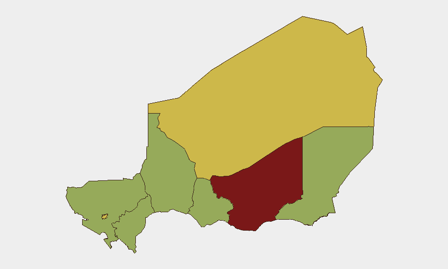
Niger remains ranked #30 globally (composite threat score 72) with persistent instability concentrated in the Zinder Region and along northern and western borders. Recent event signals suggest active military operations, detention activity, and isolated violence, though open-source reporting from the past 24–48 hours remains limited and fragmented. The security environment continues to reflect long-standing drivers: militant activity in border zones, inter-state tensions, and localized criminal threats. Overall trajectory is stable but fragile, with elevated risk concentrated in specific geographic pockets rather than nationwide escalation.
Key Developments
- Military activity reported (2026-06-13, location unconfirmed): Conventional military force engagement involving Nigerian and MALE (Multinational Armed Forces Liaison Element or similar designation) actors; open-source confirmation pending precise coordinates.
- Detention and diplomatic response (2026-06-14, Niamey area): A spokesman was arrested or detained in relation to Nigeria-linked allegations; UK disapproval statement issued simultaneously, suggesting diplomatic friction over detention practices or cross-border governance.
- Media criticism of security operations (2026-06-14): Media outlets published disapproval of Nigerian (or Nigerian-led) operations; context and geographic scope require further corroboration.
- Criminal threat escalation (2026-06-12): Nigerian state actor issued threats toward criminal organizations; suggests organized crime activity or gang-related violence in at least one populated area.
- Educational institution incident (2026-06-12, location unconfirmed): Unconventional violence (insurgent or militant attack) directed at a school; no casualty or abduction data confirmed in available open-source reporting as of 14 June.
- Possible hostage/abduction event (2026-06-14, location unconfirmed): Abduction or hostage-taking by Nigerian nationals reported; details insufficient to determine whether domestic or cross-border in nature.
Note: Open-source web and social-media corroboration for specific locations and casualty counts within the past 48 hours is currently sparse. The GeoBit platform event feed reflects aggregated signals; field verification and local-source confirmation are recommended for operational decision-making.
Highest-Risk Areas
Zinder Region dominates the sub-national ranking (80.4), reflecting a combination of militant activity, trafficking routes, and weak state capacity. Agadez and Niamey tie at 65.4, indicating security concerns in the north (extractive industries, migrant flows, remote terrain) and the capital (political sensitivity, foreign presence, law-enforcement operations). The remaining six regions cluster at 50.4, suggesting baseline risk from crime, border permeability, and insurgent recruitment but no acute flashpoint. Risk concentration in Zinder and the north-central corridor warrants priority for asset and personnel protection protocols.
How GeoBit Would Assist
Intel Sweep and multi-language OSINT fusion enable real-time aggregation of reports across French, Arabic, and English media and social platforms to surface events like detentions and military activity faster than single-source monitoring. AOI Monitoring & Early Warning on Zinder, Agadez, and Niamey permits persistent watch with automated alerting on militant movement, checkpoints, or civil unrest. Conflict mapping, force-structure analysis, and border & disputed-territory search help security teams understand militant group presence, military deployment patterns, and cross-border flow—critical for route planning and risk stratification of personnel movements.
7-Day Outlook
Expect continued low-to-moderate event frequency without escalation to nationwide crisis; localized military operations and law-enforcement actions will likely persist in Zinder and border zones. Diplomatic friction with Nigeria may drive heightened border scrutiny and temporary restrictions on cross-border movement. Monitor Agadez for migrant-trafficking disruptions and Niamey for political statement activity.
Highest-Risk Areas — Ranked
| # | State / Region | Risk |
|---|---|---|
| 1 | Zinder Region | 80.4 |
| 2 | Agadez Region | 65.4 |
| 3 | Niamey | 65.4 |
| 4 | Diffa Region | 50.4 |
| 5 | Tillabéri Region | 50.4 |
| 6 | Tahoua Region | 50.4 |
| 7 | Dosso Region | 50.4 |
| 8 | Maradi Region | 50.4 |
Sources
Previous Daily Briefs
A new Niger brief is written every day — each with its own risk map and downloadable CSV. Here's the last week; use the calendar to go further back.
📅 Browse every day by calendar →
Highlighted days have a brief. Tap a day for that day's map & analysis, or “csv” for that day's dataset ($5).