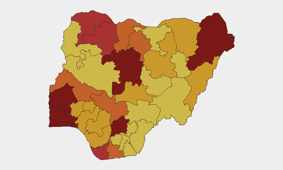
Situation Summary
Nigeria remains the world's highest-threat environment (composite score 100), driven by active insurgency, widespread banditry, and kidnapping networks across multiple regions. The past 48 hours have seen a spike in both security-force operations and criminal activity, with successful hostage rescues offset by continued abductions and armed clashes along major transport corridors. Civil unrest is building around governance and insecurity concerns, with nationwide protests planned around mid-June Democracy Day, adding political volatility to an already fractured security landscape.
Key Developments
- Mandara Mountains, southern Borno State (7–8 June, confirmed 11 June): Joint Nigerian military operation freed approximately 360–428 hostages from Boko Haram/JAS faction, largest coordinated rescue in recent weeks.
- Lokoja–Abuja Highway, Kogi State (11 June): Armed bandits clashed with police near Jamata, leaving at least four dead and multiple injured; sustained gunfire caused traffic disruption on critical north–south corridor.
- Kabba–Bunu axis, rural Kogi State (11 June): Bandits engaged security forces and vigilantes in prolonged firefight, triggering resident displacement; reflects persistent rural bandit networks.
- Southern Kaduna–Plateau forest corridors (10–11 June): Military clearance operations disrupted kidnap gangs and freed dozens of abductees over 48-hour period.
- Kebbi and Katsina States (11 June): Security tracker recorded 11 separate incidents in 24 hours, including kidnapping of local politicians and abduction of army general with spouse.
- Jos South–Barkin Ladi, Plateau State (10–11 June): Troops foiled attempted abduction of pastor and spouse; kidnappers engaged and weapons recovered.
- Abuja/Federal Capital Territory (11 June): Civil-society coalitions announced 48-hour nationwide strike and protest action under #EndBadGovernance, demanding scrutiny of security spending; risk of demonstrations during Democracy Day observance.
- Cyber threats (13 June): Multiple Nigeria-linked digital assets flagged in cyber-threat monitoring; specific victims not yet disclosed but indicate elevated cyber-risk concurrent with physical threats.
Highest-Risk Areas
Borno State (score 100) and Kaduna State (95.9) remain the primary drivers of Nigeria's global threat ranking, with active Boko Haram/JAS operations and bandit networks entrenched in rural and mountainous terrain. Lagos (89.3) and Oyo (88.3) present urban crime and kidnapping risks, while Kogi (75.7), despite ranking lower, has emerged as a volatile transit and bandit corridor affecting the critical Lokoja–Abuja highway. The concentration of risk in the north and north-central belt reflects ongoing state weakness, porous borders, and inadequate security-force capacity; however, the recent spread of incidents to urban and commercial hubs (Lagos, Abuja, Plateau) signals widening operational reach by criminal networks.
How GeoBit Would Assist
Security teams should employ AOI (Area-of-Interest) Monitoring & Early Warning to track ongoing activity in Borno, Kaduna, Kogi, and Plateau with real-time alerting on military operations, bandit clashes, and abductions. Routing & Network Analysis is essential for staff and supply movements, identifying safer alternatives to the Lokoja–Abuja corridor and other high-incident highways. Network & Actor Analysis combined with OSINT feeds can track kidnap gangs, ransom demands, and hostage patterns to inform negotiation and recovery protocols.
7-Day Outlook
Bandit and insurgent activity will likely persist along rural corridors and within Borno–Kaduna belt; military clearance operations appear to be sustaining tempo but have not achieved decisive disruption. Planned mid-June protests and Democracy Day observances risk intersecting with security incidents in urban centers, particularly Abuja, and may trigger ad-hoc road closures or curfews. Travel restrictions on key highways (Lokoja–Abuja, southern Kaduna routes) should be anticipated for the next week.
Highest-Risk Areas — Ranked
| # | State / Region | Risk |
|---|---|---|
| 1 | Borno State | 100 |
| 2 | Kaduna State | 95.9 |
| 3 | Lagos State | 89.3 |
| 4 | Oyo State | 88.3 |
| 5 | Enugu State | 82.8 |
| 6 | Ogun State | 82 |
| 7 | Anambra State | 81.5 |
| 8 | Federal Capital Territory | 80.3 |
| 9 | Sokoto State | 79.5 |
| 10 | Bayelsa State | 78.2 |
| 11 | Zamfara State | 78 |
| 12 | Kogi State | 75.7 |
Sources
Previous Daily Briefs
A new Nigeria brief is written every day — each with its own risk map and downloadable CSV. Here's the last week; use the calendar to go further back.
📅 Browse every day by calendar →
Highlighted days have a brief. Tap a day for that day's map & analysis, or “csv” for that day's dataset ($5).