Situation Summary
North Korea remains at composite threat rank #30 globally (59.9), with 21 tracked events in the current monitoring cycle. The information environment remains highly closed; routine incidents, civil unrest, and infrastructure failures are not reported in real time and surface weeks or months later through defector testimony, satellite imagery, or intelligence assessment. No credibly confirmed, time-stamped security incidents, cross-border attacks, major political developments, or infrastructure failures have been reported in open sources for the last 24–48 hours.
Key Developments
No verified incidents meeting time-stamped, location-specific criteria have been identified in the last 24–48 hours. Open reporting over this window reflects ongoing policy commentary and medium-term trends (Russia–DPRK military cooperation, nuclear infrastructure activity, constitutional developments) rather than discrete, date-located security events inside North Korea. Analysts monitor satellite imagery and IAEA assessments of nuclear sites such as Yongbyon, but these assessments remain on a scale of weeks to months, not recent hours. Accounts tracking DPRK developments via social platforms and news services over the past 1–2 days focus predominantly on analysis and historical context rather than verifiable new incidents with clear location and date stamps.
Where alleged internal events surface in single-source reporting, they lack cross-confirmation and do not meet corporate security standards for inclusion in operational briefs.
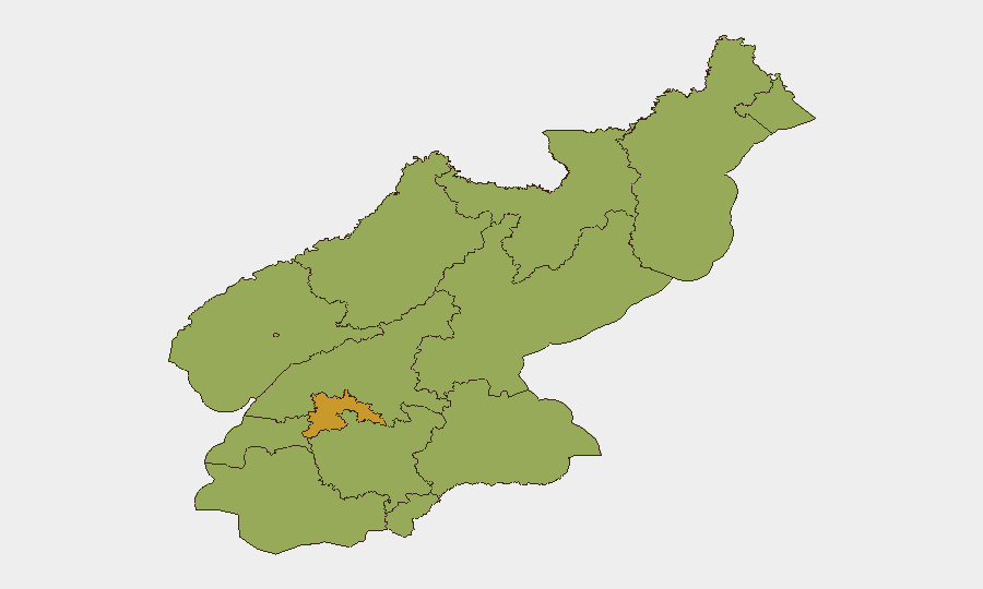
Highest-Risk Areas
P'yŏngyang dominates the sub-national risk picture (71.9), reflecting its role as the political and administrative center and concentration of state security apparatus, foreign presence, and sensitive infrastructure. South Pyongan (59.9) follows at the second tier, likely reflecting proximity to the capital, transportation hubs, and military facilities. The remaining provinces cluster at 41.9, indicating relatively more uniform baseline risk across the periphery, with the exception of the four highest-ranked zones. Risk elevation in P'yŏngyang and South Pyongan is consistent with structures of state control, foreign national presence, and operational concentration; peripheral regions present chronic structural risks (isolation, limited emergency response, restricted movement) rather than acute incident density.
How GeoBit Would Assist
Security teams with personnel or assets in North Korea should employ AOI Monitoring & Early Warning on P'yŏngyang and key infrastructure sites (Yongbyon, Nampo port, border regions) to detect emerging activity or imagery changes. Intel Sweep and multi-language OSINT (X/Twitter, Telegram, international wire services, think-tank feeds) provide the fastest detection of policy shifts, sanctions changes, or rare open-source incident reports. Satellite & Imagery Analysis paired with persistent monitoring of known military and nuclear sites offers the most reliable near-real-time window into operational tempo and regime stability signals.
7-Day Outlook
No imminent acute security incident is anticipated based on current reporting. Medium-term monitoring should focus on Russia–DPRK military coordination, nuclear and missile test activity at established sites, and any policy statements affecting foreign nationals or foreign business. Border regions and maritime zones around Nampo warrant continuous watch for trafficking, interdiction events, or cross-border incidents that may surface with delay.
Highest-Risk Areas — Ranked
| # | State / Region | Risk |
|---|---|---|
| 1 | P'yŏngyang | 71.9 |
| 2 | South Pyongan | 59.9 |
| 3 | North Pyongan | 53.9 |
| 4 | Ryanggang | 41.9 |
| 5 | North Hamgyong | 41.9 |
| 6 | Chagang | 41.9 |
| 7 | Nampo | 41.9 |
| 8 | South Hwanghae | 41.9 |
| 9 | North Hwanghae | 41.9 |
| 10 | South Hamgyong | 41.9 |
| 11 | Kaesong | 41.9 |
| 12 | Kangwon | 41.9 |
Previous Daily Briefs
A new North Korea brief is written every day — each with its own risk map and downloadable CSV. Here's the last week; use the calendar to go further back.
📅 Browse every day by calendar →
Highlighted days have a brief. Tap a day for that day's map & analysis, or “csv” for that day's dataset ($5).