Situation Summary
The Philippines faces a composite threat score of 35 (global rank #55), driven primarily by political instability in Metro Manila and the Cordillera Administrative Region, compounded by recent cyber-attacks on national institutions, ongoing maritime tensions in the West Philippine Sea, and persistent seismic aftershocks across Mindanao. Diplomatic friction with China, Spain, Taiwan, and Bahrain—evident in demand letters, arrests, and public statements over the past 48 hours—has elevated state-level tensions. Near-term security posture is volatile, with heightened protest risk coinciding with Independence Day observances and demonstrated willingness by state and non-state actors to escalate.
Key Developments
- Manila (Pasay City) – Senate website defaced by NullSec Philippines – 13 June 2026
The Philippine Senate's official website was taken offline after hacktivists claiming the NullSec Philippines identity defaced multiple pages. This represents a politically motivated cyber-attack on a key national institution and signals vulnerability in critical government digital infrastructure.
- Metro Manila – Heightened security posture and protest advisory – 13 June 2026
Philippine authorities have deployed additional checkpoints and police personnel following Independence Day (12 June) events, amid reports of a destabilization plot. UK Foreign Office guidance currently warns of large-scale demonstrations expected over coming weeks across Metro Manila, with associated traffic disruption risk.
- West Philippine Sea (Scarborough Shoal) – Chinese floating platform with suspected surveillance role – disclosed 11–12 June 2026
Philippine authorities confirmed discovery of a 6×6-meter floating structure with antenna apparatus inside disputed Scarborough Shoal waters. A formal diplomatic protest has been lodged with China; U.S. intelligence is actively monitoring the platform, elevating confrontation risk in the waterway.
- Mindanao (multiple provinces) – Ongoing earthquake response and aftershock risk – continuing as of 13 June 2026
The 7.8 magnitude earthquake of 8 June has caused dozens of fatalities and significant infrastructure damage. Search and rescue operations remain active; aftershock and tsunami risks persist, particularly in coastal and inland areas. UK travel advisory (current 13 June) advises avoidance of damaged infrastructure and compliance with local evacuation orders.
- Mindanao & Sulu Archipelago – No improvement in terrorism and insurgency risk – current as of 13 June 2026
UK Foreign Office continues to advise against all travel to western/central Mindanao and the Sulu archipelago, and against all but essential travel to remaining Mindanao regions, due to active terrorist and insurgent activity. The persistence of this advisory reflects an unchanged high-threat environment.
- Nationwide aviation – Indirect travel disruption from Middle East escalation – current as of 13 June 2026
Flight delays and cancellations affecting departures from the Philippines have resulted from wider Middle East instability, impacting corporate travel planning even for non-Middle East destinations.
Highest-Risk Areas
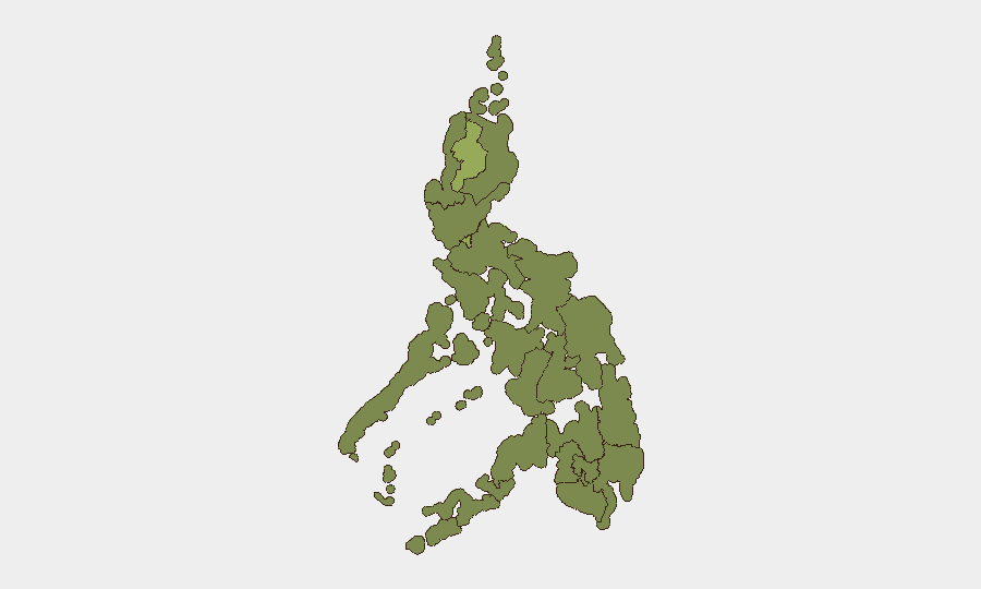
Metro Manila (54.1) and the Cordillera Administrative Region (53.5) dominate the risk profile. Metro Manila's elevation reflects political instability, heightened protest activity around Independence Day, recent cyber-attacks on state institutions, and sustained diplomatic tensions. The Cordillera's elevated score reflects military/police activity and ongoing tensions. Secondary-tier regions (Mimaropa, Soccsksargen, Calabarzon) remain moderately elevated; Mindanao sub-regions show lower absolute scores despite persistent terrorism and earthquake aftershock hazards, likely because GeoBit's composite methodology weights recent political/cyber events heavily in the current period.
How GeoBit Would Assist
Security teams should deploy AOI Monitoring & Early Warning on Metro Manila political hotspots and West Philippine Sea maritime zones to detect protest mobilization and Chinese platform activity in real time. Conflict & Military tracking paired with Network & Actor Analysis (including social-media OSINT on NullSec and other activist groups) would provide early warning of further cyber or physical destabilization attempts. Routing & Network Analysis supports contingency planning for personnel in earthquake-affected Mindanao and congested Metro Manila during heightened security periods.
7-Day Outlook
Political and cyber tensions are likely to remain elevated through mid-June as Independence Day aftermath subsides and protest calendars solidify. Maritime confrontation risk in the West Philippine Sea will persist at current levels pending diplomatic resolution on the Chinese platform. Seismic aftershock frequency is expected to decline, but recovery operations and infrastructure instability will constrain normal operations in affected Mindanao areas for 1–2 weeks.
Highest-Risk Areas — Ranked
| # | State / Region | Risk |
|---|---|---|
| 1 | Metro Manila | 54.1 |
| 2 | Cordillera Administrative Region | 53.5 |
| 3 | Mimaropa | 33.5 |
| 4 | Soccsksargen | 30.8 |
| 5 | Calabarzon | 30.8 |
| 6 | Ilocos Region | 28.1 |
| 7 | Central Luzon | 26.8 |
| 8 | Davao Region | 25.5 |
| 9 | Zamboanga Peninsula | 25.5 |
| 10 | Western Visayas | 25.5 |
| 11 | Bangsamoro | 24.1 |
| 12 | Caraga | 24.1 |
Sources
Previous Daily Briefs
A new Philippines brief is written every day — each with its own risk map and downloadable CSV. Here's the last week; use the calendar to go further back.
📅 Browse every day by calendar →
Highlighted days have a brief. Tap a day for that day's map & analysis, or “csv” for that day's dataset ($5).