Situation Summary
Saint Lucia remains a moderate-risk jurisdiction (global rank #75) with elevated sub-national crime concentration in the capital and northern districts. The Royal Saint Lucia Police Force reported a "significant decline in overall crime" through 2 July 2026, though homicides and gun violence persist as primary concerns. No major security incidents, civil unrest, or infrastructure failures have been reliably verified in the last 24–48 hours; underlying risk reflects first-half 2026 trends rather than acute current events.
Key Developments
- No verified incident-level events recorded in Saint Lucia within the last 24–48 hours with reliable timestamps and multi-source corroboration. General crime and homicide concerns remain elevated but are not tied to specific dated incidents on 6–7 July 2026.
- Early-July crime trend (as of 2 July 2026): RSLPF released statistics confirming "significant decline in overall crime between January 1 and July 2, 2026," indicating no acute crisis declared by authorities as of that date.
- Island-wide police operations (early July, date unspecified): Law enforcement reported conducting a "sweeping island-wide crime operation" targeting illegal firearms and violent offenders across multiple districts; exact timing and outcome details remain unclear from available open-source reporting.
- Homicide spike noted in first half of 2026: Police and local media describe a 25% rise in homicides year-to-date and reference a "surge in gun violence in recent days," but these reports lack precise timestamps placing incidents within 6–7 July.
- Road-traffic risk remains structural: Over 95,000 vehicles operate on an island of ~180,000 population, with approximately 3,000 crashes reported in the past year; no specific transport incidents confirmed in the last 24–48 hours, but congestion and accident risk remain elevated on primary routes.
- Regional stability confirmed (4–5 July): Monitoring of neighboring Eastern Caribbean jurisdictions detected no major armed conflict, political violence, or critical infrastructure failures; no cross-border incidents affecting Saint Lucia.
Highest-Risk Areas
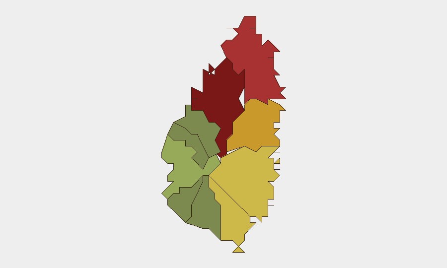
Castries (risk 95) and Gros Islet (risk 78) drive the national composite threat score, reflecting concentrated gun violence, gang activity, and street crime in the capital and northern coastal districts. Dennery (72), Vieux Fort (68), and Micoud (65) form a secondary risk tier tied to similar drivers. Southern and western districts (Soufrière, Laborie, Choiseul, Anse La Raye, Canaries) present significantly lower risk profiles. Corporate personnel and logistics assets in or transiting Castries face the highest operational exposure; northern maritime and tourism operations (Gros Islet) warrant standard crime-prevention protocols.
How GeoBit Would Assist
Security teams should deploy Intel Sweep and OSINT Fusion to monitor Castries, Gros Islet, and secondary risk zones for emerging gun violence, gang activity, or infrastructure disruption with real-time alerting. AOI Monitoring & Early Warning on Castries port facilities, main commercial districts, and accommodation clusters would provide persistent awareness of unplanned security events. Routing & Network Analysis enables duty-of-care teams to identify alternative transport corridors and safe passage planning around high-risk districts during operational travel.
7-Day Outlook
Violent crime is expected to remain the dominant risk vector, with gun violence and gang activity likely persisting at current elevated levels through mid-July absent major law-enforcement escalation. Weather and road-traffic incidents pose secondary but consistent hazard risk. No indicators suggest imminent large-scale civil unrest, political instability, or regional security degradation.
Highest-Risk Areas — Ranked
| # | State / Region | Risk |
|---|---|---|
| 1 | Castries | 95 |
| 2 | Gros Islet | 78 |
| 3 | Dennery | 72 |
| 4 | Vieux Fort | 68 |
| 5 | Micoud | 65 |
| 6 | Soufrière | 42 |
| 7 | Laborie | 38 |
| 8 | Choiseul | 35 |
| 9 | Anse La Raye | 28 |
| 10 | Canaries | 12 |
Sources
Previous Daily Briefs
A new Saint Lucia brief is written every day — each with its own risk map and downloadable CSV. Here's the last week; use the calendar to go further back.
📅 Browse every day by calendar →
Highlighted days have a brief. Tap a day for that day's map & analysis, or “csv” for that day's dataset ($5).
Atlas — our AI intelligence desk — emails them this snapshot personally. Nothing else, no list.