Situation Summary
Saint Vincent and the Grenadines presents a low-to-moderate composite threat profile (global rank #189, threat score 3) with no tracked security events in the current reporting window. No major incidents—civil unrest, infrastructure disruption, crime spikes, or travel emergencies—were detected in open regional media or social channels during the last 24–48 hours. The security environment remains stable at the national level, though sub-national risk concentration in Saint George and Saint Andrew parishes warrants focused asset monitoring.
Key Developments
No discrete security incidents meeting confirmation criteria (official reporting, regional news corroboration, or time-stamped social media evidence) were identified in Saint Vincent and the Grenadines during 11 July 2026 or the preceding 48 hours.
Highest-Risk Areas
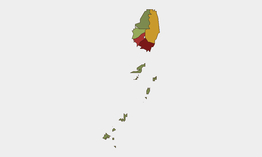
Saint George (composite risk 92) and Saint Andrew (78) account for the largest share of measured sub-national risk, followed by Charlotte (71). These parishes, which include or neighbor the capital Kingstown and its commercial/port zones, carry elevated exposure to localized crime, gang activity, and infrastructure vulnerabilities typical of densely populated Caribbean urban centers. Saint Patrick (58) and Saint David (34) show measurably lower risk profiles. The Grenadines (12) remain the lowest-risk zone. Organizations with personnel or critical assets in Saint George and Saint Andrew should maintain standard duty-of-care protocols, including incident reporting networks and transportation security awareness, but no acute threat spike is evident.
How GeoBit Would Assist
AOI Monitoring & Early Warning can establish persistent surveillance of high-risk parishes (Saint George, Saint Andrew, Charlotte) with automated alerting if new incidents—crime, unrest, infrastructure failure—emerge; this provides advance notice before corporate exposure widens. OSINT Fusion & Corroboration (multi-language search, X/Twitter monitoring, regional news feeds) cross-references local police bulletins, Caribbean news outlets, and social channels to validate and timestamp incidents in real time, preventing reliance on unconfirmed or misdated reports. Risk & Threat Assessment and Network & Actor Analysis support mapping of crime networks, gang territories, and corruption nodes within high-risk parishes to inform travel routing, site hardening, and staff briefing. Routing & Network Analysis generates alternative transport routes that avoid known incident clusters or infrastructure weak points.
7-Day Outlook
No imminent acute security triggers are apparent in current reporting. The near-term trajectory is expected to remain stable, consistent with the established low-to-moderate threat baseline, barring unplanned natural disaster (hurricane/volcanic activity) or a sudden breakdown in local order. Continuous OSINT and AOI monitoring are recommended to catch early signals of gang violence escalation or political friction that could affect the capital or main commercial zones within 7–14 days.
Highest-Risk Areas — Ranked
| # | State / Region | Risk |
|---|---|---|
| 1 | Saint George | 92 |
| 2 | Saint Andrew | 78 |
| 3 | Charlotte | 71 |
| 4 | Saint Patrick | 58 |
| 5 | Saint David | 34 |
| 6 | Grenadines | 12 |
Sources
Previous Daily Briefs
A new Saint Vincent brief is written every day — each with its own risk map and downloadable CSV. Here's the last week; use the calendar to go further back.
📅 Browse every day by calendar →
Highlighted days have a brief. Tap a day for that day's map & analysis, or “csv” for that day's dataset ($5).
Atlas — our AI intelligence desk — emails them this snapshot personally. Nothing else, no list.