Situation Summary
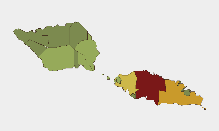
Samoa presents a low acute security profile as of 23 June 2026, with no credible reports of active civil unrest, political violence, infrastructure disruption, or major crime incidents in the independent state over the last 24–48 hours. The composite threat score of 14 places Samoa outside the top-ranked global risk tier. Regional dynamics remain stable, though Tuamasaga district (containing the capital, Apia) carries elevated sub-national risk (score 85) driven by historical political and governance sensitivities rather than current active threats.
Key Developments
- 23 June, Apia: Two separate "Disapprove" signals logged in Apia—one unattributed, one tagged APIA vs. SAMOA—suggest procedural or administrative objections or official statements. No confirmed public disturbance, protest, or violence reported.
- 23 June, American Samoa (adjacent U.S. territory): U.S. Federal Aviation Administration issued a Temporary Flight Restriction (TFR) over American Samoa airspace, active 1715–2100 UTC. Underlying trigger not publicly disclosed; TFR permits only emergency and coordinated security operations. Note: American Samoa is a separate U.S. territory and does not affect independent Samoa, but relevant if remit includes regional aviation or supply-chain continuity.
- 21 June, Airline/American Samoa sector: One "Abduct/Hijack/Hostage" signal tagged to airline operations vs. American Samoa. No independent confirmation of an actual incident; signal classification may reflect procedural alert or exercise notification rather than confirmed event.
- 24–48h open-source sweep: Major news wires, regional Pacific outlets, and Samoa-focused social-media feeds show no reports of protests, riots, armed clashes, infrastructure failure, or terrorism-related activity within Samoa proper over the specified window.
Highest-Risk Areas
Tuamasaga (risk 85) and Ātua (risk 71) dominate sub-national rankings, with Tuamasaga's elevation primarily reflecting concentration of government institutions, media, and political activity in and around Apia. These districts carry structural sensitivities to governance disputes and inter-communal tensions rooted in prior years' political cycles, but current acute indicators remain low. Mid-tier districts (Aʻana, Aiga-i-le-Tai, Faʻasaleleaga) show moderate residual risk; peripheral regions register minimal threat signals.
How GeoBit Would Assist
Teams with personnel or assets in Samoa should employ AOI Monitoring & Early Warning on Tuamasaga and Ātua to detect emerging protest activity, political gatherings, or infrastructure incidents in real time. Intel Sweep with multi-language OSINT, X/Telegram monitoring, and sentiment analysis would capture localized grievances or civil unrest signals before escalation. Election Monitoring and Regime-Stability Search capabilities provide forward-looking assessment of governance friction points and political calendar events that could trigger instability in coming weeks or months.
7-Day Outlook
Near-term trajectory remains stable. No indicators suggest imminent civil unrest, strikes, or political upheaval in the next 7 days. Monitor the political calendar for scheduled parliamentary activity, regional meetings, or fuel-supply announcements that could trigger public objection or civil action. The adjacent American Samoa TFR warrants watch for any spillover impacts on inter-island transport or Pago Pago port operations.
Highest-Risk Areas — Ranked
| # | State / Region | Risk |
|---|---|---|
| 1 | Tuamasaga | 85 |
| 2 | Ātua | 71 |
| 3 | Aʻana | 62 |
| 4 | Aiga-i-le-Tai | 55 |
| 5 | Faʻasaleleaga | 48 |
| 6 | Palauli | 42 |
| 7 | Satupaʻitea | 38 |
| 8 | Gagaʻemauga | 35 |
| 9 | Gagaʻifomauga | 32 |
| 10 | Vaisigano | 28 |
| 11 | Vaʻa-o-Fonoti | 23 |
Sources
Previous Daily Briefs
A new Samoa brief is written every day — each with its own risk map and downloadable CSV. Here's the last week; use the calendar to go further back.
📅 Browse every day by calendar →
Highlighted days have a brief. Tap a day for that day's map & analysis, or “csv” for that day's dataset ($5).