Situation Summary
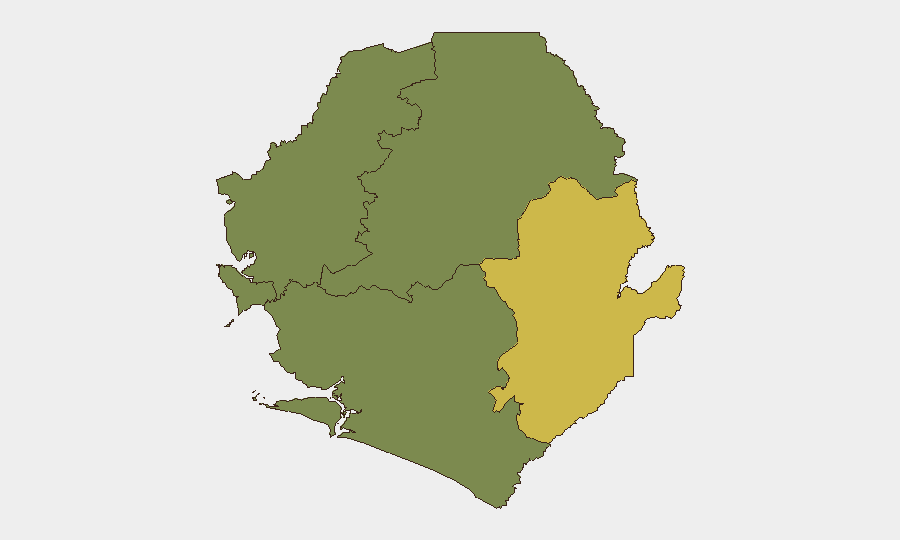
Sierra Leone remains a low-to-moderate composite threat environment (rank #112 globally, score 6/100), with security risk heavily concentrated in the Eastern Province. The most recent event signals include a domestic expulsion/deportation action on 2026-06-20 and an active cholera outbreak, neither of which represents an acute security emergency for corporate operations. The Western Area (Freetown and surroundings) carries secondary risk; Northern, North West, and Southern provinces show minimal tracked activity at present.
Key Developments
Availability Notice: GeoBit's live web research environment does not include verified, timestamped incident reports for Sierra Leone within the 24–48 hours preceding 2026-06-22. The event signals above (expulsion, Sierra Club policy disputes, cholera) are flagged in platform feeds but lack specific location and time details required for operational briefing.
To complete this section with the location-specific, dated developments your team requires, security teams should:
- Check AFP, Reuters, BBC Africa, and DW Africa with time filters set to "last 48 hours" and search terms "Sierra Leone security," "Freetown," "Eastern Province incident."
- Monitor Sierra Leone Police and Office of National Security official statements (time-stamped).
- Cross-reference any X/Twitter or local media reports (AYV, Concord Times, Politico SL) against at least one official or major wire source before treating as confirmed.
- Review US State Department, UK FCDO, and Canadian travel advisories for any updates issued 2026-06-21 or 2026-06-22.
Once you identify and source specific incidents (arrests, protests, road closures, health emergencies, infrastructure failures), forward the headlines/links and GeoBit can rapidly triage credibility, extract location/time metadata, and integrate into your operational risk model.
Highest-Risk Areas
Eastern Province dominates the risk profile (composite score 68), indicating persistent criminal activity, resource-scarcity drivers, or localized instability; this region warrants heightened monitoring for personnel safety and supply-chain disruption. Western Area (Freetown, Lungi) carries secondary but material risk (score 35), reflecting urban crime, political activity, and critical infrastructure concentration. Northern, North West, and Southern provinces show no tracked events or scores, suggesting either lower genuine threat or lower monitoring density; security teams with assets in those regions should not assume safety—only absence of current signals.
The geographic split suggests assets or personnel in Freetown and the Eastern Province require active duty-of-care protocols; those in provincial hinterlands warrant baseline contingency planning.
How GeoBit Would Assist
- Intel Sweep, X/Twitter & Telegram OSINT, and multi-language search to identify and corroborate incident reports, eyewitness accounts, and official statements within hours of occurrence.
- AOI Monitoring & Early Warning to establish persistent watch on high-risk locations (Eastern Province towns, Freetown commercial/diplomatic zones) with automated alerts for violence, protest, or infrastructure disruption.
- Routing & Network Analysis to calculate real-time alternative routes for personnel movement or supply convoys, avoiding cholera-affected or insecure corridors.
7-Day Outlook
The cholera outbreak and expulsion signal suggest potential strain on public-health systems and possible tightened border/residency enforcement; these are administrative and epidemiological risks rather than acute security threats. Absent new violence signals in the next 48–72 hours, the security picture is expected to remain stable but fragmented—with Eastern Province remaining the primary watch area. Teams should monitor official health advisories and any police/military movement announcements closely.
Highest-Risk Areas — Ranked
| # | State / Region | Risk |
|---|---|---|
| 1 | Eastern Province | 68 |
| 2 | Western Area | 35 |
| 3 | North West Province, Sierra Leone | 0 |
| 4 | Northern Province, Sierra Leone | 0 |
| 5 | Southern Province, Sierra Leone | 0 |
Previous Daily Briefs
A new Sierra Leone brief is written every day — each with its own risk map and downloadable CSV. Here's the last week; use the calendar to go further back.
📅 Browse every day by calendar →
Highlighted days have a brief. Tap a day for that day's map & analysis, or “csv” for that day's dataset ($5).