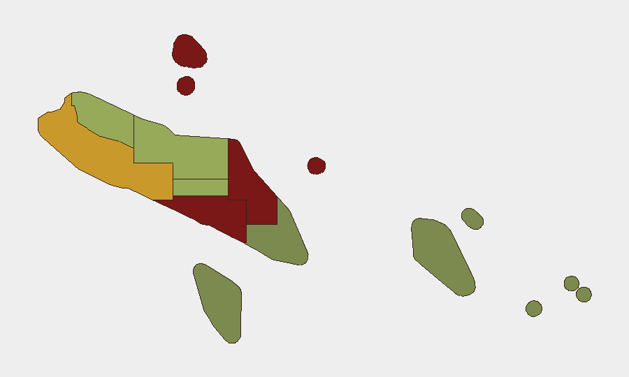
Situation Summary
Solomon Islands remains a persistently fragile operating environment characterized by underlying political volatility, organized crime, and gang activity concentrated in urban centers—most acutely in Honiara. No major security incidents have been reported in the last 24–48 hours. The country's composite threat score (6) reflects endemic rather than acute risks; the security posture has not materially shifted in the immediate term.
Key Developments
- 2026-06-22 · Maritime/Cargo Incident · Honiara Waters. A cargo ship was subject to arrest or detention by Solomon Islands authorities. Details remain limited in open-source reporting; operational implications for maritime traffic and supply-chain continuity warrant monitoring.
- No verified new unrest, protests, riots, or public-order incidents reported in the last 24–48 hours across any province. X/Twitter, regional news feeds, and Solomon Islands Police Force communications contain no reports of fresh disturbances, curfews, or roadblocks as of late 22 June 2026.
- No new travel warnings or government advisories issued in the last 24–48 hours. Major-power travel advisories (Australia, New Zealand, US, UK) remain stable, reflecting ongoing structural crime and political risks rather than imminent threats.
- Background context (for situational awareness only): Honiara and Guadalcanal have experienced cycles of gang violence, communal tension, and crime since the 2020–2023 period; Malaita province exhibits elevated risk linked to provincial governance disputes and resource competition. These are not new developments but persist as the primary drivers of the country's risk profile.
Highest-Risk Areas
Honiara (risk 92) and Guadalcanal (risk 88) dominate the threat landscape, driven by concentrated gang activity, armed robbery, and violent crime in the capital and surrounding areas. Malaita (risk 85) follows, reflecting longstanding provincial governance tensions and inter-communal disputes. Together, these three provinces account for the majority of organized crime, extortion, and interpersonal violence; security teams with personnel or assets in these areas face materially elevated exposure compared to the more stable eastern and southern provinces (Temotu, Rennell and Bellona), where risk scores fall below 25. Western Province (risk 72) presents moderate risk related to resource conflicts and limited state presence.
How GeoBit Would Assist
Security and risk teams operating in Solomon Islands should employ AOI (Area-of-Interest) Monitoring & Early Warning focused on Honiara, Guadalcanal, and Malaita to detect emerging protests, gang activity, or communal violence in real time. Intel Sweep and multi-language OSINT fusion (including X/Twitter, local radio, and government ministry communications) provide 24–48-hour early warning of new unrest or policy changes. Routing & Network Analysis supports duty-of-care planning for staff movement, identifying safe corridors and alternative transit options in high-risk urban zones.
7-Day Outlook
No acute security escalation is forecast for the next seven days based on current open-source indicators and the absence of triggering events in the immediate term. Underlying gang and crime risks in Honiara and Guadalcanal remain persistent; staff safety protocols should remain in effect. Continued monitoring of provincial governance developments and any maritime/customs enforcement actions is advisable.
Highest-Risk Areas — Ranked
| # | State / Region | Risk |
|---|---|---|
| 1 | Honiara | 92 |
| 2 | Guadalcanal | 88 |
| 3 | Malaita | 85 |
| 4 | Western | 72 |
| 5 | Choiseul | 58 |
| 6 | Isabel | 52 |
| 7 | Central Province | 48 |
| 8 | Makira-Ulawa | 38 |
| 9 | Rennell and Bellona | 22 |
| 10 | Temotu | 18 |
Sources
Previous Daily Briefs
A new Solomon Islands brief is written every day — each with its own risk map and downloadable CSV. Here's the last week; use the calendar to go further back.
📅 Browse every day by calendar →
Highlighted days have a brief. Tap a day for that day's map & analysis, or “csv” for that day's dataset ($5).