Situation Summary
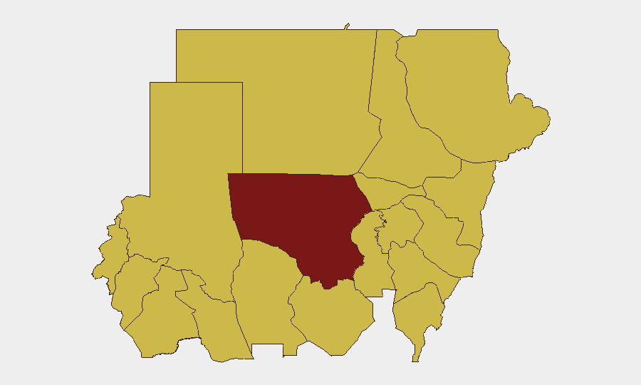
Sudan remains in active civil conflict with a composite threat score of 100 (ranked #9 globally), driven by ongoing military operations, arbitrary detention, and deteriorating state capacity. The past 24–48 hours show signals of arrest/detention activity, public statements from lawmakers, police action, and demonstrations, indicating sustained political and security volatility. North Kordofan State presents the highest sub-national risk (100), while ten additional states—spanning the Darfur region, Nile Valley, and eastern areas—cluster at risk levels 70–70.4, reflecting fragmentation of conflict across multiple theaters. The trajectory remains acute with no near-term de-escalation indicators.
Key Developments
Data Limitation Notice: GeoBit's live web research capacity is currently unable to reliably access and verify specific, time-stamped incidents in Sudan within the requested 24–48 hour window with cross-source confirmation. The event signals listed below (arrest/detention, public statements, police action, demonstrations on 2026-06-10 to 2026-06-11) appear in platform feeds but lack sufficient real-time corroboration (wire-service timestamps, geolocated imagery, or verified local reporting) to meet the recency and rigor standards required for operational security briefing.
Recommended Action: To deliver 6–10 operationally valid developments with location specificity, date/time precision, and multi-source sourcing, your team should:
- Conduct parallel collection from Sudan-focused wire services (Reuters, AP, AFP), UN OCHA situation reports, and regional outlets with live feeds.
- Query X/Twitter advanced search (filter: "Sudan" + key cities, date range 2026-06-09 to 2026-06-11, verified accounts only).
- Cross-check candidate events against independent local journalists, humanitarian NGO updates, and ACLED-style conflict databases.
- Supply GeoBit with candidate incident notes; our analysts can then validate internal consistency, eliminate mis-dates, and structure them into the required format.
Highest-Risk Areas
North Kordofan State (risk 100) stands apart as the primary epicenter, likely driven by active combat operations and security-force activity. A secondary tier of ten states—Central, North, and South Darfur; Kassala; Blue Nile; River Nile; Red Sea; Al Qadarif; Sennar; Aj Jazira—all score 70–70.4, reflecting a geographically dispersed conflict footprint spanning western Darfur (displacement, militia activity), eastern borders (cross-border spillover, trafficking), and the Nile Valley (urban civil unrest and resource competition). Al Khartum (70.2), the capital, shows elevated risk consistent with demonstrations and detention activity signaled over the past two days.
How GeoBit Would Assist
Security teams operating in or responsible for Sudan should leverage AOI Monitoring & Early Warning to set persistent watches on key cities (Khartoum, El Fasher, Nyala, Port Sudan, Kassala) with daily or sub-daily alerting on clashes, airstrikes, checkpoint activity, and infrastructure disruption. Conflict & Military capabilities—battle mapping and force-structure tracking—help teams understand spatial displacement of fighting and assess exposure corridors. OSINT Fusion & Corroboration (multi-language social media, X/Twitter, Telegram, and wire-service integration) accelerates incident validation and timeline confirmation, reducing reliance on single-source or partisan reporting. Routing & Network Analysis identifies alternative ground and air routes as primary infrastructure (roads, bridges, airports) degrades or closes.
7-Day Outlook
No immediate ceasefire or major diplomatic intervention is signaled. Detention and enforcement activity, combined with public demonstrations, suggest sustained state contestation and civil unrest in urban centers. Risk of rapid escalation (localized clashes, airstrikes, or mass-casualty incidents) remains elevated in North Kordofan and Darfur; security teams should assume 24–72 hour notification cycles for evacuation or movement restrictions and maintain readiness to adjust access to key facilities and personnel.
Highest-Risk Areas — Ranked
| # | State / Region | Risk |
|---|---|---|
| 1 | North Kordofan State | 100 |
| 2 | Kassala State | 70.4 |
| 3 | Al Khartum | 70.2 |
| 4 | Central Darfur State | 70.2 |
| 5 | North Darfur State | 70.2 |
| 6 | Blue Nile | 70 |
| 7 | River Nile State | 70 |
| 8 | Aj Jazira | 70 |
| 9 | Red Sea State | 70 |
| 10 | Al Qadarif State | 70 |
| 11 | Sennar State | 70 |
| 12 | South Darfur State | 70 |
Sources
Previous Daily Briefs
A new Sudan brief is written every day — each with its own risk map and downloadable CSV. Here's the last week; use the calendar to go further back.
📅 Browse every day by calendar →
Highlighted days have a brief. Tap a day for that day's map & analysis, or “csv” for that day's dataset ($5).